
Tropical Storm Chantal (2007) facts for kids
| Tropical storm (SSHWS/NWS) | |

Satellite image of Chantal near peak intensity.
|
|
| Formed | July 31, 2007 |
|---|---|
| Dissipated | August 1, 2007 |
| Highest winds | 1-minute sustained: 50 mph (85 km/h) |
| Lowest pressure | 994 mbar (hPa); 29.35 inHg |
| Fatalities | None reported |
| Areas affected | Bermuda, Canada |
| Part of the 2007 Atlantic hurricane season | |
Tropical Storm Chantal was a very quick storm that formed in the northern Atlantic Ocean. It mostly stayed away from land. This storm was the third one to be named during the 2007 Atlantic hurricane season.
Chantal started as a weather system that wasn't tropical. It formed between Bermuda and Cape Cod, Massachusetts, on July 31. The weather conditions were good for it to grow stronger. The storm reached its strongest winds of 50 mph (80 km/h). It then moved quickly northeast into colder waters. As the storm started to weaken, it changed into an extratropical cyclone. This means it became more like a regular weather system. The National Hurricane Center stopped tracking it on August 1. Later, what was left of Chantal moved over southeast Newfoundland before heading into the Arctic Ocean.
Contents
How Tropical Storm Chantal Formed and Moved

On July 28, an area of thunderstorms began to form. It was about 100 miles (160 km) east of the Bahamas. This area was linked to a weak low pressure system. It moved north-northeast, but the weather conditions made it messy.
However, forecasters thought the conditions would get better. By July 29, the National Hurricane Center said it might become a tropical cyclone or subtropical cyclone. On July 30, the low pressure system passed west of Bermuda. It kept moving northeast. It was affected by a large weather system called a trough.
When Did Chantal Become a Tropical Depression?
The system had a clear center that was sometimes covered by thick clouds. By July 31, ships and special satellite tools called QuikSCAT showed winds of 35 mph (55 km/h). The center was well-formed with the clouds. Because of this, the National Hurricane Center named it Tropical Depression Three. It was about 270 miles (435 km) north-northwest of Bermuda.
How Did Chantal Become a Tropical Storm?
Six hours after it formed, the depression had a somewhat clear center. It had strong thunderstorms mostly on its northeast side. The ocean water was warm, about 80º F (27º C). Forecasters thought it had a small chance to become a tropical storm. Then it would change into an extratropical cyclone.
The system got more organized. Based on satellite pictures and QuikSCAT data, the National Hurricane Center upgraded it. It became Tropical Storm Chantal at 1215 UTC on July 31. At this time, it was about 330 miles (530 km) south of Halifax, Nova Scotia.
When Did Chantal Reach Its Strongest Point?
About three hours later, the storm formed clear banding features. Chantal reached its strongest winds of 50 mph (80 km/h). The storm then sped up northeast into an area of cold water and cooler air. Early on August 1, the National Hurricane Center gave its last update on Chantal. This was because it started to change into an extratropical storm.
What Happened After Chantal Weakened?
After becoming an extratropical cyclone, Chantal still had some scattered thunderstorms near its center. However, most of its clouds moved north. On August 1, the storm's remains moved over Newfoundland. This happened near the Avalon Peninsula. By late that day, what was left of Chantal was about 265 miles (425 km) northeast of St. John's, Newfoundland and Labrador. It was moving northeast at 44 mph (70 km/h).
What Impact Did Tropical Storm Chantal Have?
The weather system that later became Chantal started to affect Bermuda on July 30. It brought some thunderstorms. The next day, it caused heavy rain. The Bermuda International Airport recorded 2.12 inches (53.8 mm) of rain. Winds on the island reached 45 mph (72 km/h) because of the system.
After Chantal passed Bermuda, a ship recorded winds of 37 mph (59 km/h).
Warnings Issued for Canada
Soon after the system became a tropical storm, the Atlantic Storm Prediction Center in Canada sent out gale warnings. These warnings were for the waters off Newfoundland. The Newfoundland Labrador Weather Office also warned about heavy rain.
Damage Caused by Chantal
In the open ocean, waves from Chantal reached 20 feet (6 m) high. The storm also affected land. A wind gust of 54 mph (88 km/h) was reported. What was left of Chantal caused a lot of rain in a short time in Newfoundland. In the province, the most rain fell at Whitbourne, with 5.9 inches (150 mm).
The heavy rain caused flooding. It also washed out streets in several towns on the Avalon Peninsula. Several towns in this area declared states of emergency because of the flooding.
Related pages
|
Tropical cyclones of the 2007 Atlantic hurricane season |
|||||||||||||||||||||||||||||||||
|
|
||||||||||||||||||||||||||||||||
|
|
|||||||||||||||||||||||||||||||||
Images for kids
-
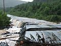
Rattling Brook in Ship Harbour, NL during the flooding.

See also
 In Spanish: Tormenta tropical Chantal (2007) para niños
