
Tropical Depression Ten (2007) facts for kids
| Tropical depression (SSHWS/NWS) | |

Tropical Depression Ten near landfall
|
|
| Formed | September 21, 2007 |
|---|---|
| Dissipated | September 22, 2007 |
| Highest winds | 1-minute sustained: 35 mph (55 km/h) |
| Lowest pressure | 1005 mbar (hPa); 29.68 inHg |
| Damage | Minimal |
| Areas affected | Florida, Georgia, Alabama |
| Part of the 2007 Atlantic hurricane season | |
Tropical Depression Ten was a short-lived tropical cyclone that hit western Florida in September 2007. It was the tenth tropical cyclone of the 2007 Atlantic hurricane season. This storm started as a subtropical depression on September 21. It formed in the northeastern Gulf of Mexico when a tropical wave, the end of a cold front, and a low pressure system met.
At first, the system was messy with disorganized winds and thunderstorms. But later, it became a tropical depression as its thunderstorms got more organized around its center. Moving northwest, the depression reached land near Fort Walton Beach early on September 22. It soon faded away over southeastern Alabama. The depression caused only small damages, mostly light rain. However, the system that later became Tropical Depression 10 did create a damaging tornado in Eustis, Florida.
Contents
How Tropical Depression Ten Formed

Around September 17, a tropical wave and the end of a cold front came together. This created many thunderstorms over the Bahamas and the western Atlantic Ocean. A low pressure system high up in the atmosphere over western Florida caused even more thunderstorms. By September 18, this system began moving towards Florida.
At first, the weather system was very messy. But the air pressure slowly dropped in the area. A weak low pressure area began to form on September 19. On September 20, a special plane called a Hurricane Hunters aircraft flew into the system. It reported an organized low pressure area and strong wind gusts as the system moved into the northeastern Gulf of Mexico. There were still only a few disorganized thunderstorms.
The thunderstorms slowly became better organized. There was a clear band of rain on its eastern side and some scattered thunderstorms near the center. Even though it was still a bit messy, the National Hurricane Center started giving updates on Subtropical Depression Ten on September 21. It was about 40 miles (60 km) south of St. Vincent Island, Florida. They said it had the chance to grow more right along the coast.
Its Journey and End
Because of a high-pressure area called a ridge to its northwest, the subtropical depression was expected to move along the coasts of Florida and Alabama. Forecasters thought it would have winds of 45 mph (75 km/h) and reach land in southern Mississippi.
The storm's center became more organized as thunderstorms increased over it. Within just 6 hours of forming, the system changed into a tropical depression. It kept moving northwest. It made landfall around midnight UTC on September 22 near Fort Walton Beach, Florida. Its winds were about 35 mph (55 km/h).
As the depression moved inland, its cloud pattern started to break apart. Three hours after it hit land, the National Hurricane Center stopped giving updates on it. The depression continued into Alabama, becoming even more disorganized. By 9 AM UTC on September 22, the storm had weakened into just a leftover low pressure area.
Getting Ready and What Happened
.jpg)
When the National Hurricane Center first announced the depression, they also issued a tropical storm warning. This warning covered the area from Apalachicola, Florida to the delta of the Mississippi River. Soon after, an inland tropical storm warning was issued for some counties in Mississippi and a parish in Louisiana. The New Orleans National Weather Service also warned about possible coastal flooding.
In Mississippi, Governor Haley Barbour declared a state of emergency. Officials told people living in low areas and mobile homes in certain counties to leave. In New Orleans, three emergency shelters were opened. This was because many people still lived in FEMA trailers after Hurricane Katrina. Louisiana Governor Kathleen Blanco also declared a state of emergency. She put the state's National Guard and other disaster teams on standby.
Before the depression fully formed, several oil and gas companies moved workers from their oil platforms in the northern Gulf of Mexico. The Shell Oil Company moved about 700 employees. Noble Energy moved about 300 people from two oil rigs. Exxon Mobil stopped producing about 1,000 barrels of oil and 55,000 cubic feet (1,500 cubic meters) of gas. Because 27.7% of the daily crude oil production stopped, oil prices went up. On September 20, they reached a record high of over $84 per barrel.
Effects of the Storm
The winds and swirling air created moderate thunderstorms over central Florida. These storms were linked to the low pressure system that came before the depression. Late on September 20, a very strong thunderstorm called a supercell formed near Lake Apopka. It moved quickly north and created an EF1 tornado near Eustis, Florida. This tornado traveled about 2 miles (3 km) and had winds of about 100 mph (160 km/h).
The tornado destroyed 20 homes and badly damaged 30 others. One person was injured, and about 300 people lost power. The depression also caused waves of about 5 feet (1.5 m) and dangerous rip currents along Florida's west coast. Rain started falling in coastal parts of western Florida about 12 hours before the depression officially formed.
The most rain in Florida was 2.83 inches (71.9 mm) in Crestview. Other places also got rain. Albany, Georgia received 1.46 inches (37.1 mm), and Dothan, Alabama got 0.51 inches (13 mm).
Related pages
|
Tropical cyclones of the 2007 Atlantic hurricane season |
|||||||||||||||||||||||||||||||||
|
|
||||||||||||||||||||||||||||||||
|
|
|||||||||||||||||||||||||||||||||
Images for kids
-
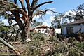
Tornado damage in Eustis, Florida
See also
 In Spanish: Depresión tropical Diez (2007) para niños
