
Tropical Storm Gabrielle (2007) facts for kids
| Tropical storm (SSHWS/NWS) | |

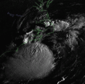
Tropical Storm Gabrielle near landfall.
|
|
| Formed | September 8, 2007 |
|---|---|
| Dissipated | September 11, 2007 |
| Highest winds | 1-minute sustained: 60 mph (95 km/h) |
| Lowest pressure | 1004 mbar (hPa); 29.65 inHg |
| Fatalities | None reported |
| Damage | Minimal |
| Areas affected | North Carolina |
| Part of the 2007 Atlantic hurricane season | |
Tropical Storm Gabrielle was a storm that moved across eastern North Carolina before heading out into the ocean. It was the seventh storm to be named during the 2007 Atlantic hurricane season. Gabrielle started as a subtropical cyclone on September 8, 2007. It formed about 385 miles (625 km) southeast of Cape Lookout, North Carolina.
Strong winds high in the atmosphere, called wind shear, affected the storm. This wind shear often stopped Gabrielle from getting stronger. However, for a short time, the wind shear lessened. This allowed Gabrielle to become a tropical storm. On September 9, Gabrielle reached the coast of North Carolina. After hitting land, the storm turned northeast. It quickly became weaker and disappeared by September 11. Gabrielle brought heavy rain to the area where it landed. But other places received very little rain. The storm caused only minor damage, and no one was reported to have died.
Contents
How Did Tropical Storm Gabrielle Form?

A cold front that was fading moved away from the coast of Georgia on September 2. It left behind clouds and rain showers that slowly moved east. These clouds and showers started to get more organized. By late on September 4, the thunderstorms had grown bigger east of the system's center. On September 5, a special plane called a Hurricane Hunters aircraft flew into the system. It reported that the system had not yet become a tropical cyclone or a subtropical cyclone.
A weather feature called a trough caused some wind shear. This wind shear stopped the storm from getting stronger. However, the weather conditions in the area soon improved, making it easier for the storm to grow.
Gabrielle Becomes a Subtropical Storm
The storm began to grow about halfway between North Carolina and Bermuda. It started to move slowly toward the west-northwest. On September 7, its center became a bit stronger. On September 8, the National Hurricane Center officially named the storm Subtropical Storm Gabrielle. At this time, Gabrielle was about 385 miles (625 km) southeast of Cape Lookout, North Carolina.
After becoming a subtropical storm, Gabrielle was in an area with several challenges. There was cooler air to the north and dry air to the south and west. There was also some wind shear, and the water temperatures along the storm's path were cooler. These conditions made it hard for the storm to get much stronger.
However, a curved line of thunderstorms formed in the northern and western parts of the storm. The storm's circulation, or spinning, became better organized. Later, these rainbands faded away. This left the center of the low pressure system far from the main thunderstorms. For a strong tropical cyclone to form, the center and the thunderstorms need to be right over each other. Soon, the storm began to gain more strength. It was renamed Tropical Storm Gabrielle on September 7. At this point, it was about 185 miles (300 km) southeast of Cape Lookout, North Carolina.
Gabrielle Hits North Carolina
The wind shear slowly decreased as the storm moved over the Gulf Stream. This allowed strong thunderstorms to quickly form near the storm's center. At about 3:45 PM UTC, Tropical Storm Gabrielle hit the coast of North Carolina. It had winds that might have been as strong as 60 miles per hour (95 km/h) when it made landfall.
The storm then turned north and north-northeast. It moved back into the ocean on September 10. Gabrielle weakened to a tropical depression. It still had some scattered thunderstorms as it moved along the northern part of the Gulf Stream. By midday on September 11, Gabrielle died out south of Canada. By early the next day, what was left of Gabrielle was absorbed by another cold front.
How Did People Prepare for Gabrielle?
When Gabrielle became a subtropical storm, the National Hurricane Center issued a tropical storm watch. This watch covered the area from Edisto Beach, South Carolina to Oregon Inlet in North Carolina, including the Pamlico Sound. As the storm got closer to land, the storm watch for areas south of Cape Fear, North Carolina, was removed. At the same time, a tropical storm warning was put in place. This warning stretched from Surf City, North Carolina to the North Carolina – Virginia state border. A tropical storm watch was also issued for parts of the Delmarva Peninsula and Chesapeake Bay.
Before the storm arrived, the National Park Service closed visitor centers and campgrounds along the Outer Banks. The ferry between Hatteras and Ocracoke was closed for about 12 hours. The governor of North Carolina put rescue teams on standby, ready to help if needed. Some people were told to secure loose objects around their homes. They were also advised to stay indoors when the storm passed. Because Tropical Storm Gabrielle was expected to be minor, no evacuations were ordered. On Ocracoke Island, people moved their boats out of the water to prepare for Gabrielle. The threat of the storm caused a fishing contest at Atlantic Beach to be canceled.
At first, forecasters, or weather experts, were not sure exactly where Gabrielle would go. They thought it was possible for the storm to hit areas as far north as New York. Big waves and rip currents were predicted. So, the Coast Guard helped prepare for the storm in the Northeastern United States. On Cape Cod, Massachusetts, a jet airplane flew along the coastline. It gave storm advisories to boats offshore. A Coast Guard patrol boat was sent out to sea for search and rescue. Sailors were told to be very careful during the storm. However, the storm passed far to the south, causing little effect in those northern areas.
What Was the Impact of Tropical Storm Gabrielle?

Big waves from Gabrielle hit the coast of Florida. These waves caused a surfer to drown. Around 200 other people had to be rescued from the rough seas. People at New Smyrna Beach, Florida reported that waves reached 6 to 9 feet (1.8 to 2.7 meters) high.
By September 9, the outer rainbands of the storm began hitting southeastern North Carolina. Strong, steady winds occurred along the coast. They reached 44 miles per hour (71 km/h) at Frisco. Wind gusts were sometimes even stronger. A gust of 61 miles per hour (98 km/h) was recorded at Ocracoke. Along the coast of North Carolina, waves were 10 to 12 feet (3 to 3.7 meters) high. Rip currents caused many swimmers to be rescued by lifeguards.
Most areas did not get much rain from the storm. However, near the storm's center, 9.03 inches (229 mm) of rain fell. In the areas where the most rain fell, some flooding occurred. This flooding prevented farmers from harvesting their crops. Much of North Carolina was experiencing a drought. So, people hoped Gabrielle would bring much-needed water. However, in most places, no rain occurred.
The storm caused part of North Carolina Highway 12 on Hatteras Island to close for three hours due to flooding. Other streets in Morehead City and Beaufort were also closed. A few buildings in the area had minor damage from the flooding. In Carteret County, the flood waters caused about $5,000 in damage. The Storm surge from Gabrielle was small. It was only about 3 feet (0.9 meters) above normal at Hatteras Island. Overall, the damage in North Carolina was minor, and no one died.
When the storm was called "Gabrielle," it was the fourth time that name had been used for a tropical cyclone in the Atlantic Ocean. The name was used before in 1989, 1995, and 2001. Because Tropical Storm Gabrielle was not a very strong or damaging storm, its name was not retired. The name Gabrielle was later used again for the 2013 Atlantic hurricane season.
Related Pages
- NHC's advisory archive on Tropical Storm Gabrielle.
|
Tropical cyclones of the 2007 Atlantic hurricane season |
|||||||||||||||||||||||||||||||||
|
|
||||||||||||||||||||||||||||||||
|
|
|||||||||||||||||||||||||||||||||
Images for kids
-
Animation of Tropical Storm Gabrielle making landfall in North Carolina, while being sheared apart

