Typhoon Rammasun facts for kids
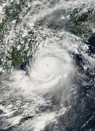
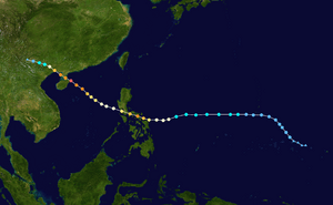
Rammasun at peak intensity nearing Hainan on July 18
|
|
| Formed | July 9, 2014 |
| Dissipated | July 20, 2014 |
| Fatalities | 225 total |
| Damage | $8.08 billion (2014 USD) |
Typhoon Rammasun, also called Typhoon Glenda in the Philippines, was a very strong storm in July 2014. It was one of only three "super typhoons" ever recorded in the South China Sea. The other two were Pamela in 1954 and Rai in 2021. Rammasun caused a lot of damage in the Philippines, South China, and Vietnam.
The name "Rammasun" comes from the Thai language. It means "thunder god." This typhoon was the third tropical cyclone and the first typhoon to hit the Philippines in 2014. It started near the equator, where winds from the north and south meet. This area is called the Intertropical Convergence Zone. The storm slowly moved northwest.
After passing through the islands of Micronesia, Rammasun turned west. It quickly grew stronger because of a high-pressure area called a subtropical ridge. Experts thought it would become a typhoon before hitting the Philippine island of Luzon. The storm was first expected to hit Cagayan Valley. But it moved more to the west. It then hit the Bicol Region and passed near Metro Manila.
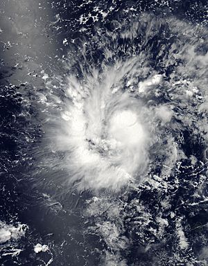
Before the storm hit, the Governor of Guam, Eddie Calvo, told everyone to get ready. He raised the alert level to "Condition of Readiness 1." On July 11, satellites from NASA showed Rammasun passing right over Guam. The American National Weather Service said that strong winds high up in the air stopped the storm from getting much stronger over Guam.
Rammasun hit Guam as a tropical depression, which is a weaker storm. The winds were not as strong as expected. But the island still got a lot of rain. It was the wettest day in about three months. Guam received about 25 to 50 millimeters (1 to 2 inches) of rain.
Besides the Philippines, Taiwan also expected Rammasun to affect it. Weather experts predicted moderate to heavy rain across most of Taiwan. Chinese weather forecasters watched for the storm to hit Hainan province and northern Vietnam. People in Hong Kong were warned about heavy rain and possible landslides.
Many people were stuck at ports because ships could not travel. More than 100 passengers were stranded at the Port of Batangas. About 841 passengers were stuck in five ports in the Bicol region. These ports included Matnog and Tabaco.
A total of 50 flights were canceled. Over 100,000 families had to leave their homes as the typhoon got closer. The Philippine Department of Health said they had prepared all government hospitals. They were ready to help with rescue and relief efforts. They felt much better prepared than for earlier typhoons.
A city in Albay province declared a state of calamity before the storm hit. This means they needed special help. Around 5:00 PM Philippine time, Rammasun's eye passed directly over Rapu-Rapu, Albay. The storm was at its strongest point then. Many parts of the National Capital Region lost power during the storm. This happened because of problems with the power system. Laguna was one of the areas hit very hard by the typhoon. About 6,000 people were stranded at different seaports.
As the typhoon moved through southern Luzon, it stayed very strong. It even got stronger as it crossed the Bicol Region.
Contents
How the Storm Formed and Grew
On July 9, the Joint Typhoon Warning Center (JTWC) in the United States started watching a weather disturbance. It was east of Chuuk State in Micronesia. This system had a wide, unclear center with scattered clouds and thunderstorms. Over the next day, it slowly became more organized. The clouds started wrapping around its center.
The next day, both the Japan Meteorological Agency (JMA) and the JTWC called it a tropical depression. The JTWC gave it the number 09W.
On July 11, the JTWC first said the system had become a tropical storm. But later that day, as it neared Guam, they changed their minds. They said it was still a tropical depression. This was because other weather agencies and observations from Guam showed it was not strong enough. The storm's center was not well-defined.
On July 12, the JMA reported that the depression had become a tropical storm. They named it Rammasun. It passed through the Rota Channel, north of Guam. As Rammasun moved west, the JTWC also said it was a tropical storm again. This was because other agencies agreed, and the storm looked more organized.
Rammasun entered the area watched by the Philippines on July 13. It was given the local name Glenda. The storm kept its strength. A new burst of strong thunderstorms developed in its center. The storm's center became clearer. Over the next few hours, the winds that could tear the storm apart became weaker.
Rammasun moved west, guided by a high-pressure area. The storm's "outflow" (air flowing out from the top) improved. Rammasun then became a typhoon. Its center became solid, and the storm bands wrapped tightly around it. On July 14, both the JTWC and the JMA upgraded Rammasun to a typhoon. They estimated its winds were about 65 knots (120 km/h or 75 mph).
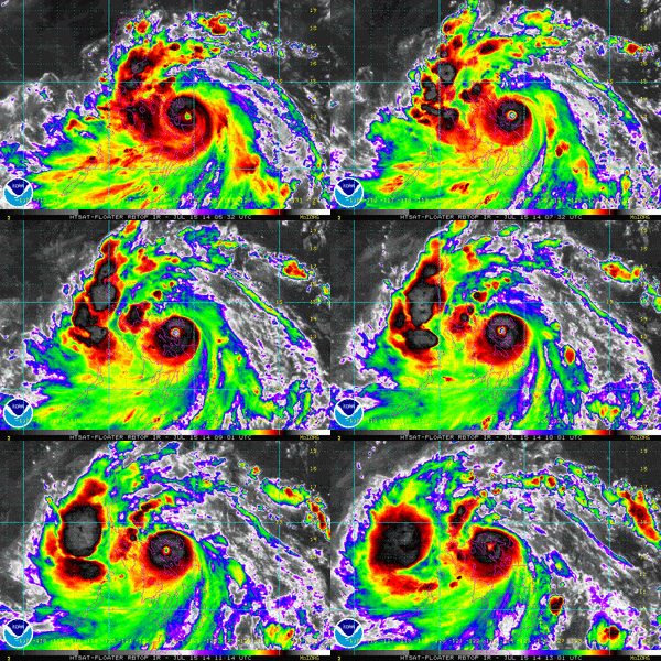
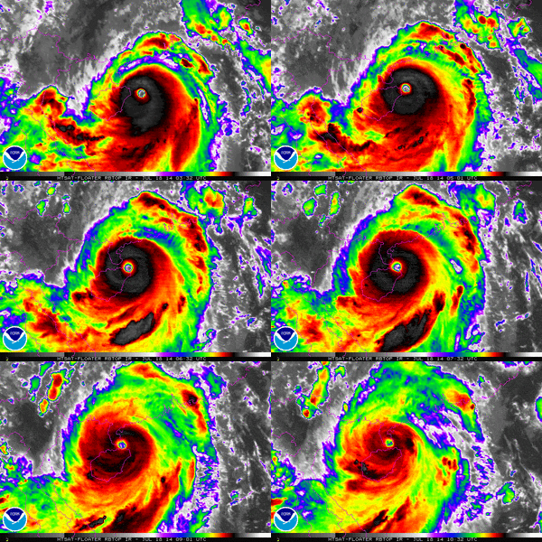
Just before hitting the Philippines, Rammasun developed a clear eye, about 10 nautical miles (18.5 km) wide. The storm had strong outflow. At this time, its winds were peaking at 80 knots (148 km/h or 92 mph) for one minute. Experts first thought it would weaken after hitting land. But Rammasun got even stronger.
About six hours later, the JTWC saw a 20 nautical mile (37 km) wide eye, twice as big as before. Its one-minute winds were 100 knots (185 km/h or 115 mph). This is like a Category 3 hurricane. Rammasun kept getting stronger, even after hitting land. It was in a very good environment to grow. The JTWC later said its winds were 115 knots (213 km/h or 132 mph). This made it a Category 4-equivalent typhoon.
By July 16, Rammasun's eye moved out into the South China Sea. The typhoon lost its clear eye because it interacted with the rough land of the Philippines. Its cloud structure looked a bit worse. But the storm bands still wrapped tightly around its center.
On July 18, Rammasun moved into an area with very warm ocean water. Because of this, Rammasun quickly got much stronger. The JTWC upgraded it to a Category 4 super typhoon. Later, after checking the data again, they said it was a Category 5 super typhoon.
Later that day, Rammasun hit Hainan at its strongest point. This made it one of only two typhoons to hit China as a Category 5-equivalent storm. During its landfall, a weather station recorded a very low air pressure of 899.2 millibars. This was one of the lowest pressures ever recorded in China and worldwide.
The next day, the storm started to weaken. Both agencies downgraded Rammasun to a tropical storm. It moved into Guangxi province and made its third landfall. The JTWC stopped issuing warnings for the storm that night. On July 20, the JMA said Rammasun had weakened into a tropical depression. It was last seen over Yunnan province in China.
Getting Ready and What Happened
Mariana Islands
On July 10, the National Weather Service in Tiyan, Guam, issued a tropical storm watch. This was for Guam, Rota, Tinian, Saipan, and nearby waters. The Governor of Guam, Eddie Calvo, declared "Tropical Cyclone Condition of Readiness 3." This meant strong winds were possible within 48 hours.
Later, tropical storm warnings were issued for Guam and Rota. "Condition of Readiness 2" was declared for Guam. All non-essential government offices and businesses closed. Six elementary schools became storm shelters. Pregnant women were asked to go to the hospital.
On July 11, "Condition of Readiness 1" was declared. This meant destructive winds were expected within 12 hours. All outdoor activities were stopped. The warnings were canceled the next day when the storm weakened. The Governor changed the alert back to the usual seasonal level. The weather service noted that Guam could have had much worse weather.
Philippines
| Rank | Storm | Season | Damage | Ref. | |
|---|---|---|---|---|---|
| PHP | USD | ||||
| 1 | Yolanda (Haiyan) | 2013 | ₱95.5 billion | $2.2 billion | |
| 2 | Odette (Rai) | 2021 | ₱51.8 billion | $1.02 billion | |
| 3 | Pablo (Bopha) | 2012 | ₱43.2 billion | $1.06 billion | |
| 4 | Glenda (Rammasun) | 2014 | ₱38.6 billion | $771 million | |
| 5 | Ompong (Mangkhut) | 2018 | ₱33.9 billion | $627 million | |
| 6 | Pepeng (Parma) | 2009 | ₱27.3 billion | $581 million | |
| 7 | Ulysses (Vamco) | 2020 | ₱20.2 billion | $418 million | |
| 8 | Rolly (Goni) | 2020 | ₱20 billion | $369 million | |
| 9 | Paeng (Nalgae) | 2022 | ₱17.6 billion | $321 million | |
| 10 | Pedring (Nesat) | 2011 | ₱15.6 billion | $356 million | |
Rammasun (Glenda) was the first typhoon to hit the Philippines in over eight months. Preparations started on July 14. The National Transmission Corporation made sure their communication equipment and repair supplies were ready. They also placed repair crews in key areas.
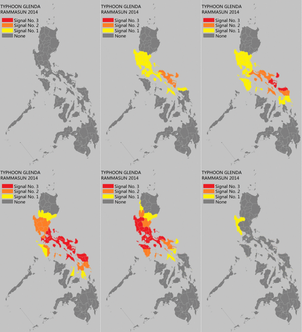
Storm warning signal number 3 was raised for Catanduanes. Signal number 2 was for areas like Camarines Norte and Marinduque. Several islands in southern Luzon and eastern Visayas were under signal number 1. Over 12 million people were told to get ready for the typhoon. Classes were canceled for two days.
Alexander Pama, head of the National Disaster Risk Reduction and Management Council, warned people about landslides, flash floods, and strong winds. More than 1,300 villages were told about possible floods or landslides. The U.S. Embassy in Manila canceled visa interviews.
The Philippine Coast Guard told all ships not to travel. Spokesperson Armand Balilo said authorities were ready to stop ships from sailing. Department of the Interior and Local Government Director Edgar Tabell said all offices were active. Evacuation centers were ready, and power lines, bridges, and roads were checked. He asked local officials to help residents.
As the typhoon neared, the whole country was on red alert. By July 15, the government evacuated eastern coastal areas. PAGASA warned of "storm surges" up to three meters (10 feet) high. A storm surge is a rise in sea level caused by the storm. Many residents fled their homes as the typhoon got stronger than expected.
The civil defense chief of Bicol said they were preparing for the worst. About 6,000 residents had already moved to evacuation centers. Authorities aimed to get another 39,000 people to shelters. Several cities were warned of storm surges from 1.5 meters (5 feet) to 3 meters (10 feet).
After the storm hit, three fishermen were reported missing. They had gone fishing from Catanduanes and did not return. A wall collapse in Quezon City injured two people.
About 90% of Metro Manila residents lost power. Power poles fell, and lines were downed. The National Grid Corporation of the Philippines said this was due to downed poles and lines. Strong winds destroyed many homes in poorer areas. Most of the capital was shut down. In total, Rammasun killed 106 people. It caused about 38.6 billion Philippine pesos (US$885 million) in damage.
Highest Public Storm Warning Signal
| PSWS# | LUZON | VISAYAS | MINDANAO |
|---|---|---|---|
| PSWS #3 | Catanduanes, Albay, Sorsogon | Northern Samar | NONE |
| PSWS #2 | Camarines Norte, Camarines Sur, Masbate incl. Burias and Ticao Islands, Marinduque, Southern Quezon | Northern part of Samar, Northern part of Eastern Samar | NONE |
| PSWS #1 | Romblon, Occidental Mindoro, Oriental Mindoro, Lubang Island, Batangas, Cavite, Laguna, Rizal, Bulacan, Pampanga, Bataan, Zambales, Tarlac, Nueva Ecija, Pangasinan, Southern Aurora, rest of Quezon incl. Polillo Island, Metro Manila | rest of Eastern Samar, rest of Samar, Northern Leyte incl. Biliran Island | NONE |
Hong Kong
On July 16, the Hong Kong Observatory issued the Typhoon Standby Signal No. 1. The next day, they issued Typhoon Signal Number 3 as local winds got stronger. Strong winds were recorded offshore and on higher ground. The storm passed about 390 km (242 miles) southwest of Hong Kong on July 18. Winds slowly died down, and the signals were canceled on July 19. At least 51 trees were blown down. There were also reports of fallen objects, like a lamp post.
China
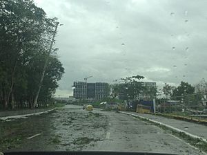
On July 17, Rammasun hit near Wenchang City on Hainan island. The city's mayor, Liu Chun-mei, said many houses were damaged. More than 700,000 people were evacuated. Qionghai also suffered heavy damage. Hainan closed all its airports and schools. Resorts were ordered to close, and high-speed trains were stopped.
The typhoon killed one person on the island and injured 21. Waves reached up to 13 meters (43 feet) on the northern and eastern coasts. The local government sent 66 officials to supervise preparations. Xinhua reported that 6,000 people on Hainan were evacuated. Bus companies also stopped services due to heavy rains and strong winds.
In Hainan, 51,000 homes were destroyed. In China, 88 people died. The total economic losses were about 44.33 billion Chinese yuan (US$7.14 billion).
Vietnam
On July 18, Vietnamese officials ordered people to evacuate from parts of the northern coast. Typhoon Rammasun affected provinces like Haiphong, Thái Bình, and Nam Định. Officials in Quảng Ninh Province moved over 1,300 people to safe shelters. Prime Minister Nguyễn Tấn Dũng ordered authorities to help with evacuations. He also told all boats to stay near the shore. The army was told to prepare for search and rescue.
Heavy rains caused minor flooding in cities like Hai Phong and the capital, Hanoi. Streets were submerged. A government official ordered the cancellation of "all administrative meetings." Residents near the coast were moved to evacuation sites. All ships and boats were banned from leaving port.
The National Center for Hydro-Meteorological Forecasting said the storm's eye was about 210 kilometers (130 miles) east of Hoàng Sa. Wind speeds reached 149 kilometers per hour (93 mph). Mountainous provinces like Bắc Kạn and Cao Bằng were on high alert for flash floods and landslides. Over twenty flights by Vietnam Airlines were canceled or delayed. The trade department saved food and goods to support at least 250,000 people in an emergency.
Overall, about 500 homes were damaged. In Vietnam, Rammasun caused 31 deaths. It also caused damages of US$59 million.
Retirement of the Name
Because of the damage it caused in the Philippines, China, and Vietnam, the name Rammasun was retired. This means it will not be used for future typhoons. This decision was made in 2015.
The name Glenda was also retired by PAGASA (the Philippine weather agency). This happened because the damages were more than 1 billion Philippine pesos. The name Gardo was chosen to replace Glenda for the 2018 season. In February 2016, Thailand suggested new names for Rammasun. A month later, the name Bualoi was chosen. It was first used in 2019.
See also
 In Spanish: Tifón Rammasun para niños
- Typhoons in the Philippines
- Typhoon Imbudo
- Typhoon Xangsane
- Typhoon Nesat (2011)
- Typhoon Utor
- Typhoon Hagupit (2014)
- Typhoon Sarika
- Typhoon Vicente
- Typhoon Son-Tinh (2012)
- Typhoon Mujigae
- Typhoon Vera (1983) - Had a similar track
- Typhoon Melor
- Typhoon Goni - A powerful typhoon which struck similar locations in the Philippines
- Typhoon Rai - Another destructive typhoon which also intensified to a Category 5 equivalent typhoon in the South China Sea
- Tropical Storm Nalgae


