Via Augusta facts for kids
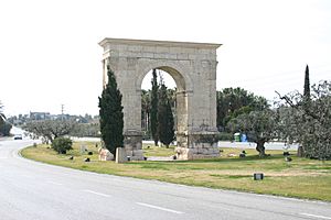
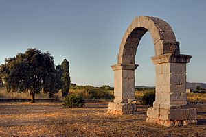
The Arch of Berá on the Via Augusta
|
|
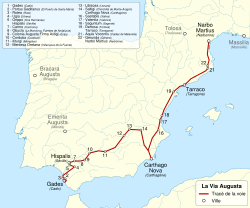
Route of the Via Augusta
|
|
| Location | Roman province of Hispania (Spain, southern France) from Gades (Cádiz) to Pertusium (Coll de Pertús) in the Pyrenees |
|---|---|
| Type | Roman road |
| History | |
| Builder | Roman Empire, Augustus Caesar |
| Periods | 8 BC - 2 BC |
The Via Augusta was a very important Roman road in ancient Hispania (which is now Spain and Portugal). It was also called the Via Herculea or Via Exterior. This road was the longest and busiest of all the Roman roads built in the Iberian Peninsula.
Historians say it was more like a system of roads than just one single road. It stretched about 1,500 km (930 mi) long! The Via Augusta connected Spain with Italy. It ran from the city of Gades (Cádiz) in the southwest, all the way to the Pyrenees Mountains. It followed valleys inland, parallel to the Mediterranean Sea coast. This road was the main route for travel and trade in Roman Hispania. You can find it mentioned in old travel guides like the Vicarello Cups and the Antonine Itinerary.
The road got its name from Emperor Augustus. He ordered it to be rebuilt and extended between 8 BC and 2 BC. Before that, parts of it were called the Via Herculea. Augustus had the road stretched all the way to Gades. The Romans used parts of older roads that were already there. The Via Augusta became a super important route for communication and trade between cities, provinces, and ports. Even in the 10th century, Muslim rulers in southern Spain used it. They called it al-Racif. Today, parts of the N-340 road and the A-7 highway follow the same path.
North of Tarragona, you can still see a Roman Triumphal arch, called the Arc de Berà. The road splits around it. At Martorell, the old Via Augusta crosses the Llobregat river on the Pont del Diable (Devil's Bridge). This bridge was built in the Middle Ages, around 1289. Some parts of the modern N-340 road were even used as the Roman road until the 1920s!
Contents
Why the Via Augusta Was Built
The Roman Empire was famous for building roads everywhere it conquered. After the Romans took over Hispania, they started building roads there too. Hispania was the Roman name for the land that is now Spain, Portugal, Andorra, and southern France.
Emperor Augustus visited Spain between 16 and 13 BC. He saw that better roads were needed. So, he ordered the building of the Via Augusta. It became the longest and most important road in Hispania. The road went from near the southern tip of Spain, along the Atlantic coast, through the Guadalquivir valley, and up the Mediterranean coast to the Coll de Pertús pass in the Pyrenees.
The Via Augusta connected the southern part of Hispania (called Hispania Baetica) with the north. You can still see the Alcantarilla bridge over the River Salado in Utrera. It's about 32 km (20 mi) south of Seville. This bridge has an inscription that shows it was part of the Via Augusta. The Romans also built a fifteen-arched bridge over the River Baetis (the Guadalquivir) at Andújar.
In the first century AD, during the time of peace called Pax Romana, the Roman city of Carmo (now Carmona) became a major crossroads on the Via Augusta. It was an important Roman outpost.
What Remains of the Via Augusta Today
You can still find parts of the old roadbed today. It often follows the path of the modern AP-7 motorway. There's a long visible stretch in El Perelló, near Tarragona. The Arc de Berà is on the section just south of Tarragona.
Roman Barcelona (Barcino) was in a great spot on a side road of the Via Augusta. This helped the city grow in trade and business. In modern Barcelona, one of the main avenues is also called "Via Augusta." It connects the Avinguda Diagonal with the Vallvidrera tunnels. A large part of line 6 of the Generalitat of Catalonia Railways runs underneath this modern Via Augusta.
The Roman Arch of Cabanes is about 19 km (12 mi) northwest of Castellón. It crosses the Via Augusta, which followed an inland valley there. This arch is now in a roundabout. The modern CV-157 road still looks a bit like the old Roman roads, with rows of trees. However, the original path of the Via Augusta doesn't always match today's roads. The Via Augusta often went through less populated areas, usually in inland valleys. Most Roman cities, especially those on the coast, were reached by smaller roads that branched off the main Via Augusta.
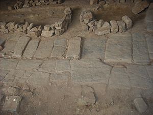
In Valencia, you can see traces of the Via Augusta in two main places. One is near the Valencia Cathedral at the Almoina Archaeological Centre. Here, you can see parts of the road's pavement. There are also remains of columns from the Temple of the Nymphs, a stone well, and old houses. You can also find milestones (marker stones) in San Vicente street and the Alameda de Valencia.
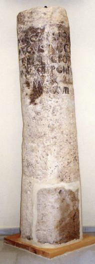
The city of Lorca (called Eliocroca by the Romans) in the Murcia province also has parts of the Via Augusta. This includes two Roman columns, called the San Vicente Ferrer and Baldazos milestones. These are now in the Archaeological Museum of Lorca. The San Vicente Ferrer column is from the time of Emperor Augustus (8–7 BC).
The inscription on the San Vicente Ferrer Column says:
IMPERATOR CAESAR DIVI FILIVS / AGVSTVS CONSVL XI / TRIBVNICIA POTESTATE XVI / IMPERATOR XIIII PONTIFEX. / MAXIMVS / MILLE PASSVS XXVIII
This means:
Emperor Caesar Augustus, son of the Divine, Consul for the 11th time, his 16th year of tribunal power, General in 14 campaigns and Chief High Priest, mile 28 [from Carthago Nova (Cartagena) towards Eliocroca (Lorca}]
How the Via Augusta Was Built
The Via Augusta was a huge imperial road for Spain. It connected with other major Roman roads like the Via Julia Augusta, Via Aemilia, and Via Flaminia. This created a chain of roads linking Rome all the way to the Atlantic Ocean. The road helped cities like Valentia (Valencia), Saguntum (Sagunto), Lucentum (Alicante), Saetabis (Xàtiva), and Ilici (Elche) grow and develop.
Roman engineers planned the road carefully. They looked at the land's slope and used existing old Iberian roads. The Via Augusta was usually between four and six metres wide. Some parts were even wider, up to ten or fourteen metres. Near cities, there were sidewalks (called margines or crepidines) that were three to ten metres wide on each side.
The Via Augusta started at the Coll de Pertús pass in the Pyrenees. It ran south and southwest to the River Baetis. From there, it continued through Baetica to Gades. Where the road crossed the Baetis river, the Romans built a special arch called the Ianus Augusti to honor Augustus. All the milestones from this arch to Gades were numbered.
Milestones Along the Way
Milestones were stone pillars placed along Roman roads. They showed the distance between important points. Each milestone marked a distance of a thousand paces (a Roman double step called a mille passum). This was equal to a Roman mile, about 1.480 metres.
These milestones were usually cylindrical stone columns. They were made of granite or sandstone, about 2 to 3 metres high and 50 to 80 cm wide. They stood on a square base. The stones had important information carved on them. This included the name of the person who built or repaired the road, the name of the nearest town, and the distance. Sometimes, they also showed the starting point or ending point of the road.
Building the Road Network
The building of the Via Augusta was part of a bigger plan by Emperor Augustus. He wanted to reorganize the Roman provinces in Hispania. Before this, Marcus Vipsanius Agrippa had built a network of roads called the Via Agrippa in Gaul (modern France). Augustus wanted a similar system in Hispania.
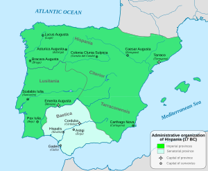
Augustus himself came to Hispania between 16 and 13 BC. He and his advisors created a big plan. It included building new cities, connecting them with roads, and giving land to veteran soldiers. With Hispania fully under Roman control, Augustus decided to build a proper road system. The main network was finished during his rule. He repaired and relaid the coastal road from Tarraco (which was his headquarters and the capital of Hispania Tarraconensis) through Valentia to Carthago Nova (Cartagena). He also improved the road through the Baetis valley, passing through Corduba and Hispalis to Gades. Many milestones with his name have been found on this section.
Building this road network helped connect Hispania with the rest of the Mediterranean world. Old travel guides and milestones show that this was a huge project. There were four main routes connecting important cities like Bracara Augusta (Braga), Asturica Augusta (Astorga), and Lucus Augusti (Lugo). Caesaraugusta (Zaragoza) and Carthago Nova were also important cities and crossroads.
Augustus ordered the road from Caesaraugusta to Tarragona to be built. Later, Emperor Domitian extended the road from Caesaraugusta to Olispo (Lisbon). This road went through Toletum (Toledo) and Augusta Emerita. Augusta Emerita was the starting point of the road (later called the "silver way"). This road went north to Salamanca and Oceloduri. There, it met the road along the Ebro river.
Asturica Augusta was an important junction where roads to Lusitania and the Cantabrian coast met. It later became part of the famous pilgrimage route to Santiago de Compostela. In the south, Emerita and Gades were connected by the Hispalis road. This road joined a branch of the Via Augusta that went inland to Corduba, Astigi (Écija), and Carmo. This was the main Roman road system in Hispania. With smaller local roads, it covered about 21,000 km (13,000 mi).
Milestones show that Augustus built roads from Bracara to Asturica, from Caesaraugusta to Juliobriga (Reinosa), and from Emerita (Mérida) to Hispalis (Seville). He also built roads to important mining areas. Augustus created a large circle of roads around Hispania, with some branches going inland. Later emperors added more direct routes to fill in the network.
The Via Augusta was first a via militaris, meaning a military road. Roman soldiers (legionaries) built a lot of the road network, especially at the beginning of the empire. These roads remained important for military use, but their main purpose became general communication. An inscription found near Corduba (Córdoba) shows this. In the year 90 AD, Domitian ordered the Via Augusta to be repaired because it was falling apart. This section was still called a via militaris.
The inscription said:
VIAM AVGVSTAM MILITAREM / VETVSTATE CORRVPTAM RESTITVIT.
In English, this means:
He restored the via militaris Augusta, which had become dilapidated through old age.
Cities Along the Via Augusta
Here are some of the important cities the Via Augusta passed through:
- Gades (Cádiz)
- Ad Portus (El Puerto de Santa María)
- Asta Regia (Jerez de la Frontera (Mesas de Asta))
- Ugia (Torre Alocaz), Utrera
- Orippo (Dos Hermanas)
- Hispalis (Seville)
- Carmona (Carmona)
- Obucla u Obúlcula Fuentes de Andalucía (La Monclova))
- Colonia Augusta Firma Astigi (Écija)
- Adaras (La Carlota)
- Corduba (Córdoba)
- Iliturgi (Mengíbar, where it crossed the Betis River on the Bridge of Andújar (Guadalquivir)
- Isturgi (Andújar)
- Castulo (Linares)
- Mentesa Oretana (Villanueva de la Fuente)
- Saltigi (Chinchilla de Monte-Aragón)
- Libisosa (Lezuza)
- Ad Ello (Elda)
- Carthago Nova (Cartagena)
- Eliocroca (Lorca)
- Sucro (Albalat de la Ribera)
- Saetabis (Xàtiva)
- Valentia (Valencia)
- Saguntum (Sagunt)
- Intybilis (La Jana)
- Dertosa (Tortosa)
- Tarraco (Tarragona)
- Barcino (Barcelona)
- Baetulo (Badalona)
- Aquis Vocontis (Caldes de Malavella)
- Gerunda (Girona)
- Narbo Martius (Narbonne), France
See also
 In Spanish: Vía Augusta para niños


