
Wallasey facts for kids
Quick facts for kids Wallasey |
|
|---|---|
| Town | |
 Wallasey Town Hall |
|

Wallasey
|
|
| Population | 60,284 (2011 Census) |
| OS grid reference | SJ293923 |
| • London | 180 mi (290 km) SE |
| Metropolitan borough | |
| Metropolitan county | |
| Region | |
| Country | England |
| Sovereign state | United Kingdom |
| Post town | WALLASEY |
| Postcode district | CH44, CH45 |
| Dialling code | 0151 |
| ISO 3166 code | GB-WRL |
| Police | Merseyside |
| Fire | Merseyside |
| Ambulance | North West |
| EU Parliament | North West England |
| UK Parliament |
|
Wallasey is a town located in Merseyside, England. It's part of the Metropolitan Borough of Wirral. You can find Wallasey at the mouth of the River Mersey, on the northeast tip of the Wirral Peninsula. In 2011, about 60,284 people lived there.
Contents
History of Wallasey
What's in a Name?
The name Wallasey comes from an old Germanic word, Walha. This word meant a Briton or a Welshman. It's also where the name Wales comes from! The end part, “-ey”, means an island or a piece of dry land. Long ago, the higher ground where Wallasey is now was like an island. It was separated from the rest of Wirral by a creek called Wallasey Pool, marshy areas, and sand dunes.
Early Days and Life

Before the 1800s, not many people lived in Wallasey. In the 1500s and 1600s, horse races were held on the sands at Leasowe. These races were for the Earls of Derby and were like an early version of the famous Epsom Derby.
Old maps show that the main village and church (St Hilary's) were in what is now Wallasey Village. There were also smaller villages like Liscard, Poulton, and Seacombe. From Seacombe, people could take ferries across the Mersey River. There was also a mill and a gunpowder storage building, kept far from homes for safety.

Most people in the area were farmers or fishers. Wallasey also had a reputation for smuggling. People would sometimes trick ships onto rocks or sandbanks to steal their cargo. There are still secret cellars and tunnels in the town that were used to hide stolen goods. Even in 1839, after a big storm, items from wrecked ships were found with local residents.
Growing in the 1800s
By the early 1800s, the coastline near Seacombe became a popular spot. Rich merchants and sea captains from Liverpool wanted to live there after retiring. The area called Egremont started to grow, especially when steam ferries made it easier to cross the river. The area was also important for defense, watching over the growing Port of Liverpool. Fort Perch Rock was built in 1829, and Liscard Battery in 1858.
In 1835, a merchant named Sir John Tobin built Liscard Hall. Its land later became Central Park. His family also created a "model farm" nearby.

As trade on the Mersey grew, new docks were built between 1842 and 1847 in the Wallasey Pool. By 1877, most of the dock system between Wallasey and Birkenhead was finished. The area around the docks became a hub for engineering, especially shipbuilding. Other industries like sugar refining and making cement and fertilisers also grew. Bidston Dock, the last dock built, opened in 1933 but was filled in by 2003.
Wallasey in the 1900s
In the late 1800s, New Brighton became a popular seaside resort for people from Liverpool and industrial towns in Lancashire. Many large houses were turned into affordable hotels. A pier opened in the 1860s, and a long walkway (promenade) was built from Seacombe to New Brighton in the 1890s. This promenade was great for walks and connected different parts of the town. It was later extended towards Leasowe. The New Brighton Tower, which was the tallest in the country, opened in 1900. It closed in 1919 and was taken down soon after. However, its ballroom remained a popular place for concerts in the 1950s and 1960s, hosting local Liverpool bands and international stars.
After 1886, the Mersey Railway opened, with a tunnel connecting to Liverpool. This led to more homes being built, especially in Liscard and Wallasey Village. Wallasey today is made up of several smaller areas that gradually joined together. Growth continued into the 1900s, spreading to Leasowe and Moreton.
The UK's first guide dog training school, the Guide Dogs for the Blind Association, started in Wallasey in 1931. There's a statue outside the Floral Pavilion Theatre to remember this.
The Wallasey Golf Club is where Dr Frank Stableford, a club member, created the Stableford system for scoring in golf. It was first used in a competition in 1932.
Because of its docks and closeness to Liverpool, parts of Wallasey were bombed from the air in 1940–41 during World War II. After the Second World War, New Brighton became less popular as a seaside resort. The docks were also used less. Wallasey slowly became more of a place where people lived and traveled to work in Liverpool, Birkenhead, and other nearby towns.
The Beatles played some of their first shows outside Liverpool at the Grosvenor Ballroom in Liscard in 1960. They also played several times at the Tower Ballroom in New Brighton. On October 12, 1962, they even opened for Little Richard there. Wallasey was also home to two other famous "Merseybeat" groups: the Undertakers and the Pressmen.
The world's first passenger hovercraft service ran from July to September 1962. It traveled between Leasowe and Rhyl in North Wales. A local Member of Parliament (MP), Ernest Marples, who was Minister of Transport, helped bring parking meters, yellow lines, and seat belt laws to the UK.
The "Solar Campus" on Leasowe Road was the first building in the world to be heated completely by solar energy. It was once St George's Secondary School and was finished in 1961. The solar panels have since been removed due to high costs.
Wallasey was hit by a small tornado on November 23, 1981. This was part of a record-breaking tornado outbreak across the UK that day.
Local Government History
.svg)
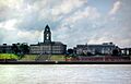
Wallasey became a County Borough in 1913. Its town hall officially opened in November 1920. The town's boundaries grew in 1928 to include Moreton and Saughall Massie.
On April 1, 1974, the County Borough of Wallasey became part of the Metropolitan Borough of Wirral. The town is in the parliamentary area called Wallasey. Since 1992, Angela Eagle from the Labour Party has been the MP for Wallasey.
Geography of Wallasey
Wallasey is located on the northeast side of the Wirral Peninsula. It's on the western bank of the River Mersey and next to the Irish Sea. The area is about 9.5 km (6 mi) east-northeast of the Dee Estuary at Hoylake. Wallasey is between 0 and 50 meters (0-164 ft) above sea level. The highest point is near St Peter and St Paul's Church in New Brighton.
 |
Liverpool Bay (Irish Sea) |
Formby (across Liverpool Bay) |
Bootle (across River Mersey) |
|
| Leasowe | Liverpool (across River Mersey) |
|||
| Bidston | Birkenhead | Liverpool (across River Mersey) |
Wallasey is made up of several different areas: Egremont, Liscard, New Brighton, Poulton, Seacombe, and Wallasey Village. These areas gradually joined together to form one large town in the 1800s and early 1900s.
Unlike many towns, Wallasey doesn't have just one town center. The main shopping area is in Liscard, which is centrally located. The parliamentary area and the former County Borough of Wallasey also include Leasowe, Moreton, and Saughall Massie. These are now usually seen as separate towns.
Wallasey is part of the larger Birkenhead Urban Area, which had a population of 325,000 in 2011.
Liscard Area

Liscard has the main shopping area in Wallasey. It includes the Cherry Tree precinct (a covered shopping area) and many shops along the streets. Central Park, which used to be the grounds of Liscard Hall, is the biggest park in the town. Most of Liscard is residential, with many semi-detached houses and some terraced homes. The old gatehouse from the Liscard Battery still stands.
Sadly, Liscard Hall was destroyed by a fire on July 7, 2008. The damage was so bad that the whole building had to be taken down.
Wallasey Village Area
Wallasey Village has a mix of houses, mostly semi-detached and detached homes built in the 1900s. It has a shopping street with a pretty floral roundabout in the middle. St Hilary's Church is a very old church. Only the old tower remains from a church built in 1530, which burned down in 1857. There are two railway stations here: Wallasey Village and Wallasey Grove Road. At the north end of Wallasey Village, the main street leads to the promenade and a coastal park, plus two golf courses. The promenade runs for over 7 miles (11 km) from the 'Gunsite' to Seacombe.
New Brighton Area

New Brighton was a very popular seaside resort after the mid-1800s. However, its popularity went down after the 1950s. Still, the marine promenade is part of a walking path, and the areas near the sea now have a much better beach and many fun activities. The Floral Pavilion hosts regular shows and famous performers. Vale Park is a public park. The homes here range from large villas near the sea to suburban semi-detached houses and some terraced homes. New Brighton has its own railway station.
Poulton Area
Poulton was originally a small village where people fished and farmed next to the Wallasey Pool. Its name comes from this location. It grew as the docks expanded, mainly becoming an industrial area with terraced housing.
Egremont Area
Egremont became a wealthy residential area in the early 1800s. It was named by Captain Askew, who built a house there in 1835. He named it after his birthplace in Cumberland.
Seacombe Area
Seacombe is the most southeastern part of Wallasey. It's famous for its Mersey Ferry terminal. Ferries regularly leave from here to Pier Head in Liverpool and Woodside in Birkenhead. During busy times, there's a direct ferry service to Liverpool for commuters. The rest of the day, the ferries offer a circular tour for tourists, visiting Birkenhead Woodside. Seacombe is the only remaining ferry terminal of the three that used to connect Wallasey. The others were Egremont Ferry and New Brighton Ferry. Seacombe Ferry is also the start of a 4-mile (6 km) long promenade. This path is mostly free of traffic and runs along the River Mersey past New Brighton.
Important local buildings include St Paul's Church, which stands on its own traffic island, and the ventilation tower for the Kingsway Tunnel with its huge fans. Like Poulton, Seacombe grew with homes for dockworkers and people in nearby industries. Many of the homes are terraced or owned by Magenta Housing. The Guinea Gap swimming baths are located between Seacombe and Egremont.
Education in Wallasey
When compared to the national average, Wallasey schools have slightly lower GCSE results. However, their 'A' Level results are above the national average.
Primary Schools
- Egremont Primary School
- Greenleas Primary School
- Kingsway Primary School
- Liscard Primary School
- Mount Primary School
- New Brighton Primary School
- Park Primary School
- Riverside Primary School
- St Albans Catholic Primary School
- St George's Primary School
- St Joseph's Catholic Primary School
- Saints Peter and Paul Catholic Primary School
- Somerville Primary School
Secondary Schools
- The Kingsway Academy (in Leasowe)
- The Mosslands School
- The Oldershaw Academy
- St Mary's Catholic College
- Weatherhead High School
- St Georges Secondary Modern School
Voluntary Aided Schools
- St Alban's Catholic Primary School
- St Joseph's Catholic Primary School
- Saints Peter and Paul Catholic Primary School
- St Mary's Catholic College
Media and News
Television
Local news and TV shows for Wallasey are provided by BBC North West and ITV Granada. The local TV station TalkLiverpool also broadcasts to the area. TV signals come from the Winter Hill TV transmitter and the Storeton relay transmitter.
Radio
Local radio stations include BBC Radio Merseyside, Heart North West, Capital North West & Wales, Smooth North West, Greatest Hits Radio Liverpool & The North West, InDemand Radio, and Wirral Wave Radio, which is a community station.
Newspapers
The local newspaper for the town is the Wirral Globe, which comes out on Wednesdays. The Liverpool Echo also covers news from the area.
Transport in Wallasey

Roads
Several important roads connect to Wallasey:
- The Kingsway Tunnel was opened by Queen Elizabeth II in 1971. Its route through Poulton leads to its entrance in Seacombe. This tunnel connects Wallasey with the center of Liverpool. It was even shown in the movie Harry Potter and the Deathly Hallows - Part 1.
- The M53 motorway starts in Poulton. It goes south through the middle of the Wirral Peninsula to Chester and connects to the M56 motorway, which continues to Manchester Airport.
- The North Wallasey Approach Road begins in Wallasey Village and ends in Bidston at junction 1 of the M53.
- Leasowe Road provides access to Leasowe and Moreton to the west, and to Wallasey Village to the east.
Railway
The town has three railway stations: New Brighton, Wallasey Village, and Wallasey Grove Road. Merseyrail runs electric trains to Liverpool Central on the Wirral line every 15 minutes during the day. This changes to every 30 minutes in the late evenings and on Sundays.
Buses
Bus services in Wallasey are mainly run by Arriva North West, Stagecoach Merseyside, and Al's Coaches. Routes connect Wallasey with nearby towns like Birkenhead, Leasowe, and Moreton. The 423 bus provides a regular service to Whitechapel, Liverpool.
Until 1969, Wallasey had its own bus service. It was known for its unusual "sea green and rich cream" color, which looked like two shades of yellow. People often called them the "yellow buses." Most bus routes started from the Seacombe Ferry terminal and left when the ferry arrived. This created a unique scene where many double-decker buses would all start moving at once, like a race, as passengers boarded.
Famous People from Wallasey
Many interesting people have come from Wallasey:
|
|
Images for kids
-
Wallasey Town Hall
See also
 In Spanish: Wallasey para niños
