
Formby facts for kids
Quick facts for kids Formby |
|
|---|---|
| Town | |
.JPG) Formby Town Centre |
|

Formby
|
|
| Population | 22,886 (2021) |
| OS grid reference | SD293074 |
| Civil parish |
|
| Metropolitan borough |
|
| Metropolitan county | |
| Region | |
| Country | England |
| Sovereign state | United Kingdom |
| Post town | LIVERPOOL |
| Postcode district | L37 |
| Dialling code | 01704 |
| Police | Merseyside |
| Fire | Merseyside |
| Ambulance | North West |
| EU Parliament | North West England |
| UK Parliament |
|

Formby is a town in England, located in Merseyside. It is part of the Metropolitan Borough of Sefton.
Long ago, Formby was part of Lancashire. It is mentioned in the Domesday Book from 1086. People used to fish for cockles and shrimp here. Formby is built near the Irish Sea coast.
Today, Formby is a popular place for people who work in Liverpool. It is also a great spot for tourists. Visitors love its beaches, sand dunes, and special wildlife. You can find endangered red squirrels and natterjack toads here. The National Trust helps protect this beautiful area. It is also a Site of Special Scientific Interest.
Contents
Discovering Formby's Past
The sand on Formby beach sometimes moves away. This reveals layers of mud and sediment from 5,000 to 8,000 years ago. These layers often show footprints of humans and animals. You can see prints from red deer, wild boar, and even wolves. In 2016, over 50 human footprints from 7,000 years ago were found.
What Does "Formby" Mean?
The name "Formby" comes from a Scandinavian word. -by means "homestead" or "village." The original name was Fornebei. This means "the old settlement" or "village belonging to Forni." Forni might have been a Viking leader.
Vikings Arrive in Formby
Around 960 AD, Vikings came to the west coast of Lancashire from Ireland. They first traded or raided, then settled. Some stories say Vikings could not beat the local Anglo-Saxons on the coast. So, they sailed up the River Alt and attacked from behind. A local road, Dangus Lane, is sometimes called Danesgate Land. This name is linked to the Viking invasion.
Formby Hall and Its History
Formby Hall is a very old building. It dates back to 1223. It was traditionally the home of the local lords. Much of the land around it is now a golf course.
UK's First Lifeboat Station
Formby Beach was home to the first lifeboat station in the UK. It might have started as early as 1776. This was set up by William Hutchinson. The last launch from this station was in 1916. You can still see the foundations of the old lifeboat station buildings on the beach. A pub in town is named 'The Lifeboat' to honor this history.
RAF Woodvale: A Local Airfield
RAF Woodvale is a small RAF station near Formby. It opened in 1941 during the Second World War. It was a fighter plane base. Today, it is used for light aircraft and fighter training. It was also home to the last Supermarine Spitfire to fly for the British military. The Woodvale Rally, a big show, is held here.
How Formby is Governed
Before 1974, Formby was its own urban district. Since 1974, it has been part of the Metropolitan Borough of Sefton. This is in Merseyside.
Formby is part of the Sefton Central area for national elections. The local MP is Bill Esterson. He is a member of the Labour Party.
For local elections, Formby is split into two areas. These are Harington ward and Ravenmeols ward. Each area has three councillors. Formby also has its own local council, the Formby Parish Council.
Formby's Geography

Formby is a coastal town. It covers about 7 square miles (17 km²). The town is built on a flat area called the West Lancashire Coastal Plain. The highest points in Formby are its sand dunes. These dunes are always changing shape.
The land between Formby and nearby towns is mostly green belt land. This means it is protected and used for farming. The soil in Formby is sandy and drains well.

The area between Formby and the coast has many different plants and animals. It has pine forests, sand dunes, and ponds. Large parts of this land are protected by the National Trust. The River Alt flows along the southern edge of the town. It enters the Irish Sea just south of Formby.
Formby has a temperate climate. This means it has mild winters and warm summers. The coastline faces ongoing erosion from the sea. To help stop this, discarded Christmas trees are sometimes planted in the dunes. This helps slow down the erosion.
Formby's Economy
The main shopping area is called 'The village'. It has many shops, including Boots and Card Factory. There are also independent stores. These shops are mostly on Chapel Lane and Brows Lane. You can also find coffee shops, banks, and charity shops here.
There are smaller shopping areas around Formby and Freshfield. These have convenience stores and specialist shops. Formby also has a main post office and two smaller ones.
The town has several supermarkets like Tesco and Waitrose. Formby does not have many large industries. There is a small industrial estate with a McDonald's. Many residents travel to Liverpool or Southport for work.
Tourism in Formby

Formby has a big tourist industry. Many people visit, especially from May to September. It is popular with day trippers from across the North West. There are two main spots along the Formby Coast that people love to visit.
The Lifeboat Road site is about 1.5 miles from the town center. It has car parks and paths leading to the sand dunes and woods. The car parks are about 900 yards from the beach.
Victoria Road is north of Lifeboat Road. It is often busier because of the red squirrel reserve. This is also where the asparagus trail starts. Parking is available here, and the beach is about 100 yards from the car park.
There is a privately run caravan park called Formby Point Caravan Park. It is open from March to October. There is also a smaller caravan site called Freshfield Caravan Park.
Getting Around Formby
The Formby Bypass (A565) was built in the 1930s. It helps traffic from Liverpool to Southport avoid the town center. It is a dual carriageway with roundabouts and traffic lights. The B5195 road connects Formby to Ormskirk. Motorways like the M58 and M57 are also easy to reach.
Train and Bus Services
Formby has two railway stations: Formby railway station and Freshfield railway station. Both are on the Northern Line of the Merseyrail network. Trains run often, usually every 15 minutes. They are a popular way to travel to Liverpool city center.
Bus services are provided by Arriva North West and Stagecoach. These buses go to Southport, Liverpool, and other local areas. There are also local circular routes.
Airports and Cycling
The closest commercial airport is Liverpool John Lennon Airport, about 17 miles away. Manchester Airport is 36 miles away. You can reach Liverpool Airport by train.
London is less than two hours away by train. You can catch a train from Runcorn or Liverpool Lime Street.
Formby also has great cycle routes. These mainly follow the pinewoods along the coast. They lead to both Southport and Liverpool. There are also many cycle lanes on the roads.
Schools in Formby
Formby has seven primary schools. These include Woodlands, Redgate CP, and Our Lady of Compassion RC. Trinity St Peter's C. of E. was formed by combining two older schools.
There are two large high schools in Formby: Formby High School and Range High School. There was also an independent school called Clarence House, but it closed in 2018.
Local Media
Local news and TV shows come from BBC North West and ITV Granada.
Local radio stations include BBC Radio Merseyside and Hits Radio Liverpool. There is also Dune Radio, a community station.
Formby is served by local newspapers like the Southport Visiter and the Liverpool Echo.
Scouting in Formby
Scouting has a long history in Formby, starting in 1909. This was soon after Baden Powell started the movement. The first Scout group was the 1st Formby. Today, several active groups continue the tradition. Scouts can be seen marching through the village every year on St George's Day.
Amazing Wildlife in Formby
To the west of Formby are pinewoods and sand dunes. This entire coastline is a Special Area of Conservation. It is managed for its important wildlife.
Red Squirrels
The pine woods at Victoria Road are a National Trust reserve for the red squirrel. Red squirrels are an endangered species. Formby is one of the few places in Britain where you can still find them. They are threatened by the grey squirrel.
Natterjack Toads
Formby is also known for its natterjack toads. It is one of the few places in England where they breed. In the evening, you can hear the male toad's special song. Locals sometimes call it the 'Bootle Organ'. In spring, males gather at shallow pools to sing and attract a mate.
Sports in Formby
The coast near Formby is famous for its golf courses. These include Southport & Ainsdale and Royal Birkdale. Formby has its own championship golf course, Formby Golf Club.
Formby also has a cricket club. It is based at Cricket Path in Freshfield. This club also has squash courts and a hockey pitch.
Football in Formby
Formby used to have a football team called Formby F.C.. They played at Altcar Road. Their old ground is now the Formby Pool, which opened in 2007. A big game for the club was in 1973 when they played Oldham Athletic in the F.A. Cup.
Youth Sports
Many youth sports groups are based in Formby. One is Formby Junior Sports Club (FJSC). It is known as "Rourke's League." Jim Rourke founded the club in 1959. Over 600 children play football there every Saturday morning. The club welcomes children of all abilities.
Formby is also home to Formby Dons Football Club. They have three teams. In 2007, the Formby Vikings Rugby Union Team was started.
Famous People from Formby
Many professional footballers and managers have lived in Formby. Most of them are linked to Liverpool FC or Everton FC.
Footballers and Managers
- Joe Allen
- Leighton Baines
- Alan Ball
- Mario Balotelli
- Ross Barkley
- Stig Inge Bjørnebye
- Fabio Borini
- Andy Carroll
- Ray Clemence
- Joe Cole
- Stewart Downing
- Fabinho
- David Fairclough
- Duncan Ferguson
- Steven Gerrard
- Joe Gomez
- Jordan Henderson
- Tony Hibbert
- Emlyn Hughes
- Sami Hyypiä
- Howard Kendall
- Jürgen Klopp (while Liverpool FC manager)
- Adam Lallana
- Rickie Lambert
- Yerry Mina
- Phil Neal
- Mike Newell
- Divock Origi
- Andrew Robertson
- Brendan Rodgers (while Liverpool FC manager)
- Wayne Rooney
- Neil Ruddock
- Gylfi Sigurðsson
- Alan Shearer (while at Blackburn Rovers)
- Raheem Sterling
- Alan Stubbs
- John Toshack
- Arne Slot
Other Notable People
- Beryl Bainbridge, English novelist
- John Birt, former director of the BBC
- Edward Craig, philosopher
- Tymon Dogg, musician
- Angela Eagle, Labour MP
- Maria Eagle, Labour MP
- Kevin McNamara, former Labour MP
- Chris Chibnall, television writer
- Percy French, Irish songwriter (buried in Formby)
- Thomas Fresh, public health pioneer
- John Garstang, archaeologist
- Christopher Hope, journalist
- Sir John Moores, founder of Littlewoods
- John Parrott, snooker player
- Andrew Sumner, movie journalist
- Rhian Teasdale, lead singer of Wet Leg
- Matt Williams, BBC sports broadcaster
The famous music hall entertainer George Formby Sr. took his stage name after seeing "Formby" on a train. His son, George Formby Jr., used the same stage name.
Images for kids
-
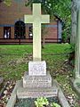
Grave of Percy French
-
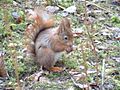
Red squirrel feeding
-
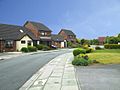
Housing in Formby
-
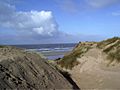
Formby Beach sand dunes
-
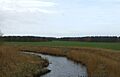
River Alt south of Formby


See also
 In Spanish: Formby para niños
