
1926 Nassau hurricane facts for kids
| Category 4 major hurricane (SSHWS/NWS) | |

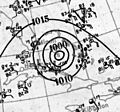
Surface weather analysis showing the hurricane over the Bahamas on July 26
|
|
| Formed | July 22, 1926 |
|---|---|
| Dissipated | August 2, 1926 |
| (Extratropical after July 31) | |
| Highest winds | 1-minute sustained: 140 mph (220 km/h) |
| Lowest pressure | < 967 mbar (hPa); 28.56 inHg |
| Fatalities | 287 direct |
| Damage | $7.85 million (1926 USD) |
| Areas affected | Lesser Antilles, Puerto Rico, Hispaniola, the Bahamas, Florida, Southeastern United States |
| Part of the 1926 Atlantic hurricane season | |
The 1926 Nassau hurricane, also known as the San Liborio hurricane or The Great Bahamas Hurricane of 1926, was a very strong Category 4 hurricane. It hit the Bahamas with its strongest winds. Even though it got weaker before reaching Florida, it was one of the most serious storms to hit Nassau, the capital of the Bahamas, and the island of New Providence. This storm also brought heavy rains and destroyed crops in the southeastern United States and Florida. It was a unique Category 4 hurricane because its central pressure was quite high for its wind speed.
Contents
How the Hurricane Formed and Traveled

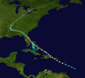
This powerful storm started as a weak tropical storm on July 22, 1926. It was first seen east of the Lesser Antilles. The storm moved northwest, passing near Dominica with winds of about 70 miles per hour (110 km/h). It then entered the eastern Caribbean Sea.
Growing Stronger
The storm became a hurricane on July 23. Soon after, it passed just south of Puerto Rico. It reached its first peak strength with winds of 105 miles per hour (169 km/h) before hitting Cabo Rojo early on July 24. In San Juan, winds reached about 66 miles per hour (106 km/h). The center of the hurricane, called the eye, passed near the southwest corner of Puerto Rico.
The storm continued northwest, passing east of Hispaniola. It lost some strength because of interacting with the land. By July 24, its winds dropped to 85 miles per hour (137 km/h). However, the storm quickly got stronger again as it moved over the Turks and Caicos Islands on July 25.
Reaching Peak Strength
The hurricane kept getting stronger. By July 25, it became a major hurricane. When it reached the central Bahamas on July 26, its winds were an amazing 140 miles per hour (230 km/h). Later that day, the storm hit New Providence island and passed over Nassau. Winds there were estimated to be around 135 miles per hour (217 km/h).
After passing New Providence, the storm slowed down and weakened a lot. By July 27, it was no longer a major hurricane. As it got closer to the Florida coast, it curved north-northwest. It passed just east of Cape Canaveral early on July 28. The hurricane then made landfall near Edgewater, Florida, with winds of 105 miles per hour (169 km/h).
Moving Inland
After hitting Florida, the storm curved northwest and quickly weakened as it moved inland. It became a tropical storm southwest of Jacksonville. On July 29, it moved across Georgia as a weakening tropical storm. It then entered Alabama as a tropical depression. The storm continued across the southeastern United States, losing its tropical features. It gradually curved northeast over Arkansas, Missouri, and the Ohio Valley. By August 1, it became an extratropical storm. It finally disappeared the next day as it moved northeast over Lake Ontario.
Impact of the Hurricane
This hurricane caused many problems and sadly, many people lost their lives. More than 287 people died in Puerto Rico, the Dominican Republic, the Bahamas, and Florida. In the Bahamas, the storm caused over 100 deaths. When combined with two other storms later that year, the total number of people who died in the Bahamas from hurricanes was over 300.
Puerto Rico and Hispaniola
When the storm passed near Puerto Rico, it caused a lot of damage to crops. Coffee plantations in the west-central part of the island were especially hard hit. Strong winds affected the whole island. All the rivers in the southern half of the island overflowed their banks. Heavy rainfall of about 6.18 inches (157 mm) fell on the island. About 25 people drowned because of the fast-rising floodwaters. The total damage in Puerto Rico was estimated at $2.35 million. This storm is known as the San Liborio hurricane in Puerto Rico. In eastern Santo Domingo, the storm caused about $3 million in damage as its center passed over the eastern part of Hispaniola.
The Bahamas
The hurricane caused a lot of damage across much of the central Bahamas.
- On Exuma Island, 500 homes were destroyed. This was 90% of all homes there.
- Roads and bridges were washed away.
- All unharvested crops, including the entire corn crop, were ruined.
- Dead farm animals were found everywhere.
- On Eleuthera, coconut and other fruit trees were knocked down.
- Strong winds and high tides destroyed 240 homes, 14 churches, and two schools on Eleuthera.
- Most roads on Eleuthera became unusable. The main causeways were washed out to sea, leaving 2 to 4 feet (0.61 to 1.22 m) of water covering the island.
- At least 74 people drowned on nearby Cat Island.
- Most homes on the Berry Islands were also destroyed.
- On Bimini, a lighthouse and a wireless station were ruined. Strong winds ripped roofs off several churches and other buildings.
After the storm, the crew of the USS Bay Spring brought over 1,000 tons (910,000 kg) of supplies and building materials to help the people. Nearby towns on Andros lost most or all of their buildings. In some areas, the storm ruined the sisal crop, knocked down 95% of the coconut trees, and destroyed stone buildings. Water was more than 5 feet (1.5 m) deep in some places.
The most significant damage happened on New Providence, especially in Nassau. Eyewitnesses said that "some roofs were torn off entirely" and the storm was "more fearful and devastating than any most people can remember." Trees, power poles, and other debris filled the streets. Many people lost their homes. Cars in Nassau were also damaged, and there was widespread flooding.
Florida
Areas near where the storm hit Florida also reported a lot of damage. Buildings, crops, and communication lines were badly affected, especially in New Smyrna Beach. Telephone and electricity services were disrupted in Daytona Beach. High tides destroyed businesses along the beach and sank boats.
Areas farther south along the Florida coast, like Miami, only got a small brush from the storm. This caused some rain and light wind damage, mostly to fruit crops. The Palm Beach area reported a lot of coastal flooding that damaged buildings near the coast. The storm also caused damage around Melbourne, where citrus trees were pulled up and roofs were blown off. An observer on Merritt Island reported a heavy storm surge along the Indian River. This surge damaged or destroyed homes, docks, and boats. A lot of rain fell in Florida during the storm, with Merritt Island getting over 10.08 inches (256 mm). The damage in Florida was estimated to be more than $2.5 million.
Hurricane Records
Before the very active 2005 Atlantic hurricane season, this 1926 hurricane was the strongest hurricane ever recorded in July. However, Hurricane Dennis in 2005, a strong Category 4 hurricane with winds of 150 miles per hour (240 km/h), later surpassed its intensity.
Images for kids
-
A weather map showing the hurricane over the Bahamas.
-
The path of the 1926 Nassau Hurricane.
