Anstey Hill Recreation Park facts for kids
Quick facts for kids Anstey Hill Recreation ParkSouth Australia |
|
|---|---|
|
IUCN Category III (Natural Monument)
|
|
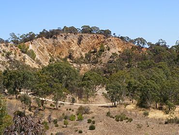
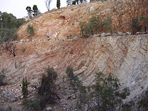
Quarry in the northwest of Anstey Hill Recreation Park
|
|
| Nearest town or city | Adelaide |
| Established | 31 August 1989 |
| Area | 3.62 km2 (1.4 sq mi) |
| Managing authorities | Department for Environment and Water |
| Website | Anstey Hill Recreation Park |
| See also | Protected areas of South Australia |
Anstey Hill Recreation Park is a special protected area in South Australia. It covers about 362 hectares (about 900 acres) and was created in 1989. You can find it about 19 kilometers (12 miles) northeast of Adelaide.
This park is an important area of natural bushland in the Mount Lofty Ranges foothills. It's home to rare plants and animals. The park is looked after by the City of Tea Tree Gully, the Department for Environment and Water, and a group of volunteers called The Friends of Anstey Hill. It's a great place for walking, but it doesn't have other visitor facilities.
The land for the park was bought by the government starting in 1966. At first, there were plans to use the area for businesses. But people wanted it to be a public park, so it was officially made a reserve in 1989. The last piece of land was added in 2003.
Anstey Hill is a peak in the park, standing 371 meters (1,217 feet) high. Both the hill and the park are named after a road built by an early farmer, George Alexander Anstey. The park often has bushfires, mostly started on purpose. There isn't much permanent water here, except for some springs in Water Gully. The land is very steep in many places.
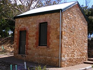
The Mannum–Adelaide pipeline runs through the park. A water treatment plant on the park's edge helps clean about 20% of Adelaide's drinking water. The park also has old ruins from its past uses, like Newman's Nursery, which was once a huge plant nursery. Ellis Cottage is one of the oldest homes in the area, and Rumps Bakery was the first bakery in Tea Tree Gully. Stone from the park's quarries was used to build famous buildings in Adelaide.
Contents
Exploring Anstey Hill Park Today
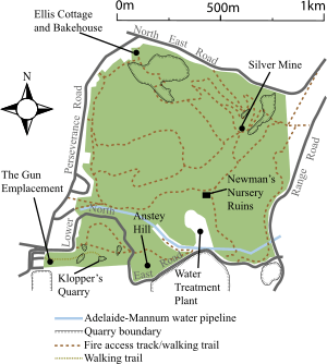
Anstey Hill Recreation Park is a public area with small creeks that dry up in summer, low hills, and steep valleys. It's located on the edge of the Mount Lofty Ranges foothills. This means you can see it from Adelaide. The park is about 19 kilometers (12 miles) northeast of Adelaide's city center. It covers parts of the suburbs of Tea Tree Gully, Vista, Highbury, and Houghton.
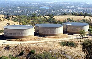
The Adelaide–Mannum water pipeline crosses the park's south. A water treatment plant is also located on its southern border. Anstey Hill itself is 371.1 meters (1,217.5 feet) above sea level. Next to the park's southern edge is the Anstey Hill Quarry, which produces white clay. There are also two large old quarries that are no longer used.
How the Park is Managed
The park is managed by the Department for Environment and Water, along with the local council and the volunteer group, The Friends of Anstey Hill. These volunteers do a lot of work. They help plant new trees, control weeds, fix old ruins, and create walking trails.
The park doesn't have many facilities for visitors. There are mostly walking trails that follow old fire tracks. One special path leads to Klopper's Quarry. Most of the park is a "conservation zone." This means you can enjoy quiet activities like walking, and you can even bring your dog if it's on a leash. Horses and motor vehicles are not allowed.
In 2006, there was a plan to allow mountain biking in certain areas of the park. This would create special tracks for bikes. The goal is to protect nature while also giving mountain bikers a place to ride. This helps stop illegal riding in other parts of the park.
Weather and Landscape
Anstey Hill Park gets an average of 580 to 820 millimeters (23 to 32 inches) of rain each year. Summers are hot and dry, with average daily temperatures around 28 to 29 °C (82 to 84 °F) from December to February. Winters are wetter and cooler, with July's average temperature around 14.6 °C (58.3 °F).
Most of the creeks in the park are seasonal, meaning they dry up for much of the year. Only the springs in Water Gully have water all the time. The park goes from about 220 meters (720 feet) above sea level on its west side to 420 meters (1,380 feet) at its highest point in the southeast. Much of the park is very steep. The soil is generally thin and doesn't have many plant nutrients, except at the bottom of Water Gully.
Bushfires in the Park
Bushfires happen often in the park. Large parts of the park burned in 1980, 1981, and during the big Ash Wednesday fires in 1983. In 2004, another major fire burned over 100 hectares (250 acres) of bushland.
Most fires in the park are started on purpose. The park is known as a "hotspot" for deliberate fires. This isn't new; records show fires being started on purpose as far back as 1869. On average, the park has more than one deliberate fire attack each year. Most of these fires start at the park's edges and stay within the park.
Park's Geology and Rocks
The park's hills and steep slopes were formed by land moving along the Burnside-Eden fault zone. This fault separates the Adelaide Plains from the Mount Lofty Ranges. It runs across the park from its southwest corner.
The rocks under the park are very old, formed about 700 million years ago from sand washed into a shallow sea. These sand layers were later folded and changed into harder rock during a period of mountain building. This created a mountain range where the Mount Lofty Ranges are today, about 450 million years ago. Over millions of years, this range wore down to a flat plain. Then, about 2 million years ago, the Mount Lofty Ranges were lifted up again by block faulting.
The Gun Emplacement is a small part of this very old, flat land surface that wasn't eroded away. It's a raised, flat area in the park's southwest corner with great views of Adelaide. It's important for understanding how Adelaide's landscape changed over time. It was named a Geological Monument in 1978.
Different types of rocks can be seen across the park. The youngest is Stoneyfell quartzite, which is mostly quartzite with some sandstone. Older is Woolshed flat shale, made of siltstone and dolomite. The oldest rock regularly seen is Montacute dolomite, a blue-grey dolomite. Quarries in the park's south mined Stoneyfell Quartzite. This rock has ripple marks, showing it formed in shallow water.
Near Newman's Nursery, there's a quarry with blue dolomite used for road material. The largest quarry in the park has Tea Tree Gully freestone, a type of sandstone used for building. This stone was easy to cut and shape. The Tea Tree Gully iron mine is in an area rich in iron. It's mainly limonite and silica.
Plants and Animals of Anstey Hill
In 1983, experts found 413 plant species in the park, with 124 of them not native to the area. By 2006, the list had 411 species, and 107 were non-native. Five native plant species were noted as rare or vulnerable, like the pale leek-orchid.
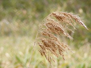
The park has many pink gums and long-leafed box trees. Other common plants include button daisy, pussy tail, needlebush, silky guinea flower, and black rapier sedge. Black-boys (Xanthorrhoea), hop bush, and tea-tree grow underneath the taller trees in some parts. The area around Newman's Nursery ruins is known for its beautiful orchid display in spring.
Controlling Invasive Plants
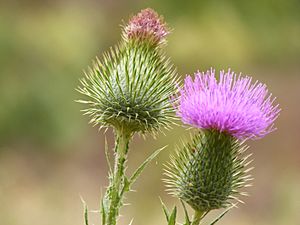
Invasive weeds are a big problem in the park. They can harm the native plants. Some of the most concerning weeds are bridal creeper, boneseed, artichoke thistle, different types of broom, Spanish heath, fennel, olives, blackberries, common gorse, and dog rose. In 2001, a plant disease called Phytophthora cinnamomi was found. To stop it from spreading, the park has boot scrubbing stations for visitors.
Animals in the Park
Experts expected to find 145 bird species in the park. By 2006, 98 species had been recorded. Seven insect species found in the park are unusual because they are mostly found in dry areas, not usually near Adelaide. About 35 types of reptiles and amphibians have been seen in the park.
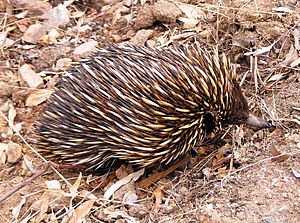
Animals living in the park include western grey kangaroos, common ringtail possums, common brushtail possums, short-beaked echidnas, and several types of bats. Koalas are also present, but they were brought to the Adelaide hills by people and are not native to this area.
Introduced Animals
Like many places in Adelaide, the park also has animals that are not native. These include red foxes, cats, European rabbits, black rats, house mice, and European hares. Common introduced birds are rock pigeons, European goldfinch, house sparrow, starlings, and blackbirds. Introduced bees and aggressive European wasps are also found in the park.
How Anstey Hill Got Its Name
The park is named after a road built by George Alexander Anstey. He was an early farmer and gardener in South Australia. Anstey bought land in 1840 and built a private road to his property. This road went along a gully and up a steep hill. It was first called "Anstey Hill Road," and this name was later used for the hill and then the park.
The "Gun Emplacement" was officially named in 1997. This name was first used by Major William Hubert Edmunds, a mapmaker who served in the Boer War. He noticed a unique flat area near what is now Tea Tree Gully. By 1926, he had named it "The Gun Emplacement," probably because it looked like a good spot for a field gun battery.
Creating the Park
In 1962, a report suggested creating a regional park near Anstey Hill. The idea was to protect the natural look of the foothills, which are visible from Adelaide. From 1966 to 1977, the government bought land for what was then called "reserve 13."
One big purchase in 1969 included 16 hectares (40 acres) of an active quarry. This quarry, called the Tea Tree Gully freestone quarry, is now in the park's northwest. It operated until 1982. The land under the Gun Emplacement was planned for housing in 1966. However, a developer's attempt to divide the plateau for houses in 1975 failed. The government bought this site in 1978 and added it to the Anstey Hill Reserve.
During the 1970s, parts of the park were still planned for housing. But many groups, like the Geological Society of Australia and the National Trust of South Australia, strongly opposed this. They argued that the land was important for its history and science.
In 1981, a committee was formed to plan the park's development. A draft report suggested spending up to $3.5 million to create the park. Ideas included a rock climbing area, a motocross track, a kiosk, a cycle track, horse riding areas, camping grounds, and a restaurant. In 1983, the final plan was published. It even suggested a caravan park or a velodrome.
However, more and more people opposed these commercial ideas. This public pressure led to the entire area being declared a public recreation park. The volunteer group, Friends of Anstey Hill Recreation Park, was formed in 1990. Most of the park was officially opened on August 31, 1989. A smaller part was added in 2001, and the last section in 2003.
Past Uses of the Land
Even though the land is part of the traditional lands of the Aboriginal Kaurna people, no ancient living sites have been found. After European settlement, much of the park's land was used for farming. Important European uses included Newman's Nursery, a main road, mines, quarries, and a water treatment plant.
Newman's Nursery: A Giant Plant Farm
The ruins of Newman's Nursery are located in the park, at the bottom of Water Gully. Charles Newman and his family started this nursery in the mid-1800s. Charles bought land in 1854, which included Water Gully with its creek and permanent springs. The family built their first house there by 1855. They kept buying more land, and by 1885, their property was huge, covering 469 acres (190 hectares).
The Newmans developed the nursery between 1857 and 1871, with help from their 17 children! By 1870, they had hothouses. The nursery grew to be the largest in the southern hemisphere. In 1889, they had over 100,000 orange trees, 100,000 grapevines, and 500,000 other fruit trees. They grew 300 types of orchids, 350 types of chrysanthemums, and 700 types of roses. The nursery won many awards at agricultural fairs.
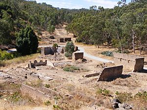
Charles Newman died in 1889, and his son Frederick took over. In 1913, two severe storms badly damaged the nursery. It never fully recovered. Frederick left in 1925, and the original nursery was sold in 1932. The new owners removed everything valuable. Most of the remaining plants were destroyed by bushfires during Ash Wednesday in 1983. Today, only the foundations and walls of Newman's Nursery remain. They are listed on the State Heritage Register.
Mining and Quarrying History
Dolomite, sandstone, and quartzite rock were mined a lot in the park. While small amounts of silver, copper, and gold were found, they weren't enough to be profitable. The park has many quarries. The biggest one is an open-cut quarry in the northwest. It operated until 1982, providing stone for buildings like Adelaide's war memorial and St Peter's Cathedral. Stone from these quarries was used for many of Adelaide's Victorian-era public buildings, including the Adelaide Town Hall and the General Post Office.
An ironstone mine opened in 1853 to supply material for copper smelting works, but it closed quickly. It reopened briefly in 1861. The Tea Tree Gully Silver Mining Company started work in 1888 but closed in 1889 because they didn't find enough silver. Quarries in Water Gully provided blue dolomite for the nursery buildings and quartzite for road material.
When the park was created, existing mining rights were allowed to continue. However, strict rules make it unlikely that mining will happen in the future.
Klopper's Quarries and the Arts
Klopper's quarries, in the park's south, were mined in the late 1800s and early 1900s. Heinrich Kloepper, who arrived from Germany in 1847, opened his first quarry in 1850. These quarries supplied material for building roads and bluestone for home and road kerbs. After Klopper died in 1888, his family continued the business.
The freestone quarry was used to host plays for the Adelaide Festival of Arts. It could seat about 800 people, and its 20-meter (66-foot) high rock face made a great backdrop. Three plays were performed there in the 1980 festival. In 1988, a nine-hour production of the Mahābhārata was performed by a famous theatre company.
Ellis Cottage and Rumps Bakery
The historic Ellis Cottage and Rumps Bakery buildings are near the corner of Perseverance and North East roads. Ellis Cottage was built in 1854 by John Stevens. It was named after the Ellis family, who used it for storage until World War II.
Rumps Bakery was also built in 1854 using local stone. From 1867 to 1893, Charles Rumps rented it and started Tea Tree Gully's first bakery there in 1872. The building was later used for storage by the Ellis family and a nearby general store. In 2000, volunteers from the Friends of Anstey Hill helped stabilize both buildings.
Water Filtration Plant
In the 1970s, an area at the top of the park was chosen for a water treatment plant. This site was good because it was stable and didn't need a major pumping station. The plant was built so it couldn't be seen from Adelaide. It started working in 1980 and cleans water from the Mannum to Adelaide pipeline. It was the second such plant in Adelaide. Most of the water comes from the River Murray, but some comes from Millbrook Reservoir.
The plant was designed to supply water to 70,000 homes in Adelaide's outer northeastern suburbs. It cost $14.5 million to build. As of 2005, the plant filters about 20% of Adelaide's water supply. A small hydroelectric plant also started operating nearby in 2003. It uses the force of water flowing down Anstey Hill to create electricity.
Roads Through the Park
Lower North East Road runs around Anstey Hill. It connects the towns of Hope Valley and Houghton. Three roads were built to connect these places. The first was a private road built by George Anstey in 1841. It went straight up Anstey Hill. From 1842 to 1846, Anstey built a new private road with a "devil's elbow" (a double hairpin bend) that followed the land's curves better. This road became known as Anstey Hill Road.
New Road, later called Lower North East Road, was built in 1873 as a replacement. It was longer but had a more even slope. It was paved in 1930. This road now separates a small part of the park, which contains Klopper's quarries and the Gun Emplacement, from the rest. You can still see parts of the two older roads near Klopper's quarries.
Perseverance Road defines much of the park's western edge. William Haines, a local clerk and politician, pushed for this road to be built from 1862. The road was finally approved and opened in 1880. It was officially named Haines' Perseverance Road.
 | Emma Amos |
 | Edward Mitchell Bannister |
 | Larry D. Alexander |
 | Ernie Barnes |


