
Bätterkinden facts for kids
Quick facts for kids
Bätterkinden
|
||
|---|---|---|

Bätterkinden village church
|
||
|
||

Bätterkinden
Location in Switzerland

Bätterkinden
Location in Canton of Bern
|
||
| Country | Switzerland | |
| Canton | Bern | |
| District | Emmental | |
| Area | ||
| • Total | 10.19 km2 (3.93 sq mi) | |
| Elevation | 473 m (1,552 ft) | |
| Population
(Dec 2020 )
|
||
| • Total | 3,288 | |
| • Density | 322.67/km2 (835.7/sq mi) | |
| Postal code |
3315
|
|
| Localities | Bätterkinden, Kräiligen, Alp, Holzhäusern, Berchtoldshof, Buuchi, Studenacher, Löffelhof, Neumatt, Niedermatt, Rütti | |
| Surrounded by | Aefligen, Fraubrunnen, Limpach, Schalunen, Utzenstorf, Wiler bei Utzenstorf, and Zielebach (Canton of Bern); Aetingen, Biberist, Gerlafingen, Küttigkofen, Kyburg-Buchegg, Lohn-Ammannsegg, and Lüterkofen (Canton of Solothurn) | |

Bätterkinden is a small town, also called a municipality, in Switzerland. It is located in the Emmental area of the canton of Bern. Bätterkinden is about 20 kilometers (12 miles) north of Bern, the capital city of Switzerland.
Contents
- A Look Back: Bätterkinden's History
- Exploring Bätterkinden's Geography
- What Does Bätterkinden's Coat of Arms Mean?
- Who Lives in Bätterkinden? (Demographics)
- Important Buildings: Heritage Sites
- Bätterkinden's Economy
- Religion in Bätterkinden
- Learning in Bätterkinden: Education
- Getting Around: Transportation
- Famous People from Bätterkinden
- Images for kids
- See also
A Look Back: Bätterkinden's History

Bätterkinden was first written about in the year 1261. Back then, it was called Beturchingen.
During the Middle Ages, there was a settlement on a hill called Zwingherrenhubel. By 1261, Bätterkinden was part of the Kyburg Amt (which was like a local district) of Utzenstorf. In 1406, the Kyburg family gave Bätterkinden to Heinrich Ringoltingen. This was to pay off some of their debts. He then combined Bätterkinden and Utzenstorf into a larger area called the Herrschaft of Landshut. In 1510, Bern took control of Bätterkinden, and a few years later, the rest of the Landshut area.
After the French invaded Switzerland in 1798, Bätterkinden became part of the Burgdorf district in the Helvetic Republic. This was a new government set up by the French. In 1803, after the Act of Mediation (a new Swiss constitution), Bätterkinden moved to the Fraubrunnen district. The village faced a big fire in 1882, which destroyed many buildings. It was then rebuilt. A new neighborhood called Zelgli was built in 1979.
The village church was first mentioned in 1275. This church and a farm were originally owned by the Buchegg Herrschaft. In 1399, the church and its lands were given to a hospice (a type of care home) in Bern. Later, in 1595, the church was managed by the bailiff (a local official) in Landshut. The old church building was replaced with a new one in 1664.
During the 1700s and 1800s, farmers in Bätterkinden started growing new crops like potatoes and sugar beets. They also began raising more cattle, in addition to their traditional grain farming. To support these new dairy farmers, a dairy was built in Bätterkinden in 1848. Another one opened in Krailigen in 1867. An agricultural cooperative (a group of farmers working together) was started in 1897. Bätterkinden was once on a main highway between Bern and Solothurn. It even had a toll station in Krailigen. However, now major roads go around the village. Even though there's a train station and a bridge over the Emme river, not many big industries settled here. A wood pulp factory opened in 1865. It later became a paper mill in 1893 but closed in 1930. In 1921, a gravel factory opened, which later became a concrete factory in 1974. A factory making metal parts opened in 1949. While some people work in local industries or farming, most workers (over two-thirds in 1990) travel to jobs in Bern. The local secondary school started as a private school in 1846.
Exploring Bätterkinden's Geography
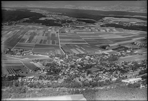
_148.JPG)
Bätterkinden covers an area of about 10.19 square kilometers (3.93 square miles). A large part of this land, about 57.8%, is used for farming. Forests cover about 24.1% of the area. The rest of the land, about 15.4%, is developed with buildings and roads. A small part, 2.1%, is made up of rivers or lakes.
Over the last 20 years (from 1979/85 to 2004/09), the amount of developed land in Bätterkinden has grown by 52 hectares (128 acres). At the same time, the amount of land used for farming has decreased by the same amount.
Within the developed areas, industrial buildings make up 1.7% of the total. Homes and other buildings are 7.6%, and roads and transportation areas are 2.8%. Parks, green spaces, and sports fields make up 2.9%. All the forested land is covered with dense forests. For farming land, 50.7% is used for growing crops, and 6.4% is used for pastures where animals graze. All the water in the town is flowing water, like rivers.
Bätterkinden is located west of the Emme and Urtenen rivers. The Limpach river also flows through it. The town includes the main villages of Bätterkinden and Kräiligen. It also has smaller settlements called hamlets like Alp, Holzhäusern, and Berchtoldshof, along with many scattered farmhouses. The municipality stretches about 7.4 kilometers (4.6 miles) from north to south.
On December 31, 2009, the old district of Amtsbezirk Fraubrunnen, where Bätterkinden used to belong, was closed down. The very next day, January 1, 2010, Bätterkinden became part of the new Verwaltungskreis Emmental district.
What Does Bätterkinden's Coat of Arms Mean?
The blazon (official description) of Bätterkinden's coat of arms says: Gules an Ear Or and in Chief of the last three Pales wavy Azure. This means it has a red background. On it, there is a golden ear of grain. At the top, there are three wavy blue stripes on a golden background.
Who Lives in Bätterkinden? (Demographics)
Bätterkinden has a population of about 3,300 people. As of 2013, about 6.6% of the people living here are foreign nationals. Over the last three years (2010-2013), the population has stayed mostly the same. In 2013, the birth rate was 10.8 births per thousand residents, and the death rate was 8.3 deaths per thousand residents.
Most people in Bätterkinden (about 94.9% in 2000) speak German as their first language. Albanian is the second most common language (0.8%), followed by Italian (0.6%). A few people also speak French or Romansh.
In 2008, about 47.8% of the population was male and 52.2% was female. Most residents are Swiss citizens. In 2000, about 28.7% of the people were born in Bätterkinden and still lived there. Many others were born in the same canton (38.8%) or elsewhere in Switzerland (20.6%). About 8.5% were born outside Switzerland.
As of 2013, children and teenagers (ages 0-19) make up 20.9% of the population. Adults (ages 20-64) are 61.8%, and seniors (over 64) are 17.3%.
In 2000, there were 1,086 single people who had never been married. There were 1,378 married people, 123 widows or widowers, and 113 divorced people.
In 2000, there were 264 households with only one person and 80 households with five or more people. Most apartments (95.5%) were lived in all the time. In 2013, there were 1,325 private homes in Bätterkinden. In 2000, about 66.3% of the buildings were single-family homes. About 15.9% of the buildings were built before 1919, and 11.5% were built between 1991 and 2000. In 2014, about 1.64% of homes were empty.
The chart below shows how the population of Bätterkinden has changed over time:

Important Buildings: Heritage Sites
The farm house at Solothurnstrasse 39 and the village church at Bernstrasse 15 are listed as important heritage sites in Switzerland. This means they are special buildings that are protected because of their history and importance.
-
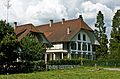
Farm house at Solothurnstrasse 39
-
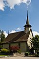
Village church at Bernstrasse 15


Bätterkinden's Economy

In 2011, Bätterkinden had an unemployment rate of 2.85%, which means a small number of people looking for jobs couldn't find one. In 2008, there were 751 people working in the town.
Jobs are usually divided into three main types:
- Primary sector: This includes jobs that get raw materials from nature, like farming, fishing, and forestry. In Bätterkinden, 87 people worked in this sector, with about 25 businesses.
- Secondary sector: These jobs involve making things, like in factories or construction. There were 217 people working in this sector, with 27 businesses. About half of these jobs were in manufacturing, and many others were in construction.
- Tertiary sector: These jobs provide services, like shops, hospitals, or schools. There were 447 people working in this sector, with 71 businesses. Many of these jobs were in sales, transportation, hotels, restaurants, education, and healthcare.
In 2008, there were 604 full-time equivalent jobs. This means if you add up all the hours worked, it would be like 604 people working full-time. Of all the people working in Bätterkinden, about 43.9% were women.
In 2000, 306 workers came into Bätterkinden for their jobs, while 1,075 workers left Bätterkinden to work somewhere else. This means more people leave Bätterkinden for work than come in. About 25.7% of working people used public transportation to get to work, and 46.8% used a private car.
Religion in Bätterkinden
Based on the 2000 census, about 12.1% of the people in Bätterkinden were Roman Catholic. A larger group, about 71.5%, belonged to the Swiss Reformed Church (a type of Protestant church).
A smaller number of people belonged to other Christian churches, including Orthodox and Christian Catholic. There were also people who followed Islam (about 1.81%), Buddhism, and Hinduism. About 7.04% of the population said they didn't belong to any church or were agnostic (not sure about God) or atheist (don't believe in God).
Learning in Bätterkinden: Education
In Bätterkinden, about 41.3% of the population has finished non-mandatory upper secondary education (like high school). About 11.2% have gone on to higher education, either at a university or a Fachhochschule (a type of technical university).
The school system in the Canton of Bern starts with one year of optional Kindergarten. After that, students go to six years of Primary school. Then, there are three years of lower Secondary school, where students are grouped based on their abilities. After lower Secondary, students can choose to continue their education or start an apprenticeship (learning a trade on the job).
During the 2010-2011 school year, 383 students attended classes in Bätterkinden.
- There were 3 kindergarten classes with 61 students.
- There were 11 primary classes with 224 students.
- There were 7 lower secondary classes with 98 students.
A small percentage of students in all levels were not Swiss citizens or spoke a different language at home than the classroom language.
In 2000, 23 students from other towns came to school in Bätterkinden. At the same time, 108 students from Bätterkinden went to schools outside the town.
Bätterkinden has a library called Bibliothek Bätterkinden. In 2008, the library had 10,330 books and other media. It loaned out 23,261 items that year. The library was open 198 days a year, for an average of 8 hours per week.
Getting Around: Transportation
Bätterkinden is a stop on the Regionalverkehr Bern-Solothurn (RBS) train line. Trains usually run every half-hour. It takes about 12 minutes to reach Solothurn and 26 minutes to reach Bern by train. There are also bus connections available.
Two main canton (state) roads cross in Bätterkinden. One is the T12 road, which goes from Solothurn to Bern (north to south). The other road connects Lyss to Utzenstorf and then to Koppigen or Burgdorf (east to west). There is also a canton road that connects Bätterkinden to Bucheggberg via Kyburg.
The A1 highway entrances, Kirchberg (towards Bern) and Kriegstetten (towards Basel and Zürich), can both be reached in about a 10-minute drive.
Famous People from Bätterkinden
- Florian Ast (born 1975 in Solothurn): A rock musician.
- Jeremias Lorza (born 1757 in Silvaplana, died 1837 in Bätterkinden): A theologian (someone who studies religion).
- Benedictus Aretius (born 1522 in Bätterkinden, died 1574 in Bern): A theologian, teacher, geographer, and reformer.
Images for kids
-
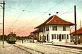
Post card showing Elektrischen Schmalspurbahn Solothurn-Bern (ESB, now RBS) trolley station in Bätterkinden in 1916.
See also
 In Spanish: Bätterkinden para niños
