Caddo County, Oklahoma facts for kids
Quick facts for kids
Caddo County
|
|
|---|---|

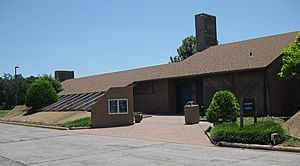
The Southern Plains Indian Museum in Anadarko
|
|

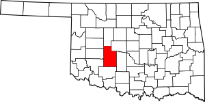
Location within the U.S. state of Oklahoma
|
|
 Oklahoma's location within the U.S. |
|
| Country | |
| State | |
| Founded | August 6, 1901 |
| Named for | Caddo Tribe |
| Seat | Anadarko |
| Largest city | Anadarko |
| Area | |
| • Total | 1,290 sq mi (3,300 km2) |
| • Land | 1,278 sq mi (3,310 km2) |
| • Water | 12 sq mi (30 km2) 0.9%% |
| Population
(2020)
|
|
| • Total | 26,945 |
| • Density | 20.89/sq mi (8.065/km2) |
| Time zone | UTC−6 (Central) |
| • Summer (DST) | UTC−5 (CDT) |
| Congressional district | 3rd |
Caddo County is a county in the state of Oklahoma. In 2020, about 26,945 people lived there. Its main town, or county seat, is Anadarko.
The county was created in 1901. It was part of Oklahoma Territory back then. Caddo County is named after the Caddo tribe. This tribe settled on a reservation here in the 1870s. Caddo County is just west of the bigger Oklahoma City area. Even though it's not officially part of the metro area, it has strong economic ties to it.
Contents
History of Caddo County
Caddo County started on August 6, 1901. This happened when the government divided the lands of the Kiowa, Comanche, and Arapaho tribes. The extra land was then sold to new settlers.
This reservation land was part of Oklahoma Territory. Oklahoma became a state on November 16, 1907. Some of Caddo County's land was used to create Grady County at that time. More land was given to Grady County in 1911.
Farming has always been very important to the local economy. Early main crops included cotton, corn, and wheat. Growing poultry and raising livestock were also key. By 1960, Caddo County was a top producer in Oklahoma. It led in peanuts, hogs, and poultry.
The first oil field, called Cement Field, was found in 1911. Oil production has been important ever since. There were also smaller oil booms in the 1960s, 1970s, and 1980s.
Geography and Nature
Caddo County covers about 1,290 square miles. Most of this area is land, about 1,278 square miles. The rest, about 12 square miles, is water.
The county mostly has rolling hills and plains. These are known as the Gypsum Hills and Red Bed plains. A small part in the southwest is in the Wichita Mountains. The Washita River and other creeks flow through the county.
Important lakes include Chickasha Lake and Fort Cobb Lake. Red Rock Canyon State Park is also in the county. It's special because it has the only natural stand of Caddo maple trees.
Neighboring Counties
Caddo County shares borders with several other counties:
- Blaine County (north)
- Canadian County (northeast)
- Grady County (east)
- Comanche County (south)
- Kiowa County (southwest)
- Washita County (west)
- Custer County (northwest)
People of Caddo County
| Historical population | |||
|---|---|---|---|
| Census | Pop. | %± | |
| 1910 | 35,685 | — | |
| 1920 | 34,207 | −4.1% | |
| 1930 | 50,779 | 48.4% | |
| 1940 | 41,567 | −18.1% | |
| 1950 | 34,913 | −16.0% | |
| 1960 | 28,621 | −18.0% | |
| 1970 | 28,931 | 1.1% | |
| 1980 | 30,905 | 6.8% | |
| 1990 | 29,550 | −4.4% | |
| 2000 | 30,150 | 2.0% | |
| 2010 | 29,600 | −1.8% | |
| 2020 | 26,945 | −9.0% | |
| 2021 (est.) | 26,368 | −10.9% | |
| U.S. Decennial Census 1790-1960 1900-1990 1990-2000 2010 |
|||
In 2000, there were 30,150 people living in Caddo County. About 24% of the people were Native American. By 2020, the population had gone down to 26,945.
Many households had children under 18. The average household had about 2.6 people. The average family had about 3.1 people. The median age in the county was 36 years old.
Economy and Jobs
Caddo County is known for its cattle ranches. It also has large wheat and peanut farms. Some farmers use special methods to protect the environment. These methods include "no-till" farming.
There is also one winery and vineyard in the county. It is called Woods and Waters Winery and Vineyard.
Towns and Communities
City
- Anadarko (This is the county seat)
Towns
Unincorporated Communities
These are smaller places without their own local government.
Education
Caddo County has many public school districts. These include:
- Anadarko Public Schools
- Binger-Oney Public Schools
- Boone-Apache Public Schools
- Carnegie Public Schools
- Cement Public Schools
- Cordell Public Schools
- Cyril Public Schools
- Fletcher Public Schools
- Fort Cobb-Broxton Schools
- Gracemont Public Schools
- Hinton Public Schools
- Hydro-Eakly Public Schools
- Lookeba-Sickles Public Schools
- Minco Public Schools
- Verden Public Schools
- Pioneer Public School (This is an elementary school only)
There is also a special school called Riverside Indian School. It is run by the Bureau of Indian Education.
Historic Places
Many places in Caddo County are listed on the National Register of Historic Places. This means they are important historical sites.
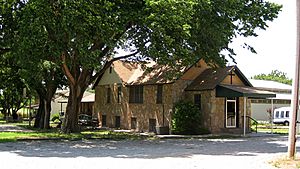
- Amphlett Brothers Drug and Jewelry Store, Apache
- Anadarko Armory, Anadarko
- Anadarko Downtown Historic District, Anadarko
- Apache State Bank, Apache
- Bridgeport Bridge, Bridgeport
- Bridgeport Hill-Hydro Route 66 Segment, Hydro
- Caddo County Medicine Creek Archeological District Binger
- First Baptist Church (Colored), Anadarko
- Fort Cobb Site, Fort Cobb
- Provine Service Station, Hydro
- Randlett Park, Anadarko
- Rock Island Passenger Station, Anadarko
- Rock Mary, Hinton
- Stevens Rock Shelter, Gracemont
See also
 In Spanish: Condado de Caddo para niños


