
Ceredigion facts for kids
Quick facts for kids
Ceredigion
|
|||
|---|---|---|---|
|
County
|
|||
 |
|||
|
|||
 |
|||
| Sovereign state | |||
| Country | |||
| Preserved county | Dyfed | ||
| Established | 1 April 1996 | ||
| Admin HQ | Aberaeron and Aberystwyth | ||
| Largest town | Aberystwyth | ||
| Government | |||
| • Type | Ceredigion County Council | ||
| Area | |||
| • Total | 1,783 km2 (688 sq mi) | ||
| Area rank | Ranked 4th | ||
| Population
(2015)
|
|||
| • Total | 74,600 | ||
| • Rank | Ranked 19th | ||
| • Density | 41/km2 (110/sq mi) | ||
| • Density rank | Ranked 21st | ||
| • Ethnicity | 99.5% White | ||
| Welsh language | |||
| • Rank | Ranked 3rd | ||
| • Speakers | 45.3% | ||
| Geocode | 00NQ (ONS) W06000008 (GSS) |
||
| ISO 3166 code | GB-CGN | ||


Ceredigion is a beautiful county located in the west of Wales. It's known for its stunning coastline along Cardigan Bay and its rolling hills that lead up to the Cambrian Mountains. Ceredigion is bordered by Gwynedd to the north, Powys to the east, and Carmarthenshire and Pembrokeshire to the south.
The largest town in Ceredigion is Aberystwyth. It shares the role of administrative center with Aberaeron. The county is home to about 71,500 people and is one of the least crowded areas in Wales. It's a special place for Welsh culture, with almost half of its residents speaking the Welsh language.
Ceredigion's coastline stretches for about 50 miles (80 km). Inland, the landscape becomes hilly, reaching its highest point at Plynlimon (752 meters or 2,467 feet) in the Cambrian Mountains. Many rivers start here, including the Rheidol, Ystwyth, Aeron, and Teifi. The Teifi River forms part of the border with Carmarthenshire and Pembrokeshire.
The county gets its name from an old kingdom called Ceredigion, which existed here around the 5th century. Later, in 1282, the English king Edward I established the area as Cardiganshire. In the past, Ceredigion was more industrial, with mines for lead, silver, and zinc. Today, its economy relies on dairy farming and a growing tourism industry. It's also an important place for learning, home to the National Library of Wales and parts of Aberystwyth University and the University of Wales Trinity Saint David.
Contents
History of Ceredigion
Ceredigion has a long and interesting history, with people living here since ancient times.
Early Settlements and Roman Times
- Many hill forts and ancient enclosures have been found across the county.
- There are also many standing stones from the Bronze Age.
- When the Romans came to Britain, this area was between two tribes, the Demetae and the Ordovices.
- A Roman road called Sarn Helen passed through Ceredigion.
- Roman forts were built at places like Bremia to protect gold mines.
Kingdoms and Monasteries
- After the Romans left, a leader named Cunedda supposedly helped defend the area from invaders.
- His son, Ceredig, is said to have settled the area in the 5th century, giving the county its name.
- For a time, Ceredigion was a small kingdom.
- Later, it became part of larger Welsh kingdoms like Deheubarth.
- Many pilgrims traveled through Cardiganshire on their way to St Davids.
- Important religious and learning centers included Strata Florida Abbey and Llanbadarn Fawr.
From Cardiganshire to Ceredigion
- In 1282, King Edward I of England conquered Wales and divided the land into counties.
- Cardiganshire became one of the thirteen traditional counties.
- In the 18th century, a religious revival led to many nonconformist chapels being built.
- Cardigan was once a major port in South Wales.
- However, the Industrial Revolution didn't affect the area much.
- Many people left the county in the 19th century to find work elsewhere or moved to other countries.
- The arrival of the railway in the 1860s brought more visitors to places like Aberystwyth.
- In 1974, the area became a district called Ceredigion.
- Since 1996, it has been known as the county of Ceredigion.
- The Welsh language is still very strong here, with 45.3% of people speaking it in 2021.
Geography of Ceredigion
Ceredigion is a county with diverse landscapes, from its long coastline to its mountainous interior.
Coastline and Rivers
- Ceredigion has about 50 miles (80 km) of coastline along Cardigan Bay.
- Its beaches are beautiful, and many have won awards for their quality.
- The county is one of only two places in the UK where you can see bottlenose dolphins living permanently.
- The Ceredigion Coast Path is a popular walking route along the coast.
- The Cambrian Mountains cover much of the eastern part of the county.
- The highest point is Plynlimon, a mountain that is 752 meters (2,467 feet) tall.
- Several rivers start in these mountains, including the Severn and the Wye.
- The River Teifi is the largest river and forms part of the county's southern border.
- Other important rivers are the River Aeron and the River Ystwyth.
Towns and Wildlife
- The main towns include Aberaeron, Aberystwyth, Cardigan, and Lampeter.
- Aberystwyth is the largest town, but Ceredigion is mostly rural, with many small villages.
- Besides dolphins, you can often spot red kites in the county.
- There's even a feeding center near Tregaron where you can see many of these birds.
Economy and Life in Ceredigion
Ceredigion's economy has changed over time, but it still relies on its natural beauty and traditional industries.
Farming and Past Industries
- Historically, farming was the main way people made a living, especially dairy farming and raising animals.
- In the past, Ceredigion had a significant mining industry.
- Lead, silver, and zinc were mined here until the early 20th century.
- Shipping was also important, with goods like coal and lime being brought in.
- Many sailing ships were built in Cardiganshire.
Modern Economy
- Today, farming is still important, but the county is also focusing on tourism.
- Many visitors come to enjoy the unspoiled landscapes and attractions.
- They stay in hotels, cottages, and campsites, supporting local businesses.
- Ceredigion is proud of its natural environment and Welsh culture.
- The county is also home to important educational institutions.
- Aberystwyth University and the Lampeter campus of the University of Wales, Trinity Saint David are located here.
- The National Library of Wales is also in Aberystwyth.
- Some areas have wind farms, like Cefn Croes Wind Farm, which generate electricity.
Things to Do in Ceredigion
Ceredigion offers many activities and places to visit, from historical sites to outdoor adventures.
Culture and History
- The National Library of Wales in Aberystwyth is a great place to learn about Welsh history and culture.
- You can also visit the Ceredigion Museum for local history.
- For those interested in engines, there's the Internal Fire – Museum of Power.
- Historic sites include Aberystwyth Castle and Cardigan Castle.
- You can also explore the ruins of Strata Florida Abbey.
- Other interesting places are the Cwmystwyth Mines and Llywernog Mine.
Nature and Adventure
- The Devil's Bridge is a famous chasm with waterfalls.
- You can visit the Bwlch Nant yr Arian Forest Visitor Centre.
- Cors Caron (Tregaron bog) is a special nature reserve.
- For a fun ride, try the Vale of Rheidol Railway or the Aberystwyth Cliff Railway.
- Popular outdoor activities include walking, cycling, and horse riding.
- You can also enjoy sea fishing, canoeing, and sailing.
- The Ceredigion Coast Path offers amazing views along the coast.
- The River Teifi is known for fishing and white water rafting.
Sports
- The county's main football team is Aberystwyth Town.
- They play their home matches at Park Avenue Stadium.
Getting Around Ceredigion
Ceredigion has various transport options, connecting its towns and villages.
Rail and Road
- The Cambrian Line provides train services from Aberystwyth to places like Shrewsbury and Birmingham.
- From Birmingham, you can connect to trains for London and other major cities.
- There are no motorways directly in Ceredigion.
- The main coastal road is the A487, which runs from Cardigan through Aberaeron and Aberystwyth.
- The A44 travels east from Aberystwyth.
Bus and Air Travel
- Local bus services connect towns and villages across the county.
- There are also longer-distance bus services, for example, between Aberystwyth and Cardiff.
- A special bus service called Bwcabus helps people in rural areas get around.
- Aberporth Airport is being developed as West Wales Airport.
- It is also becoming a center for testing unmanned aerial vehicles (UAVs), also known as 'drones'.
Images for kids
-
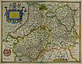
Hand-drawn map of Radnorshire, Brecknockshire, Ceredigion and Carmarthenshire by Christopher Saxton in 1578
-
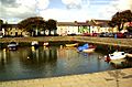
Aberaeron Harbour
-
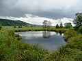
Cors Caron, a bog near Tregaron
-

A hill farm at Cwm Brefi
-
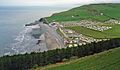
Caravan park at Clarach Bay
-
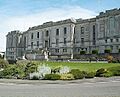
The National Library of Wales
-
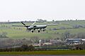
An unmanned aerial vehicle (UAV) at West Wales Airport


See also
 In Spanish: Ceredigion para niños
