Columbia County, Wisconsin facts for kids
Quick facts for kids
Columbia County
|
|
|---|---|

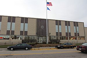
Columbia County courthouse in December 2014
|
|

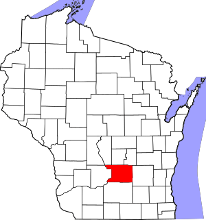
Location within the U.S. state of Wisconsin
|
|
 Wisconsin's location within the U.S. |
|
| Country | |
| State | |
| Founded | 1846 |
| Named for | Christopher Columbus |
| Seat | Portage |
| Largest city | Portage |
| Area | |
| • Total | 796 sq mi (2,060 km2) |
| • Land | 766 sq mi (1,980 km2) |
| • Water | 30 sq mi (80 km2) 3.8% |
| Population
(2020)
|
|
| • Total | 58,490 |
| • Estimate
(2023)
|
58,091 |
| • Density | 76.4/sq mi (29.5/km2) |
| Time zone | UTC−6 (Central) |
| • Summer (DST) | UTC−5 (CDT) |
| Congressional district | 6th |
Columbia County is a county located in the state of Wisconsin. It was named after Christopher Columbus. As of the 2020 census, about 58,490 people lived here. The main city and county seat is Portage. The county was created in 1846.
Columbia County is part of the larger Madison area. This means it's connected to the economy and community of Madison.
Contents
Geography
Columbia County covers a total area of about 796 square miles. Most of this area, 766 square miles, is land. The rest, about 30 square miles, is water. This makes up about 3.8% of the county's total area.
The highest point in the county is in the Baraboo Range. It is near Durward's Glen and is 1,480 feet above sea level.
Main Roads
Many important roads pass through Columbia County. These roads help people travel and transport goods.
 Interstate 39
 Interstate 90
 Interstate 94
 U.S. Highway 51
 U.S. Highway 151
 Highway 13
 Highway 16
 Highway 22
 Highway 23
 Highway 33
 Highway 44
 Highway 60
 Highway 73
 Highway 78
 Highway 89
 Highway 113
 Highway 127
 Highway 146
 Highway 188
Railroads
Trains also play a role in transportation. Several railroad companies operate here.
- Amtrak
- Wisconsin and Southern Railroad
- Canadian Pacific
- Union Pacific
- Columbus station
- Portage station
- Wisconsin Dells station
Airports
Two airports serve Columbia County. They help people travel by air.
- 94C - Gilbert Field airport
- C47 - Portage Municipal Airport
Neighboring Counties
Columbia County shares borders with several other counties.
- Marquette County – to the north
- Green Lake County – to the northeast
- Dodge County – to the east
- Dane County – to the south
- Sauk County – to the west
- Juneau County – to the northwest
- Adams County – to the northwest
People Living Here (Demographics)
| Historical population | |||
|---|---|---|---|
| Census | Pop. | %± | |
| 1850 | 9,565 | — | |
| 1860 | 24,441 | 155.5% | |
| 1870 | 28,802 | 17.8% | |
| 1880 | 28,065 | −2.6% | |
| 1890 | 28,350 | 1.0% | |
| 1900 | 31,121 | 9.8% | |
| 1910 | 31,129 | 0.0% | |
| 1920 | 30,468 | −2.1% | |
| 1930 | 30,503 | 0.1% | |
| 1940 | 32,517 | 6.6% | |
| 1950 | 34,023 | 4.6% | |
| 1960 | 36,708 | 7.9% | |
| 1970 | 40,150 | 9.4% | |
| 1980 | 43,222 | 7.7% | |
| 1990 | 45,088 | 4.3% | |
| 2000 | 52,468 | 16.4% | |
| 2010 | 56,833 | 8.3% | |
| 2020 | 58,490 | 2.9% | |
| U.S. Decennial Census 1790–1960 1900–1990 1990–2000 2010–2020 |
|||
2020 Census Information
In 2020, the county had 58,490 people. This means there were about 76 people for every square mile. Most people living in the county were White. There were also smaller groups of Black, Asian, and Native American people. About 3.7% of the population was of Hispanic or Latino background.
Communities
Columbia County has different types of communities. These include cities, villages, and towns.
Cities
Cities are larger communities with their own governments.
- Columbus (partly in Dodge County)
- Lodi
- Portage (This is the county seat, where the main government offices are)
- Wisconsin Dells (partly in Adams County, Juneau County, and Sauk County)
Villages
Villages are smaller than cities but still have their own local governments.
- Arlington
- Cambria
- Doylestown
- Fall River
- Friesland
- Pardeeville
- Poynette
- Randolph (mostly in Dodge County)
- Rio
- Wyocena
Towns
Towns are usually larger areas that include rural land and sometimes smaller communities.
Census-designated places
These are areas that are like towns but are not officially incorporated as cities or villages.
- Lake Wisconsin (partial)
Unincorporated communities
These are small communities that do not have their own local government.
Ghost town/neighborhood
See also
 In Spanish: Condado de Columbia (Wisconsin) para niños
 | Anna J. Cooper |
 | Mary McLeod Bethune |
 | Lillie Mae Bradford |

