
Communipaw facts for kids
Quick facts for kids
Communipaw, Jersey City
|
|
|---|---|

Communipaw, Jersey City
Location in Hudson County, New Jersey
|
|
| Country | United States |
| State | |
| County | Hudson |
| City | Jersey City |
| Elevation | 20 ft (6 m) |
| GNIS feature ID | 875597 |
Communipaw is a historic neighborhood in Jersey City, New Jersey. It is located near Liberty State Park and Bergen Hill. This area was one of the very first places where Europeans settled in North America.
The name Communipaw is also used for a famous avenue. This road starts near the Liberty State Park Station. It then goes through other neighborhoods like Bergen-Lafayette and the West Side. After that, it becomes part of the Lincoln Highway.
A busy spot called Communipaw Junction, or "The Junction," is where several streets meet. These include Communipaw Avenue, Summit Avenue, Garfield Avenue, and Grand Street. In the past, this was where people paid a fee to use the Bergen Point Plank Road.
Near Upper New York Bay, there's a special place called Communipaw Cove. It's part of a large state nature preserve. This cove is one of the last remaining tidal salt marshes in the Hudson River estuary. It's a great spot for nature lovers!
Contents
Exploring Communipaw's Past
Communipaw was once part of Bergen City, New Jersey from 1855 to 1870. Later, it joined Jersey City. The area grew into a city during the late 1800s. Some streets in the neighborhood are now part of the Communipaw-Lafayette Historic District. This district helps protect the old buildings and history.
Lafayette Park is a city square, much like Van Vorst Park or Hamilton Park. It was probably named after the Marquis de Lafayette. He was a French general who helped America during the Revolutionary War. He visited this area in 1799 and again in 1824. The buildings around the park were built at different times.
The Whitlock Cordage complex is a group of old factory buildings. They are located in the Lafayette section, near where the Morris Canal used to be. A group called the Housing Trust of America bought these buildings. They plan to turn them into affordable homes.
The area near Johnston Avenue has a special history. It was a stop on the Underground Railroad. This was a secret network that helped enslaved African-Americans find freedom. It was also an African-American burial ground. Ficken's Warehouse is another historic building here. It was once the main post office for Bergen City. Today, it is listed on the National Register of Historic Places listings in Hudson County, New Jersey.
Berry Lane Park is a newer park in the area. It was built on land that used to be an industrial site.
Early History of Communipaw


The Lenape People
Before Europeans arrived in the 1600s, Communipaw was a summer home for the Hackensack Indians. They were a group of the Lenape people. The Lenape were Native Americans who lived in this region. Other groups like the Raritan and Tappan also lived nearby. European settlers often called these groups "River Indians."
The name "Communipaw" likely comes from the Algonquian language of the Lenape. There are many old spellings, like Gamoenapa and Gemoenepaen. The name probably means "big landing-place from the other side of the river." It could also mean "other side of the water" or "landing place at the side of a river."
Dutch Settlement
In 1609, Henry Hudson explored this area for the Dutch East India Company. He anchored his ship near Communipaw. His mate, Robert Juet, wrote in the ship's log that it was "a very good land to fall in with, and a pleasant land to see."
In 1634, one of the first farms, called a bouwerie, was built in Communipaw. This was part of Pavonia, a large land grant owned by a Dutch businessman named Michiel Reyniersz Pauw. Some people thought "Communipaw" came from "Community of Pauw," but that's probably just a coincidence.
For a while, the area was called Jan de Lacher's Hoeck. This means "Jan the Laugher's Point." It was named after a Dutch settler, Jan Everts Bout, who was known for being loud and cheerful. Large farms, worked by enslaved Africans, spread across the flat lands near the water.
In 1643, some Tappan and Wecquaesgeek people sought safety here. They were trying to escape attacks from other tribes. Sadly, they were attacked in an event known as the Pavonia Massacre. This event led to a conflict called Kieft's War.
Communipaw was first part of the colony controlled by the Dutch West India Company. In 1653, it became part of the larger Commonality of New Amsterdam. This included settlements in Manhattan, Staten Island, and Long Island. In 1658, Communipaw became its own village. It was under the control of Bergen, which is now Bergen Square. By 1669, regular ferry service to New Amsterdam began.
In 1674, the English took over New Netherland for the last time. Communipaw then became part of the Province of New Jersey. It was in Bergen County. Even so, the area kept its strong Dutch culture for many years.
Famous American writers were inspired by Communipaw. Washington Irving visited often. He even went with future US president Martin van Buren. Irving wrote about Communipaw in The Legend of Sleepy Hollow. He said it was a place where old Dutch traditions were still strong. James Fenimore Cooper and Herman Melville also mentioned Communipaw in their books. John Quidor, an American painter, created artworks inspired by the village. These include Embarkation from Communipaw and The Voyage from Communipaw to Hell Gate.
Suydam Street, which means "south dam," is named after an early Dutch family. One of their descendants, Rev. J. Howard Suydam, was a historian for the Holland Society of New York.
Railroads and Industry
Originally, the waters near Communipaw were full of oyster beds. People harvested these oysters well into the 1800s. As the area grew, it became more industrial. Ports were built, and then train tracks. The shoreline was expanded using landfill, especially by the Lehigh Valley Railroad and the Central Railroad of New Jersey.
The Central Railroad of New Jersey Terminal, also known as Communipaw Terminal, was a major train station right on the waterfront. The cove just south of the station is still sometimes called Communipaw Cove. The railroad also had a Communipaw Station further inland. This station was along the train tracks now used by the Hudson Bergen Light Rail. Johnston Avenue is named after an early president of the railroad company.
Getting Around Communipaw Today
Buses travel through The Junction, a busy intersection in Communipaw. New Jersey Transit routes 6 and 81 go south through Greenville to Curries Woods. The 81 bus continues to Bayonne. Sometimes, the 6 bus changes its route slightly around the Lafayette Loop.
Northbound, the 6 bus goes to Journal Square. The 81 bus travels through Downtown Jersey City to Exchange Place. The closest stations for the Hudson Bergen Light Rail are nearby. These are the Garfield Avenue station in the Claremont neighborhood and the Liberty State Park station.
Images for kids
-
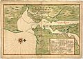
Map from around 1639 showing settlements near Manhattan.
-
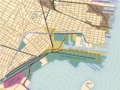
This 1910 map shows the village of Communipaw by the cove, surrounded by train tracks.
