
Franklin County, Illinois facts for kids
Quick facts for kids
Franklin County
|
||
|---|---|---|

Franklin County Courthouse in Benton
|
||
|
||

Location within the U.S. state of Illinois
|
||
 Illinois's location within the U.S. |
||
| Country | ||
| State | ||
| Founded | January 2, 1818 | |
| Named for | Benjamin Franklin | |
| Seat | Benton | |
| Largest city | West Frankfort | |
| Area | ||
| • Total | 432 sq mi (1,120 km2) | |
| • Land | 409 sq mi (1,060 km2) | |
| • Water | 23 sq mi (60 km2) 5.2% | |
| Population
(2020)
|
||
| • Total | 37,804 | |
| • Estimate
(2023)
|
37,138 |
|
| • Density | 87.51/sq mi (33.79/km2) | |
| Time zone | UTC−6 (Central) | |
| • Summer (DST) | UTC−5 (CDT) | |
| Congressional district | 12th | |

Franklin County is a county located in Southern Illinois. In 2020, about 37,804 people lived here. The biggest city in the county is West Frankfort. The main government center, called the county seat, is in Benton. This part of Southern Illinois is often called "Little Egypt" by local people.
Contents
History of Franklin County
Franklin County was created on January 2, 1818. It was formed from parts of two other counties: Gallatin and White counties. The county was named after Benjamin Franklin, a famous American inventor and statesman.
-
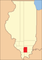
Franklin County looked like this when it was first formed in 1818.
-
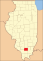
When Williamson County was created in 1839, Franklin County became its current size.


Coal Mining in Franklin County
People started mining coal in Franklin County as early as 1889. The King Coal Mine was one of the first places where coal was dug up.
Over the years, there were some serious accidents in the coal mines. This was because the coal deposits in Franklin County had high levels of gas. Between 1905 and 1968, there were eleven major mine accidents. For example, in 1905, an explosion at the Zeigler No. 1 mine killed about fifty people. In 1951, the worst explosion happened at the Orient No. 2 Mine, where 119 people lost their lives.
In 2004, a report showed that the area around West Frankfort in Franklin County had 17 coal mines.
Geography of Franklin County
Franklin County covers a total area of about 431 square miles. Most of this area, about 409 square miles, is land. The remaining 23 square miles, or 5.2%, is water. The Wayne Fitzgerrell State Recreation Area is a natural park located in this county.
Climate and Weather in Franklin County
| Weather chart for Benton, Illinois | |||||||||||||||||||||||||||||||||||||||||||||||
|---|---|---|---|---|---|---|---|---|---|---|---|---|---|---|---|---|---|---|---|---|---|---|---|---|---|---|---|---|---|---|---|---|---|---|---|---|---|---|---|---|---|---|---|---|---|---|---|
| J | F | M | A | M | J | J | A | S | O | N | D | ||||||||||||||||||||||||||||||||||||
|
2.9
39
21
|
2.9
45
26
|
4.2
56
36
|
4.5
67
45
|
4.6
76
54
|
4.1
85
63
|
3.2
90
68
|
3
88
65
|
2.9
81
58
|
2.9
69
45
|
4.5
56
37
|
3.6
43
26
|
||||||||||||||||||||||||||||||||||||
| temperatures in °F precipitation totals in inches source: The Weather Channel |
|||||||||||||||||||||||||||||||||||||||||||||||
|
Metric conversion
|
|||||||||||||||||||||||||||||||||||||||||||||||
In Benton, the county seat, temperatures usually range from 21°F in January to 90°F in July. The coldest temperature ever recorded was -22°F in January 1977. The hottest was 104°F in August 2007. The county gets about 2.87 inches of rain in February and up to 4.59 inches in May.
Franklin County has also experienced powerful storms. On April 21, 1912, a tornado destroyed buildings at the Possum Ridge Mine.
On March 18, 1925, the famous Tri-State Tornado hit Franklin County. This storm was one of the deadliest in U.S. history. It swept across the southern part of the county, causing huge damage in West Frankfort. Many of the town's mining buildings were badly hit. The small village of Parrish was also struck and was never rebuilt. The tornado caused 192 deaths in Franklin County, injured many more, and left many people without homes.
Counties Next to Franklin County
- Jefferson County (north)
- Hamilton County (east)
- Saline County (southeast)
- Williamson County (south)
- Jackson County (southwest)
- Perry County (west)
Transportation in Franklin County
- South Central Transit
Main Roads in Franklin County
 Interstate 57
 Illinois Route 14
 Illinois Route 34
 Illinois Route 37
 Illinois Route 148
 Illinois Route 149
 Illinois Route 154
 Illinois Route 184
People of Franklin County (Demographics)
| Historical population | |||
|---|---|---|---|
| Census | Pop. | %± | |
| 1820 | 1,763 | — | |
| 1830 | 4,083 | 131.6% | |
| 1840 | 3,682 | −9.8% | |
| 1850 | 5,681 | 54.3% | |
| 1860 | 9,393 | 65.3% | |
| 1870 | 12,652 | 34.7% | |
| 1880 | 16,129 | 27.5% | |
| 1890 | 17,138 | 6.3% | |
| 1900 | 19,675 | 14.8% | |
| 1910 | 25,943 | 31.9% | |
| 1920 | 57,293 | 120.8% | |
| 1930 | 59,442 | 3.8% | |
| 1940 | 53,137 | −10.6% | |
| 1950 | 48,685 | −8.4% | |
| 1960 | 39,281 | −19.3% | |
| 1970 | 38,329 | −2.4% | |
| 1980 | 43,201 | 12.7% | |
| 1990 | 40,319 | −6.7% | |
| 2000 | 39,018 | −3.2% | |
| 2010 | 39,561 | 1.4% | |
| 2020 | 37,804 | −4.4% | |
| 2023 (est.) | 37,138 | −6.1% | |
| U.S. Decennial Census 1790-1960 1900-1990 1990-2000 2010-2013 |
|||

In 2010, there were 39,561 people living in Franklin County. There were about 16,617 households, which are groups of people living together. The population density was about 96.8 people per square mile.
Most people in the county, about 97.7%, were white. Small percentages were Asian, American Indian, or Black. About 1.2% of the population was of Hispanic or Latino background. Many residents have German (21.8%), Irish (18.7%), or English (15.9%) ancestry.
The average age of people in the county was 41.8 years old. About 30% of households had children under 18 living with them. The average income for a household was $34,381. About 19.8% of the population lived below the poverty line.
Communities in Franklin County
Cities
- Benton (county seat)
- Christopher
- Orient
- Sesser
- West Frankfort
- Zeigler
Villages
- Buckner
- Ewing
- Freeman Spur (mostly in Williamson County)
- Hanaford
- Macedonia (partly in Hamilton County)
- North City
- Royalton
- Thompsonville
- Valier
- West City

Census-designated place
Townships
Franklin County is divided into twelve smaller areas called townships:
- Barren
- Benton
- Browning
- Cave
- Denning
- Eastern
- Ewing
- Frankfort
- Goode
- Northern
- Six Mile
- Tyrone
Unincorporated Communities
- Akin
- Akin Junction
- Cleburne
- Deering City
- Frisco
- Kegley
- Meyer
- Parrish
- Pershing
- Plumfield
- Rend City
- Steel City
- Valier Patch
- West End
- Whittington
Education in Franklin County
Regional Education Office
- Franklin, Johnson, Massac, and Williamson County Regional Office of Education #21
Schools for Kids (Primary and Secondary)
- Christopher Unit School District 99
- Sesser-Valier Community Unit School District 196
- Benton Community Consolidated School District 47
- Frankfort Community Unit School District 168
- Zeigler-Royalton Community Unit School District 188
- Thompsonville Community Unit School District 174
- Ewing-Northern Community Consolidated School District 115
Colleges and Higher Education
- John A. Logan College Extension Center - West Frankfort
Special Education Services
- Franklin & Jefferson County Special Education Cooperative
See also
 In Spanish: Condado de Franklin (Illinois) para niños
