
Geography of New Caledonia facts for kids

Map of New Caledonia
|
|
 |
|
| Geography | |
|---|---|
| Location | Pacific Ocean |
| Coordinates | 21°21′03″S 165°25′56″E / 21.350781°S 165.432129°E |
| Area | 18,575 km2 (7,172 sq mi) |
| Area rank | 53rd |
| Length | 350 km (217 mi) |
| Width | 70 km (43 mi) |
| Highest elevation | 1,628 m (5,341 ft) |
| Highest point | Mont Panié |
| Administration | |
|
France
|
|
| Overseas departments and territories of France | New Caledonia |
| Largest settlement | Nouméa (pop. 91,386) |
| Demographics | |
| Population | 208,709 (2004) |
| Pop. density | 12.75 /km2 (33.02 /sq mi) |
| Ethnic groups | Melanesian 44.6%, European 34.5%, Wallisian 9.1%, Tahitian 2.7%, Indonesian 2.6%, Vietnamese 1.4%, Ni-Vanuatu 1.2%, other (Filipino) 3.9% |
New Caledonia, also known as Nouvelle-Calédonie, is a special group of islands that belongs to France. It's located in the Melanesia region of the southwest Pacific Ocean. This island chain is very special because it has helped to protect unique plants and animals that have been around since the time of the dinosaurs.
Long ago, New Caledonia was a stop for the Lapita people, who were ancestors of the Polynesians. During World War II, it was also an important naval base for the Allied Forces.
The islands are found east of Australia and north of New Zealand. They are just south of the Equator and west of Fiji and Vanuatu. New Caledonia includes a main island called Grande Terre, the Loyalty Islands, and many smaller islands. The total land area is about 18,575.5 square kilometers (7,172 square miles). The coastline stretches for 2,254 kilometers (1,401 miles).
New Caledonia is part of a mostly underwater continent called Zealandia. This continent broke away from Antarctica millions of years ago. Then, it separated from Australia. New Caledonia itself drifted away from Australia about 66 million years ago. It moved to its current spot about 50 million years ago. Because it has been stable and isolated for so long, New Caledonia is like a "biological ark." It protects unique plants and animals that are not found anywhere else.
Contents
What Makes Up New Caledonia?

New Caledonia is made up of several parts. The main island is Grande Terre. There are also smaller islands like the Belep archipelago to the north. To the east are the Loyalty Islands. South of Grande Terre is the Isle of Pines. Further west are the Chesterfield Islands and Bellona Reefs. Each of these island groups formed in a different way.
- The New Caledonia archipelago, including Grande Terre, Belep, and the Île des Pins, formed from folds in the Earth's deep mantle. This happened between 251 and 1.5 million years ago. This process created rocks rich in nickel.
- The Loyalty Islands, about 100 kilometers (62 miles) to the east, are coral and limestone islands. They grew on top of old volcanoes that collapsed.
- The Chesterfield Islands, 550 kilometers (342 miles) to the northwest, are reefs that stick out from the ocean floor.
- The Matthew and Hunter Islands, about 450 and 520 kilometers (280 and 323 miles) to the east, are volcanic islands. They are at the southern end of the New Hebrides island chain.
Grande Terre is the largest island and the only one with mountains. It covers 16,372 square kilometers (6,321 square miles). It is long and narrow, about 350 kilometers (217 miles) long and 50 to 70 kilometers (31 to 43 miles) wide. A mountain range runs along the island. Five peaks are over 1,500 meters (4,921 feet) high. The highest point is Mont Panié, which is 1,628 meters (5,341 feet) tall.
France and Vanuatu both claim the uninhabited Matthew and Hunter Islands.
The Story of Zealandia

The New Caledonian islands are like small pieces of a continent. They came from Zealandia, a mostly underwater continent. Zealandia was once part of the huge southern supercontinent called Gondwana, which existed during the time of the dinosaurs.
Grande Terre, with its highest point Mont Panié, is the tallest part of the Norfolk Ridge. This ridge is a long, mostly underwater arm of the Zealandia continent. Zealandia and Australia broke away from Antarctica between 85 and 130 million years ago. Then, Australia and Zealandia split apart 60–85 million years ago.
Most of Zealandia, about 93%, is hidden beneath the Pacific Ocean. New Zealand is the largest part of Zealandia that is above sea level. New Caledonia is the next largest part.
Because New Caledonia came from a continent, it's different from many other Pacific islands like the Hawaiian Islands. Those islands were formed by recent volcanoes. New Caledonia's separation from Australia and New Zealand led to a long time of evolution in almost complete isolation. This means New Caledonia has many unique species of plants and animals. Their ancestors were on the island when it broke away from Gondwana millions of years ago. Some entire groups of plants and animals are found only here.
Some scientists think New Caledonia might have been completely underwater at different times. However, plant experts believe some areas must have stayed above sea level. These areas would have been safe places for the original plants to survive. New Caledonia was not completely cut off, though. New species arrived, and some Gondwanan species spread further into the Pacific.
Climate and Weather

New Caledonia has a tropical climate. This means it's hot and humid. The weather is affected by southeasterly trade winds.
Cyclones are a natural danger here. They happen most often between November and March. The amount of rain changes across the island. The north gets more rain, while the south gets less. The capital city, Nouméa, usually has a dry season from August to mid-December. The rain then starts suddenly in January. The northeastern coast gets the most rain, with about 2,400 millimeters (94 inches) recorded near sea level in Pouébo.
Land and Rivers
The land on Grande Terre has plains along the coast and mountains in the middle. The lowest point is the Pacific Ocean at 0 meters. The highest point is Mont Panie, at 1,628 meters (5,341 feet) high.
The Diahot River is the longest river in New Caledonia. It flows for about 100 kilometers (60 miles). It empties into the Baie d'Harcourt in the northwest.
In 1993, about 12% of New Caledonia's land was used for grazing animals. Forests and woodlands covered 39%. A problem for the environment is erosion. This is caused by mining and forest fires.
Unique Plants and Animals

.jpg)


Because it has been isolated for so long, New Caledonia is like a "biological Noah's Ark." It is home to many unique living plants and animals, and also special fossils.
One unique bird is the crested and almost flightless kagu (called cagou in French). Its closest relative might be the sunbittern from South America. A very special plant is Amborella trichopoda. This is the only known member of the most basic group of flowering plants. These unique species make the island a treasure for biologists and people who work to protect nature.
The island used to have horned fossil turtles and land crocodiles. These animals died out soon after humans arrived. There are no native amphibians, but geckos fill many of their roles. The crested gecko (Correlophus ciliatus), which was thought to be extinct, was found again in 1994. Leach's giant gecko (Rhacodactylus leachianus) is the world's largest gecko at 14 inches. It hunts smaller lizards. The only native mammals are four types of bats, including the New Caledonia flying fox.
New Caledonia has 13 of the 19 types of evergreen trees in the Araucaria group. The island has been called a "Jurassic Park" because its plants look very old and many are found nowhere else. Besides Amborella, the island has more gymnosperm species than any other tropical land. 43 of its 44 conifer species are unique to the island. It also has the world's only known parasitic conifer, Parasitaxus usta.
Because of their ancient look, the dry forests of western New Caledonia were used to film the first episode of the BBC series Walking with Dinosaurs.
Rich in Minerals
New Caledonia has the world's largest known area of special rock called ultrabasic rock. This rock comes from deep inside the Earth's mantle. These rocks are full of valuable minerals like nickel, chromium, iron, cobalt, manganese, silver, gold, lead, and copper. The soil in these areas is toxic because of the minerals. This has helped protect the unique plants that have adapted to it. Other plants cannot grow there, so they don't compete with the native species.
People and History

Before Europeans Arrived
New Caledonia is considered the southernmost group of islands in Melanesia. This links it to nearby islands to its north, rather than New Zealand to the south. The languages spoken by the native people, called Kanaks, are related to languages in Vanuatu. These languages are part of the larger Austronesian language family. Languages like Fijian, Māori, and other Polynesian languages are cousins of the New Caledonian languages.
Scientists believe the Lapita culture, known for its pottery, started around 1500 BC. The first known human settlement in New Caledonia was around 1240 BC. These early settlers were the Lapita people. They later moved on to Fiji, where the Polynesian expansion began.
After Europeans Arrived
Europeans started exploring the area in the 18th century. The British explorer James Cook saw Grande Terre in 1774. He named it New Caledonia, because Caledonia is the Latin name for Scotland. In 1853, under Napoléon III, the area became a French colony. The French brought people from other places, like Arabs from North Africa, to settle there.
Because of its important location and because Japanese troops did not occupy it, New Caledonia was a vital naval base for the Allied Forces during World War II.
Today, French is the official language. However, 28 native languages are still spoken. In 2004, almost everyone (97%) could speak French. About 37.1% could speak one of the native Austronesian languages.
In 1996, the native Melanesian Kanak community made up 44.6% of the population. They are no longer the majority due to people moving to the islands from other places. The rest of the population includes:
- Europeans (34.5%), mostly French, but also German, British, and Italian.
- Polynesians (11.8%), including people from Wallis and Futuna and Tahiti.
- Indonesians (2.6%).
- Vietnamese (1.4%).
- Ni-Vanuatu (1.2%).
- Other groups (3.9%), like Tamils, other South Asians, Berbers, Japanese, Chinese, Fijians, Arabs, and people from other French territories.
Images for kids
-
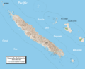
Detailed map of New Caledonia showing physical relief and the territory's towns and villages

See also
 In Spanish: Geografía de Nueva Caledonia para niños
