Harrison County, Texas facts for kids
Quick facts for kids
Harrison County
|
|
|---|---|

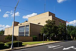
Harrison County Courthouse in Marshall
|
|

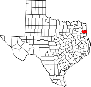
Location within the U.S. state of Texas
|
|
 Texas's location within the U.S. |
|
| Country | |
| State | |
| Founded | 1842 |
| Named for | Jonas Harrison |
| Seat | Marshall |
| Largest city | Marshall |
| Area | |
| • Total | 916 sq mi (2,370 km2) |
| • Land | 900 sq mi (2,000 km2) |
| • Water | 16 sq mi (40 km2) 1.7%% |
| Population
(2020)
|
|
| • Total | 68,839 |
| • Density | 75/sq mi (29/km2) |
| Time zone | UTC−6 (Central) |
| • Summer (DST) | UTC−5 (CDT) |
| Congressional district | 1st |
Harrison County is a county located on the eastern border of Texas. In 2020, about 68,839 people lived here. The main city and county seat is Marshall. The county was created in 1839 and officially started in 1842. It is named after Jonas Harrison, who was a lawyer and a leader in the Texas Revolution.
Before the Civil War, Harrison County was known for its large cotton farms. Many enslaved African Americans were forced to work on these farms. They made up a big part of the population. After the Civil War, African Americans continued to be a majority in the county for many years. However, they faced many challenges, including laws that made it hard for them to vote.
Later, many African Americans moved away from the South to find new jobs and escape unfair laws. Since the late 1900s, more white residents have moved into the county. Harrison County is part of the Marshall micropolitan area. This means it's a smaller city area that is also connected to the larger Longview-Marshall region. It is also part of the Ark-La-Tex area, where Arkansas, Louisiana, and Texas meet.
Contents
History of Harrison County
Early Settlement and Growth
People from the United States began settling in what is now Harrison County in the 1830s. In 1835, the Mexican government gave land grants to these settlers. After the Texas Revolution, Harrison County was formed in 1839 from Shelby County. It was named after Jonas Harrison, a key figure in the revolution. The county officially began operating in 1842.
In 1846, parts of Harrison County were used to create Panola and Upshur counties. The city of Marshall was founded in 1841. It became the county seat in 1842.
The area attracted many farmers from the Southern United States. They started large cotton farms and brought enslaved African Americans to work on them. East Texas, including Harrison County, had many cotton farms and a large enslaved population. By 1850, Harrison County had more enslaved people than any other county in Texas. In 1860, about 59% of the county's population, or 8,746 people, were enslaved.
In 1861, the county's voters, who were mostly white men, strongly supported leaving the United States.
Changes After the Civil War
After the Civil War ended, Harrison County was part of the area controlled by federal troops during a time called Reconstruction. Some white residents were unhappy with the changes, especially giving voting rights to formerly enslaved people. For a while, the county government included both white and Black officials.
By 1880, a group called the Citizen's Party gained control of the county government. They kept control for many years. This was partly because new state laws made it very difficult for African Americans to vote. White residents also used violence to maintain control. Harrison County had a high number of violent acts against African Americans during this time.
In the 1870s, the county's economy grew beyond farming. The Texas and Pacific Railway set up its main offices and repair shops in Marshall. This brought new jobs and helped transport cotton and other goods.
Even with new industries, Harrison County remained mostly a farming area until the 1930s. From 1880 to 1930, African Americans made up about 60% of the population. Many worked as tenant farmers, meaning they rented land to farm.
In 1901, new laws in Texas made it harder for African Americans to vote. These laws included poll taxes, which required people to pay to vote. These restrictions lasted until the 1960s, when new national laws protected voting rights.
Oil was discovered in the county in 1928, which helped the economy. However, the Great Depression in the 1930s greatly affected farming. World War II helped end the depression. From 1940 to 1970, many African Americans moved from the South to the West Coast. They sought new jobs in defense factories and to escape unfair laws.
The county's population decreased until 1980, when it started to grow again. More white residents have moved in, making them the majority. In recent years, many conservative white voters in Texas have joined the Republican Party.
Geography and Nature
Harrison County covers about 916 square miles. About 900 square miles are land, and 16 square miles (1.7%) are water. The northern and eastern parts of the county drain into the Red River in Louisiana. This happens through creeks like Little Cypress Creek, Cypress Bayou, and Caddo Lake. The southern part of the county drains into the Sabine River, which forms part of its southern border. These rivers and lakes were very important for travel in the past.
Neighboring Counties
- Marion County (north)
- Caddo Parish, Louisiana (east)
- Panola County (south)
- Rusk County (southwest)
- Gregg County (west)
- Upshur County (northwest)
Main Roads
 I-20
I-20


 Future I-369 / US 59
 US 80
US 80 SH 43
SH 43 SH 49
SH 49 SH 154
Protected Natural Areas
- Caddo Lake National Wildlife Refuge
Towns and Communities
Cities
- Hallsville
- Longview (mostly in Gregg County)
- Marshall (county seat and largest city)
- Scottsville
- Uncertain
- Waskom
Unincorporated Communities
Population and People
| Historical population | |||
|---|---|---|---|
| Census | Pop. | %± | |
| 1850 | 11,822 | — | |
| 1860 | 15,001 | 26.9% | |
| 1870 | 13,241 | −11.7% | |
| 1880 | 25,177 | 90.1% | |
| 1890 | 26,721 | 6.1% | |
| 1900 | 31,878 | 19.3% | |
| 1910 | 37,243 | 16.8% | |
| 1920 | 43,565 | 17.0% | |
| 1930 | 48,937 | 12.3% | |
| 1940 | 50,900 | 4.0% | |
| 1950 | 47,745 | −6.2% | |
| 1960 | 45,594 | −4.5% | |
| 1970 | 44,841 | −1.7% | |
| 1980 | 52,265 | 16.6% | |
| 1990 | 57,483 | 10.0% | |
| 2000 | 62,110 | 8.0% | |
| 2010 | 65,631 | 5.7% | |
| 2020 | 68,839 | 4.9% | |
| 2024 (est.) | 71,370 | 8.7% | |
| U.S. Decennial Census 1850–2010 2010–2020 |
|||
| Race / Ethnicity (NH = Non-Hispanic) | Pop 2000 | Pop 2010 | Pop 2020 | % 2000 | % 2010 | % 2020 |
|---|---|---|---|---|---|---|
| White alone (NH) | 43,044 | 42,654 | 42,039 | 69.30% | 64.99% | 61.07% |
| Black or African American alone (NH) | 14,861 | 14,303 | 13,448 | 23.93% | 21.79% | 19.54% |
| Native American or Alaska Native alone (NH) | 165 | 277 | 294 | 0.27% | 0.42% | 0.43% |
| Asian alone (NH) | 186 | 331 | 483 | 0.30% | 0.50% | 0.70% |
| Pacific Islander alone (NH) | 21 | 26 | 28 | 0.03% | 0.04% | 0.04% |
| Other race alone (NH) | 28 | 52 | 267 | 0.05% | 0.08% | 0.39% |
| Mixed race or Multiracial (NH) | 489 | 734 | 2,441 | 0.79% | 1.12% | 3.55% |
| Hispanic or Latino (any race) | 3,316 | 7,254 | 9,839 | 5.34% | 11.05% | 14.29% |
| Total | 62,110 | 65,631 | 68,839 | 100.00% | 100.00% | 100.00% |
In 2000, the county had 62,110 people. There were 23,087 households and 16,945 families. The population density was about 69 people per square mile. By 2020, the population grew to 68,839.
In 2020, the population was made up of different groups. About 61.07% were non-Hispanic white. About 19.54% were Black or African American. About 14.29% were Hispanic or Latino of any race. Other groups included Native American, Asian, Pacific Islander, and people of two or more races. This shows the county's population is becoming more diverse.
In 2018, the average household income was $51,202. About 14.7% of the people lived below the poverty line.
Education in Harrison County
Several school districts serve the students of Harrison County:
- Elysian Fields ISD (also in Panola County)
- Hallsville ISD
- Harleton ISD
- Karnack ISD
- Marshall ISD
- New Diana ISD (mostly in Upshur County)
- Ore City ISD (mostly in Upshur County, some in Marion County)
- Waskom ISD
Most of Harrison County is part of the service area for Panola College. However, the Hallsville ISD area is served by Kilgore Junior College.
Politics
The county is represented in the Texas House of Representatives by Republican Chris Paddie. He used to be the mayor of Marshall.
| Year | Republican | Democratic | Third party | |||
|---|---|---|---|---|---|---|
| No. | % | No. | % | No. | % | |
| 2024 | 22,658 | 74.92% | 7,369 | 24.37% | 216 | 0.71% |
| 2020 | 21,466 | 72.23% | 7,908 | 26.61% | 343 | 1.15% |
| 2016 | 18,749 | 70.62% | 7,151 | 26.94% | 648 | 2.44% |
| 2012 | 17,512 | 66.92% | 8,456 | 32.31% | 202 | 0.77% |
| 2008 | 17,103 | 65.38% | 8,887 | 33.97% | 168 | 0.64% |
| 2004 | 16,473 | 62.82% | 9,642 | 36.77% | 108 | 0.41% |
| 2000 | 13,834 | 60.23% | 8,878 | 38.65% | 258 | 1.12% |
| 1996 | 9,835 | 45.42% | 10,307 | 47.60% | 1,513 | 6.99% |
| 1992 | 8,733 | 38.50% | 9,538 | 42.05% | 4,412 | 19.45% |
| 1988 | 11,957 | 56.18% | 8,974 | 42.16% | 354 | 1.66% |
| 1984 | 12,618 | 61.52% | 7,773 | 37.90% | 118 | 0.58% |
| 1980 | 9,328 | 53.32% | 7,746 | 44.28% | 419 | 2.40% |
| 1976 | 7,787 | 49.79% | 7,796 | 49.85% | 56 | 0.36% |
| 1972 | 9,600 | 68.28% | 4,333 | 30.82% | 127 | 0.90% |
| 1968 | 3,668 | 26.29% | 4,959 | 35.55% | 5,324 | 38.16% |
| 1964 | 5,568 | 46.67% | 6,351 | 53.24% | 11 | 0.09% |
| 1960 | 4,613 | 46.39% | 5,108 | 51.36% | 224 | 2.25% |
| 1956 | 5,048 | 64.76% | 2,668 | 34.23% | 79 | 1.01% |
| 1952 | 4,708 | 51.01% | 4,516 | 48.93% | 5 | 0.05% |
| 1948 | 946 | 16.93% | 2,504 | 44.81% | 2,138 | 38.26% |
| 1944 | 619 | 12.36% | 3,588 | 71.63% | 802 | 16.01% |
| 1940 | 681 | 13.11% | 4,515 | 86.89% | 0 | 0.00% |
| 1936 | 302 | 8.14% | 3,400 | 91.69% | 6 | 0.16% |
| 1932 | 528 | 11.47% | 4,057 | 88.12% | 19 | 0.41% |
| 1928 | 1,776 | 46.69% | 2,023 | 53.18% | 5 | 0.13% |
| 1924 | 463 | 14.19% | 2,573 | 78.88% | 226 | 6.93% |
| 1920 | 377 | 11.85% | 2,134 | 67.09% | 670 | 21.06% |
| 1916 | 172 | 10.64% | 1,374 | 85.02% | 70 | 4.33% |
| 1912 | 140 | 9.70% | 1,140 | 79.00% | 163 | 11.30% |
| Year | Republican | Democratic | Third party(ies) | |||
|---|---|---|---|---|---|---|
| No. | % | No. | % | No. | % | |
| 2024 | 22,137 | 73.60% | 7,408 | 24.63% | 534 | 1.78% |
More to Explore
- List of museums in East Texas
- National Register of Historic Places listings in Harrison County, Texas
- Recorded Texas Historic Landmarks in Harrison County
See also
 In Spanish: Condado de Harrison (Texas) para niños


