International Cospas-Sarsat Programme facts for kids
 |
|
| Established | 1 July 1988 (Date definitive agreement was signed; preceding memorandums of understanding signed 23 November 1979 and 5 October 1984) |
|---|---|
| Type | Intergovernmental organization |
| Legal status | Active |
| Headquarters | Montreal, Quebec, Canada |
|
Membership
|
45 Formally associated "Participant" states
and agencies Hong Kong, China, Marine Department** International Telecommunication Development Company (Taiwan)** *Party State, and Space- and Ground-Segment Provider **Ground-Segment Provider ***Space- and Ground-Segment Provider Additionally, although not State Participants, the European Union, through its Galileo Programme, is a Space- and Ground-Segment Provider, and EUMETSAT is a Space-Segment Provider |
|
Official languages
|
English French Russian |
|
Head
|
Shefali Juneja (Head of Secretariat) |
|
Council Chair (rotating)
|
Bruno Chazal (France) |
| Website | |
The International Cospas-Sarsat Programme is a global system that uses satellites to help with search and rescue (SAR) missions. It's a group of 45 countries and organizations working together. They don't make money, and their main goal is to help people in danger.
Their job is to find special emergency radio signals from people, planes, or boats that are in trouble. Then, they send this alert to rescue teams. About 65 satellites orbit Earth, carrying special equipment. These satellites pick up emergency signals from anywhere on the planet, especially from beacons sending signals on the 406 MHz frequency.
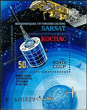
They find where the emergency is and send the alert to over 200 countries. This service is free for beacon owners and governments. Cospas-Sarsat was started in 1979 by Canada, France, the United States, and the former Soviet Union. The first rescue using this technology happened on September 10, 1982. The official agreement for the organization was signed by these four countries on July 1, 1988.
The name Cospas-Sarsat comes from two parts. COSPAS is a Russian acronym that means "Space System for the Search of Vessels in Distress." SARSAT is an acronym for "Search And Rescue Satellite-Aided Tracking."
Contents
What Cospas-Sarsat Does
Cospas-Sarsat is famous for finding emergency beacons from planes, ships, and people in remote areas. It then sends these alerts to search-and-rescue (SAR) teams. You can buy these special beacons (called 406-MHz beacons) from many companies. Cospas-Sarsat does not make or sell them.
Since September 1982, Cospas-Sarsat has helped rescue at least 63,745 people in 19,883 rescue events. In 2023, they helped rescue almost nine people every day. Here's a quick look at recent rescue numbers:
| Year | People Rescued | SAR Events → | Aviation | Land | Maritime |
|---|---|---|---|---|---|
| 2023 | 3,109 | 1,076 | 20% | 44% | 36% |
| 2022 | 3,223 | 1,144 | 20% | 39% | 41% |
| 2021 | 3,623 | 1,149 | 18% | 45% | 37% |
These numbers are actually lower than the real total. This is because they only count cases where rescue teams send a detailed report back to Cospas-Sarsat.
Cospas-Sarsat itself does not do the actual rescue operations. That job belongs to the rescue teams in different countries. Cospas-Sarsat simply provides the important alert information to these teams.
This organization works with groups like the United Nations, the International Civil Aviation Organization (ICAO), and the International Maritime Organization (IMO). This helps make sure their rescue services fit global needs and standards. For example, the IMO requires Cospas-Sarsat beacons on many large ships. ICAO also requires them on aircraft for international flights.
Cospas-Sarsat only listens for alerts from digital distress beacons that send signals on 406 MHz. Older beacons that used 121.5 MHz or 243 MHz are no longer monitored by satellites.
Cospas-Sarsat has received many awards for its humanitarian work. It was even added to the Space Foundation's Space Technology Hall of Fame. This honor is for space technologies that improve life for everyone.
How the System Works
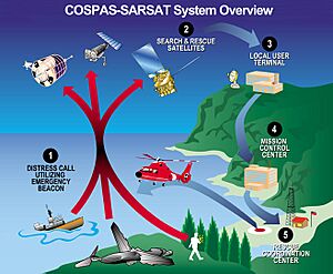
The Cospas-Sarsat system has two main parts: equipment in space and equipment on the ground.
- Distress radio-beacons: These are special devices activated in an emergency.
- Satellites: These carry special equipment (SARR and SARP) to pick up and relay distress signals.
- Ground Stations (LUTs): These are ground stations that receive signals from the satellites.
- Mission Control Centres (MCCs): These centers get alert data from the LUTs and send it to rescue teams.
- Rescue Coordination Centres (RCCs): These centers help organize the rescue response.
Emergency Beacons
A Cospas-Sarsat distress beacon is a digital radio transmitter that sends a signal on 406 MHz. It's used in life-threatening emergencies to call for help. Many companies make and sell these beacons.
There are three main types:
- ELT (Emergency Locator Transmitter): For use on aircraft.
- EPIRB (Emergency Position-Indicating Radio Beacon): For use on marine vessels.
- PLB (Personal Locator Beacon): Carried by individuals, often in remote areas.
Beacons don't transmit until an emergency happens or when a user tests them. Some beacons are activated by pressing a button. Others activate automatically, like ELTs in a crash or EPIRBs when they touch water. Cospas-Sarsat does not charge any fees for owning or using a beacon.
Satellites in Space
The Cospas-Sarsat system uses special equipment (SARR and SARP) on different types of satellites:
- Five satellites in low Earth orbit (LEOSAR).
- Twelve satellites in geostationary orbit (GEOSAR).
- 48 satellites in medium Earth orbit (MEOSAR).
A SARR or SARP is like an extra piece of equipment added to satellites. These satellites are mainly in space for other reasons, like weather forecasting or navigation. A SARR sends the distress signal to a ground station right away. A SARP records the signal data and sends it later when the satellite passes over a ground station.
Ground Stations
Ground stations, called LUTs (local user terminals), monitor the satellites. They have special antennas to track the satellites. Countries or agencies set up these LUTs. The distress messages received by a LUT go to a mission control center (MCC). The MCC then uses computers to send the alert data, especially the beacon's location, to rescue centers around the world.
How Distress Signals are Processed
When a distress beacon is activated, the Cospas-Sarsat system does two things:
- It reads the digital message from the beacon. This message includes information like the identity of the plane or boat. Some beacons also send their exact location from a GPS receiver.
- It uses math to figure out the beacon's location, even if the beacon doesn't send its own location.
Cospas-Sarsat is the only satellite distress system that can find a beacon's location in two different ways. This makes it very reliable.
The special equipment (SARR and SARP) is usually on satellites that have another main job. LEOSAR and GEOSAR satellites are mostly for weather. MEOSAR satellites are mainly for navigation.
LEOSAR System
LEOSAR was the first type of satellite system Cospas-Sarsat used. These satellites orbit the Earth from pole to pole, covering the whole planet over time. Because they are in low orbit, they only see a small part of Earth at once. This means there might be a delay before a LEOSAR satellite passes over a distress signal.
To solve this, LEOSAR satellites have "store-and-forward" SARP modules. The satellite can pick up a distress message from a remote area. Then, it stores the data and sends it to a ground station later when it flies over one. The five LEOSAR satellites orbit Earth in about 100 minutes. They cover the North and South Poles more often.
The LEOSAR system uses something called the Doppler effect. This is how the frequency of a signal changes as the satellite moves closer or farther away from the beacon. By measuring this change, ground stations can calculate the beacon's exact location.
GEOSAR System
GEOSAR satellites stay in a fixed position above the Earth. Because they don't move relative to the ground, they can't use the Doppler effect to find a beacon's location. So, GEOSAR satellites can only relay a beacon's distress message. If the beacon has a GPS and sends its location, then that location is sent to rescue teams.
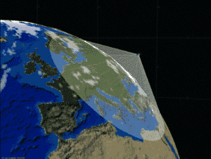
Even though GEOSAR satellites can't find the location on their own, they have an advantage. They cover almost the entire Earth in real time, except for the polar regions.
MEOSAR System
MEOSAR is the newest and most advanced part of the Cospas-Sarsat system. It combines the best features of LEOSAR and GEOSAR. MEOSAR satellites are in medium Earth orbit. They cover large areas and move enough to use the Doppler effect for location finding.
The MEOSAR system uses special equipment on navigation satellites like the European Union's Galileo, Russia's Glonass, and the United States' Global Positioning System (GPS). China also joined in November 2022, adding Cospas-Sarsat equipment to six of its BeiDou (BDS) satellites.
MEOSAR started sending alert data on December 13, 2016. After more testing, it was declared fully operational on April 25, 2023. The MEOSAR system helps find 406-MHz beacons almost instantly. For example, MEOSAR data helped find the crash site of EgyptAir flight 804 in the Mediterranean Sea.
The Galileo part of MEOSAR can even send a message back to the distress beacon. This can make a light or sound on the beacon to confirm that the distress message was received.
Ground Segment Details
As of December 2022, there are 55 LEOLUT antennas, 27 GEOLUT antennas, and 26 MEOLUT stations (each with multiple antennas). The data from these ground stations is sent to and shared by 32 MCCs (mission control centers) around the world. Fourteen of these MCCs can process data from all three types of satellite systems.
Beacon Technology Today
Most Cospas-Sarsat 406-MHz beacons also send distress signals on other frequencies. Many have a 121.5-MHz transmitter. This signal can be picked up by local search teams (in the air, on the ground, or at sea) using special equipment to find the direction.
Newer EPIRBs also include an automatic identification system (AIS) transmitter. This sends a signal in the marine VHF band. It allows nearby ships to easily track the beacon. Some new PLBs for life vests also send an AIS signal. This acts as a "man overboard" system, setting off alarms on nearby vessels and helping them track the person.
These combined signals allow for global alerts through the 406-MHz satellite transmission. They also allow for quick local response from the 121.5-MHz and AIS transmissions, especially by nearby ships.
After some recent plane accidents, ICAO asked for new ways to track planes in distress. Cospas-Sarsat created new rules for ELTs (Emergency Locator Transmitters) that track planes in trouble. These new ELTs (called ELT(DT)s) activate automatically when a plane enters dangerous flight situations. This means a plane in distress can be tracked during the flight, before any crash, without anyone on board needing to do anything. Cospas-Sarsat started using these new ELT(DT)s on January 1, 2023.
How Beacons Transmit Signals
For over 30 years, Cospas-Sarsat 406-MHz digital beacons used one main way to send signals, called BPSK. These signals are very short, about half a second long. They use a small amount of radio space (about 3 kHz).
Cospas-Sarsat recently added a new way for beacons to send signals, using "spread-spectrum" technology. These are called "second-generation" beacons. This new method saves battery power and helps the Cospas-Sarsat system find the beacon's location more accurately. It also makes it easier for many beacons to use the same radio space without interfering with each other. Second-generation beacons send signals for one second. They can also send more information over time by changing the message bits in each transmission. These new beacons started being used in ELT(DT)s in January 2024. Cospas-Sarsat expects to use this technology for other types of beacons later in 2024.
History of Cospas-Sarsat
Early Ideas and Tests
In the early 1970s, scientists in Canada wondered if an ELT signal could be found and located from space. They realized that the Doppler effect (how a signal's frequency changes as the satellite moves) could make this possible. They worked with an amateur radio satellite and successfully located a modified ELT. NASA in the United States heard about this success and agreed to work together.
First Agreement
On November 23, 1979, the U.S. National Aeronautics and Space Administration (NASA), the USSR Ministry of Merchant Marine, France's CNES, and Canada's Department of Communications signed an agreement. They agreed to work together on an experimental satellite-aided search and rescue project.
The goal was to show that equipment on low-orbiting satellites could help find distress signals. They would do this by relaying information from planes and ships in trouble to ground stations. These ground stations would then process the information and send it to rescue services.
System Development
The first satellite for the system, "COSPAS-1" (Kosmos 1383), was launched on June 29, 1982. Cospas-Sarsat began tracking distress beacons in September 1982. On September 9, 1982, while testing the satellite, COSPAS-1 found an ELT signal in British Columbia, Canada. It sent the information to a test ground station. Canadian teams quickly figured out the location of a small plane that was 90 km off course. Within hours, the crash survivors were rescued. This was the first time Cospas-Sarsat helped save lives. Authorities believed the pilot would have died without this quick satellite detection.
Before Cospas-Sarsat, planes used 121.5 MHz for distress signals, and military planes used 243.0 MHz. Finding these signals depended on other planes nearby picking them up. Then, ground equipment would find the direction of the signal. Satellites made it possible to find these signals globally.
Each of the four founding countries took on a major task. The United States designed and built the ground stations (LUTs) to receive signals from the satellites. France and Canada were in charge of processing the data and decoding it. They designed the computer that figured out the beacon's location using the Doppler effect. The former Soviet Union designed and built the first satellite. Engineers from all four countries met in Moscow in February 1982 to test all the equipment together.
The founding countries also led the development of the 406-MHz marine EPIRB. This beacon used a digital message system. It was a big step forward for safety at sea. The digital message allowed each beacon and its ship to be uniquely identified. In its early days, Cospas-Sarsat could detect signals at 406 MHz, 121.5 MHz, and 243.0 MHz. However, there were many false alarms from the older, analog 121.5 MHz and 243.0 MHz beacons. These older beacons only sent a tone, not a unique message. So, starting in 2009, Cospas-Sarsat stopped receiving alerts from these older beacons. Now, it only processes alerts from modern, digital 406-MHz beacons.
In the early 2000s, a new type of distress beacon, the personal locator beacon (PLB), became available. Individuals can use PLBs when they can't call emergency services by phone. People often use PLBs for outdoor activities in remote areas. Pilots and sailors also use them as an extra safety device.
Distress beacons have changed a lot since 1982. The newest 406-MHz beacons often have global navigation satellite system (GNSS) receivers, like GPS. These beacons find their own location using the internal GPS and send very accurate position reports in their distress message. This gives Cospas-Sarsat a second way to know the distress location, in addition to the calculations done by the LUTs. The alert and location information are sent almost instantly to rescue agencies. This reliable, global system has led to the motto for search and rescue: "Taking the 'Search' out of Search and Rescue."
Images for kids
 | Charles R. Drew |
 | Benjamin Banneker |
 | Jane C. Wright |
 | Roger Arliner Young |


