Isle of May facts for kids
| Gaelic name | Eilean Mhàigh |
|---|---|
| Norse name | Máeyar (cf. plural) |
| Meaning of name | Uncertain |
| OS grid reference | NT656992 |
| Coordinates | 56°11′N 2°33′W / 56.18°N 2.55°W |
| Physical geography | |
| Island group | Islands of the Forth |
| Area | 57 hectares (140 acres) |
| Area rank | 210= |
| Highest elevation | 50 metres (160 ft) |
| Administration | |
| Sovereign state | United Kingdom |
| Country | Scotland |
| Council area | Fife |
| Demographics | |
| Population | 0 |
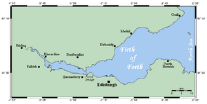
The Isle of May is a small island in Scotland. It sits in the Firth of Forth, about 8 kilometers (5 miles) off the coast. The island is about 1.5 kilometers (1 mile) long and 0.5 kilometers (0.3 miles) wide. NatureScot owns and looks after the island as a special national nature reserve. No one lives there permanently now. However, long ago, it was home to a monastery called St Adrian's Priory.
Many people visit the island for a day trip. They take a ferry from Anstruther in Fife. The journey takes about 45 minutes. You can also catch a ferry from Crail or North Berwick. Around 11,000 people visit the island each year.
The island is closed to visitors from October to Easter. This helps protect the many grey seal pups born there. The Scottish Seabird Centre in North Berwick has live cameras on the island. Visitors can control these cameras to see seabirds and seal pups up close. This way, the animals are not disturbed. The centre also offers boat trips to the Isle of May.
Besides its amazing nature, the Isle of May has a rich history. St Adrian's Chapel is a very old and important building. The Isle of May Lighthouse and its old buildings are also special. These include the Keepers' Houses and the former Lighthouse Beacon.
Contents
Island Landscape and Rocks

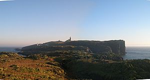
The Isle of May is about 1.5 kilometers (1 mile) long. It is 0.5 kilometers (0.3 miles) wide. The island covers about 57 hectares (140 acres). The western side has tall cliffs, up to 45 meters (148 feet) high. From there, the land slopes down to the eastern shore. This side is mostly rocky. It has three small beaches: Pilgrims Haven, Kirkhaven, and Silver Sands.
In the north, there is a narrow piece of land called Rona. It almost becomes a separate island at high tide. The island's rocks are a dark-grey basalt. This rock has hints of green. The island has many cracks, called faults. Over time, these faults have worn away. They now form steep gullies, known as geos.
Amazing Wildlife on the Isle of May
Even though it's small, over 285 types of birds have been seen here. The island has no foxes or rats. This makes it a safe place for birds to nest and raise their young. During the breeding season, about 200,000 seabirds live on the Isle of May.
These birds include puffins, black-legged kittiwakes, and razorbills. You can also see guillemots, shags, and fulmars. Other birds are oystercatchers, eider ducks, and different kinds of terns and gulls. The number of birds can change each year. This depends on the weather and how many fish are available.
Scientists from the Centre for Ecology and Hydrology study these seabirds. They look at what the birds eat and how many chicks they have. This is part of the Isle of May Long Term Study. They found that birds used to eat mostly sandeels. Now, they eat other types of fish. This change might be because the ocean around the Isle of May is getting warmer.
Many birds visit in winter too. The island is important for turnstones and purple sandpipers. You can also often see pipits, thrushes, and wagtails. Sometimes, rare birds visit the Isle of May. These are birds that usually don't come to Britain. They get blown off course from Scandinavia by strong winds. Recent rare visitors include the black-winged stilt and the lanceolated warbler.
Both harbour seals and grey seals live on the island all year. You might even see whales in the summer. The Isle of May is the second largest breeding place for grey seals on Scotland's east coast. About 3,000 seal pups are born here every year. Minke whales and harbour porpoises are often seen in the waters nearby.
Rabbits have been on the Isle of May since at least 1329. Monks living on the island probably brought them there. The island also has its own special type of house mouse.
Island History and Ancient Stories
The name of the island is a bit of a mystery. It might come from an Old Norse word meaning "island of seagulls." Or, it could be from the Gaelic word Magh, meaning "a plain." Other islands nearby have Gaelic names. The island has names from both languages. For example, "Tarbet" is Gaelic for an isthmus. "Kirkhaven" might be from a Norse word. Some people think the name might also be linked to the Maeatae people. They may have used the island as a burial site for their kings.
The Isle of May had one of Scotland's first Christian churches. It was built in the 9th century. This church was built into a large burial mound. This mound was probably much older, from prehistoric times. Bones found there date from the 7th to 10th centuries. But, Bronze Age funeral urns suggest the mound is even older.
The church on the island today is named after Saint Adrian of May. He was killed on the island by Danish invaders in 875.
The Orkneyinga saga, a Viking story from the 1200s, tells of another Viking raid. Sweyn Asleifsson and Margad Grimsson raided the island. They had been kicked out of Orkney. They stayed on the Isle of May for seven nights because of bad weather. The monks thought they were pirates and sent for help. Sweyn and his men quickly left. They took many treasures from the monastery. They then went to Edinburgh and met King David. The King welcomed Sweyn and Margad. He even paid back the monks for what was stolen.
The original church was made bigger in the 12th century by King David I. A group of Benedictine monks came to live there. They promised to have nine priests on the island. These priests would pray for the souls of the Scottish Kings.
The island was a popular place for pilgrims. They came to visit the shrine of Saint Ethernan. He died there around 669. In the 12th century, it was already important for pilgrims. There are remains of a large ten-seat lavatory. This was much bigger than needed for only nine or ten monks. The priory was later moved to Pittenweem in 1318.
Many important people visited the island. Mary of Guelders came in 1449. King James IV visited in 1506 and 1508. He even shot seabirds with a small cannon. In 1539, Mary of Guise and her husband King James V made a pilgrimage. People believed visiting the shrine could help women become pregnant.
The island changed hands many times after 1549. John Cunningham of Barnes bought it. He built the first lighthouse beacon on the island. In the 1500s, ships with sick people were sent to the island. They had to stay until they were healthy.
The Isle of May was important to local fishing villages. Every year, wives and children from Cellardyke would picnic there. In 1837, a sad accident happened. A small boat overturned, and 13 people died.
A series of accidental crashes happened near the island in 1918. This was called the "Battle of May Island". Several Royal Navy ships collided in the dark. Two submarines sank, and many lives were lost. Other ships were also damaged.
During the Second World War, the Navy had a control center on the island. They used special equipment to find enemy submarines and ships. This lasted until 1946.
Since 1956, the Isle of May has been a National Nature Reserve. NatureScot manages it. They bought the island in 1989.
Lighthouses of the Isle of May
| Tower shape | quadrangular tower with balcony and lantern rising from a 2-storey keeper’s house |
|---|
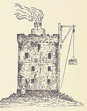
The first beacon on the island was lit in 1635 or 1636. It burned coal. Ship owners had to pay a fee to use it. This was Scotland's first lighthouse that always had people working there. It used about 400 tons of coal each year. Three men were needed to keep it burning.
In 1791, a terrible accident happened. One of the lightkeepers, George Anderson, and his wife and five children died. They were suffocated by fumes. Ash and coal waste had built up around the beacon tower. It caught fire from falling coals.
Sometimes, the light was hard to see. In 1810, two British Navy ships crashed near Dunbar. Their navigators mistook a lime kiln on the mainland for the lighthouse.
The Northern Lighthouse Board bought the island in 1814 for £60,000. By then, the coal beacon was the last private lighthouse in Scotland. A proper lighthouse was built in 1816 by Robert Stevenson. It looks like a gothic castle. It is 24 meters (79 feet) high. It had homes for three lightkeepers and their families. The new lighthouse began working on September 1, 1816. It is now a listed building.
The lighthouse was improved in 1836. More work was done in 1885–1886. New buildings were added, including engine houses and a workshop. Two large steam-powered generators were installed. These powered an electric lamp in the lighthouse. A paraffin lamp was kept ready in case the electric one failed. The new electric light started on December 1, 1886. It flashed four times every 30 seconds.
The electric light used a lot of expensive coal. So, in 1924, it was changed to a gas lamp.
Another smaller lighthouse, the Low Light, was built in 1843. It worked with the main lighthouse. This helped ships avoid the North Carr Rock, 11 kilometers (7 miles) north of the island. It was first used in April 1844. But it is no longer used today. The building is now a place for bird watching.
In 1930, two keepers saved four sailors from a wrecked fishing boat. They swam out to the boat to rescue them. In 1972, the lighthouse became a "rock" station. This meant keepers' families no longer lived on the island. In 1989, it became fully automatic. The Nature Conservancy Council then took over the island. Today, the light is controlled from Edinburgh.
The modern light flashes white twice every 15 seconds. It can be seen up to 41 kilometers (25 miles) away in good weather. The island also had fog signals from two buildings. These were powered by compressed air. They were stopped in 1989. The May lighthouse was mentioned in John Buchan's 1934 novel The Free Fishers.
Protecting the Isle of May
| Isle of May National Nature Reserve | |
|---|---|
|
IUCN Category II (National Park)
|
|
| Location | Firth of Forth, Scotland |
| Area | 56.6 ha (140 acres) |
| Established | 1956 |
| Governing body | NatureScot |
| Isle of May National Nature Reserve | |
The Isle of May became a national nature reserve in 1956. The Nature Conservancy and its later groups, like NatureScot, have managed the island since then. NatureScot now owns the island.
The Isle of May has many other important protections for its wildlife:
- It is a Forth Islands Special Protection Area (SPA).
- It is an Isle of May Site of Special Scientific Interest (SSSI).
- It is an Isle of May Special Area of Conservation (SAC).
- It is also a Category II protected area. This is a special international ranking.
 | Roy Wilkins |
 | John Lewis |
 | Linda Carol Brown |


