Jackson County, Ohio facts for kids
Quick facts for kids
Jackson County
|
|||
|---|---|---|---|

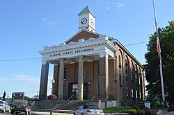
Jackson County Courthouse
|
|||
|
|||

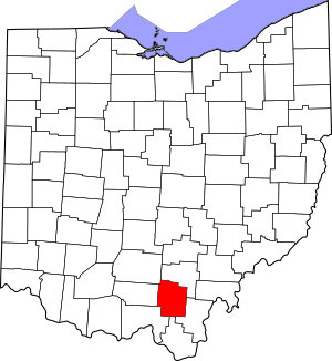
Location within the U.S. state of Ohio
|
|||
 Ohio's location within the U.S. |
|||
| Country | |||
| State | |||
| Founded | March 1, 1816 | ||
| Named for | Andrew Jackson | ||
| Seat | Jackson | ||
| Largest city | Jackson | ||
| Area | |||
| • Total | 422 sq mi (1,090 km2) | ||
| • Land | 420 sq mi (1,100 km2) | ||
| • Water | 1.2 sq mi (3 km2) 0.3%% | ||
| Population
(2020)
|
|||
| • Total | 32,653 |
||
| • Density | 77/sq mi (30/km2) | ||
| Time zone | UTC−5 (Eastern) | ||
| • Summer (DST) | UTC−4 (EDT) | ||
| Congressional district | 2nd | ||
Jackson County is a place in the state of Ohio, USA. In 2020, about 32,653 people lived there. The main town and government center is Jackson.
The county is named after Andrew Jackson. He was a brave hero in the War of 1812. Later, he became a U.S. President. Jackson County is also called "The Little Wales of Ohio."
Contents
History of Jackson County
Jackson County is in eastern Ohio, north of the Ohio River. Long ago, different groups of Native Americans lived here. You can still find signs of them, like large burial mounds and rock carvings called petroglyphs. One famous example is the Leo Petroglyph.
During the time when Europeans first came to America, tribes like the Mingo, Lenape, and Shawnee lived in this area. Later, American settlers moved west. This meant that the Indigenous People were forced to leave their homes. Many were moved to new lands far away.
The new settlers cleared the land to start farming. They also built towns and developed industries. This helped the area grow.
Iron and Coal Industries
In the mid-1800s, people found iron ore in southern Ohio. There were also many large forests. These forests provided charcoal to heat the furnaces. This made the Hanging Rock Iron Region perfect for making iron.
The Jefferson Iron Furnace was built in 1854. It made iron for the growing United States. The iron furnaces became very important during the American Civil War. Iron from Jackson County was sold as "Anchor" brand. This iron was used to build the USS Monitor. This was a famous iron warship that fought against the Confederate ship, the CSS Virginia, in a big battle.
After the Civil War, the iron industry in Jackson County slowly ended. There wasn't enough iron ore left, and most of the forests had been cut down for charcoal. Today, you can still see parts of the Jefferson Iron Furnaces at Jackson Lake State Park.
Other important industries were coal mining and salt mining. In 1888, over a million tons of coal were mined. Jackson County was the second-biggest coal producer in Ohio back then. Salt mines along Salt Creek were also very important. Native American tribes traveled long distances to get salt from this area.
Geography
Jackson County covers about 422 square miles. Most of this area, about 420 square miles, is land. Only a small part, about 1.2 square miles, is water.
Neighboring Counties
Jackson County shares borders with these other counties:
- Vinton County (to the north)
- Gallia County (to the east)
- Lawrence County (to the south)
- Scioto County (to the southwest)
- Pike County (to the west)
- Ross County (to the northwest)
Protected Natural Areas
Part of the Wayne National Forest is located in Jackson County. This is a large protected area.
Population Over Time
| Historical population | |||
|---|---|---|---|
| Census | Pop. | %± | |
| 1820 | 3,746 | — | |
| 1830 | 5,941 | 58.6% | |
| 1840 | 9,744 | 64.0% | |
| 1850 | 12,719 | 30.5% | |
| 1860 | 17,941 | 41.1% | |
| 1870 | 21,759 | 21.3% | |
| 1880 | 23,686 | 8.9% | |
| 1890 | 28,408 | 19.9% | |
| 1900 | 34,248 | 20.6% | |
| 1910 | 30,791 | −10.1% | |
| 1920 | 27,342 | −11.2% | |
| 1930 | 25,040 | −8.4% | |
| 1940 | 27,004 | 7.8% | |
| 1950 | 27,767 | 2.8% | |
| 1960 | 29,372 | 5.8% | |
| 1970 | 27,174 | −7.5% | |
| 1980 | 30,592 | 12.6% | |
| 1990 | 30,230 | −1.2% | |
| 2000 | 32,641 | 8.0% | |
| 2010 | 33,225 | 1.8% | |
| 2020 | 32,653 | −1.7% | |
| U.S. Decennial Census 1790-1960 1900-1990 1990-2000 2020 |
|||
In 2010, there were 33,225 people living in Jackson County. About 97% of the people were white. Other groups included Black or African American, American Indian, and Asian people. About 1.4% of the people were from two or more races.
The average age of people in the county was 39 years old. About 34% of households had children under 18 living with them.
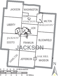
Communities
Cities
Villages
Townships
- Bloomfield
- Coal
- Franklin
- Hamilton
- Jackson
- Jefferson
- Liberty
- Lick
- Madison
- Milton
- Scioto
- Washington
Unincorporated Communities
These are smaller places that are not officially cities or villages.
- Altoona
- Banner
- Big Rock
- Blackfork Junction
- Brocks Corner
- Buckeye
- Buffalo
- Byer
- Camba
- Chapman
- Clay
- Comet
- Davisville
- Englishville
- Four Mile
- Garfield
- Glade
- Glen Nell
- Glen Roy
- Goldsboro
- Horeb
- Ironton Junction
- Jackson Heights
- Jonestown
- Keystone
- Kitchen
- Leo
- Lesmil
- Limerick
- Mabee Corner
- Monroe
- Mulga
- Oakland
- Orpheus
- Pattonsville
- Petersburg
- Petrea
- Pyro
- Ratchford
- Rempel
- Roads
- Rocky Hill
- Savageville
- Tom Corwin
- Wainwright
- Winchester
- Vega
See also
 In Spanish: Condado de Jackson (Ohio) para niños
 | Selma Burke |
 | Pauline Powell Burns |
 | Frederick J. Brown |
 | Robert Blackburn |


