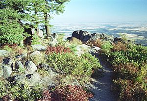
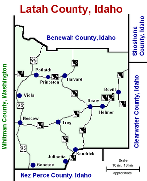
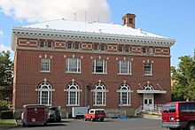
Latah County, Idaho facts for kids
Quick facts for kids
Latah County
|
||
|---|---|---|
|
||
|
||
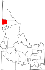
Location within the U.S. state of Idaho
|
||
 Idaho's location within the U.S. |
||
| Country | ||
| State | ||
| Founded | May 14, 1888 | |
| Named for | Latah Creek | |
| Seat | Moscow | |
| Largest city | Moscow | |
| Area | ||
| • Total | 1,077 sq mi (2,790 km2) | |
| • Land | 1,077 sq mi (2,790 km2) | |
| • Water | 0.9 sq mi (2 km2) 0.09% | |
| Population
(2020)
|
||
| • Total | 39,517 | |
| • Density | 36.692/sq mi (14.167/km2) | |
| Time zone | UTC−8 (Pacific) | |
| • Summer (DST) | UTC−7 (PDT) | |
| Congressional district | 1st | |
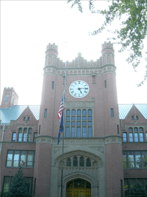
Latah County is a county located in the north central part of Idaho. In 2020, about 39,517 people lived here. The main city and county seat is Moscow. This city is also home to the University of Idaho, which is a very important university for the state.
The county was created in 1888. It was named after Latah Creek, which is in the northwest part of the county. The name "Latah" comes from two words in the Nez Perce language. These words mean "the place of pine trees and sestle." The Nez Perce tribe used to find shade under the white pine trees. They also found special stones there to grind camas roots. Camas roots were an important food for them.
Latah County is part of the Moscow, ID Micropolitan Statistical Area. This area is also included in the Pullman-Moscow, WA-ID Combined Statistical Area.
Most of the eastern part of Latah County is known as the Palouse. This area is famous for its rolling hills and rich farmland. Latah County is special because it is the only county in the U.S. that was created by an act of the U.S. Congress. It used to be part of Nez Perce County. However, Nez Perce County did not want to lose its most populated area.
Contents
History of Latah County
Early Settlements
American settlers began arriving in the Palouse region in 1871. The first towns to grow were Genesee and Moscow. Later, Juliaetta and Kendrick also started to develop in the 1880s. When the railroad reached Moscow in 1885, it helped the city become the biggest center in the county. The University of Idaho was started in Moscow in 1889. This also helped the city continue to grow. Other towns like Troy began to be settled in 1895, and Bovill in 1899. A railroad was built from Moscow to Bovill in 1907. The town of Deary grew up along this railroad that same year. Potlatch was founded as a company town in 1905.
How Cities Grew
Moscow first appeared in the 1880 census with 76 people. It became an official village in 1887. Genesee was established as a town in 1889. By 1900, Juliaetta, Kendrick, and Troy were also towns. They all became official villages before 1910. Bovill and Deary became villages before 1920. Potlatch and Onaway stayed as unincorporated areas for a long time.
How County Borders Changed
In 1864, the Idaho Territorial Legislature created two counties: Lah-Toh and Kootenai. Lah-Toh covered all of northern Idaho west of Shoshone County. Coeur d'Alene was named the county seat of Lah-Toh County. However, there were not enough people living in the area to support a county government.
Later, in 1867, the legislature canceled the creation of these two counties. They made the northern border of Nez Perce County the same as Latah County's current northern border. The rest of Lah-Toh was put into Kootenai County.
In 1878, people in Moscow tried to organize Lah-Toh County, not knowing it had been canceled. The Governor first agreed, but then told them they were actually in Nez Perce County. The Idaho Territorial Legislature did not create a new county for the people of Moscow. So, Fred T. Dubois asked the United States Congress to create the county for them. On May 14, 1888, Latah County was officially created with Moscow as its seat. This makes Latah County the only U.S. county ever created by the United States Congress!
Geography of Latah County
Latah County covers about 1,077 square miles. Most of this area is land, with only a small amount of water. It is part of the Palouse region. The Palouse is a large area of rolling hills in the middle of the Columbia basin.
Neighboring Counties
- Benewah County – to the north
- Shoshone County – to the northeast
- Clearwater County – to the east
- Nez Perce County – to the south
- Whitman County, Washington – to the west
Main Roads
Protected Natural Areas
- St. Joe National Forest (part of it is in Latah County)
Population Facts
| Historical population | |||
|---|---|---|---|
| Census | Pop. | %± | |
| 1890 | 9,173 | — | |
| 1900 | 13,451 | 46.6% | |
| 1910 | 18,818 | 39.9% | |
| 1920 | 18,092 | −3.9% | |
| 1930 | 17,798 | −1.6% | |
| 1940 | 18,804 | 5.7% | |
| 1950 | 20,971 | 11.5% | |
| 1960 | 21,170 | 0.9% | |
| 1970 | 24,891 | 17.6% | |
| 1980 | 28,749 | 15.5% | |
| 1990 | 30,617 | 6.5% | |
| 2000 | 34,935 | 14.1% | |
| 2010 | 37,244 | 6.6% | |
| 2020 | 39,517 | 6.1% | |
| 2023 (est.) | 41,301 | 10.9% | |
| U.S. Decennial Census 1790–1960 1900–1990 1990–2000 2010–2020 2020 |
|||
In 2010, there were 37,244 people living in Latah County. The population density was about 34.6 people per square mile. Most people living in the county were white. About 3.6% of the population was of Hispanic or Latino origin. The average age of people in Latah County was 28.3 years old.
Plants and Animals
Latah County is home to many different kinds of plants and animals. Some of the trees you can find here include the Western White Pine. Animals that live in the county include the Clay-colored sparrow and the Rough-Skinned Newt.
Communities in Latah County
Cities
Census-Designated Places (CDPs)
These are areas that are like towns but are not officially incorporated as cities.
Unincorporated Communities
These are small communities that do not have their own local government.
|
Ghost Towns
These are towns that used to exist but are now abandoned.
|
|
|
|
Education in Latah County
There are several school districts in Latah County:
- Genesee Joint School District 282
- Kendrick Joint School District 283
- Moscow School District 281
- Potlatch School District 285
- Troy School District 287
- Whitepine Joint School District 288
For higher education, students can attend the University of Idaho.
See also
 In Spanish: Condado de Latah para niños
 | Calvin Brent |
 | Walter T. Bailey |
 | Martha Cassell Thompson |
 | Alberta Jeannette Cassell |


