Lawrence County, Ohio facts for kids
Quick facts for kids
Lawrence County
|
|||
|---|---|---|---|

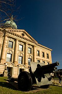
Lawrence County Courthouse
|
|||
|
|||

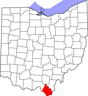
Location within the U.S. state of Ohio
|
|||
 Ohio's location within the U.S. |
|||
| Country | |||
| State | |||
| Founded | March 1, 1817 | ||
| Named for | James Lawrence | ||
| Seat | Ironton | ||
| Largest city | Ironton | ||
| Area | |||
| • Total | 457 sq mi (1,180 km2) | ||
| • Land | 453 sq mi (1,170 km2) | ||
| • Water | 3.9 sq mi (10 km2) 0.9%% | ||
| Population
(2020)
|
|||
| • Total | 58,240 |
||
| • Density | 130/sq mi (50/km2) | ||
| Time zone | UTC−5 (Eastern) | ||
| • Summer (DST) | UTC−4 (EDT) | ||
| Congressional district | 2nd | ||
Lawrence County is the southernmost county in Ohio, a state in the United States. In 2020, about 58,240 people lived there. The main town, or county seat, is Ironton. The county was officially formed in 1817. It's named after James Lawrence, a brave naval officer who famously said, "Don't give up the ship!" Lawrence County is also part of a larger area called the Huntington–Ashland metropolitan area.
Contents
Exploring Lawrence County's Past
The first European-American settlers arrived in Lawrence County around 1796. Luke Kelly and his family, along with May Keyser, settled near Hanging Rock along the Ohio River.
Lawrence County was officially created on December 20, 1816. It was formed from parts of two other counties: Gallia and Scioto. The first county seat was a town called Burlington.
Moving the County Seat
In 1851, the county seat was moved from Burlington to Ironton. A new courthouse was built in Ironton at that time. Sadly, this courthouse burned down in 1857. The beautiful Lawrence County Courthouse you see today was built much later, in 1908.
Lawrence County in Wars
Men from Lawrence County have bravely served in many wars throughout history. Some men from the county fought in the Mexican–American War.
During the American Civil War, which happened between 1861 and 1865, about 3,200 men from Lawrence County joined the Union Army. This was a large number of soldiers from the county.
Later, during World War I, which took place from 1914 to 1918, about 2,200 men from Lawrence County served in the armed forces. Ninety-nine of these brave soldiers died during the war.
Where is Lawrence County?
Lawrence County covers a total area of about 457 square miles. Most of this area, about 453 square miles, is land. The remaining 3.9 square miles, or about 0.9%, is water.
It is the southernmost county in the state of Ohio. Lawrence County is also part of a region known as Appalachian Ohio, which includes parts of the Appalachian Mountains.
Neighboring Counties
Lawrence County shares its borders with several other counties:
- To the north: Jackson County
- To the northeast: Gallia County
- To the southeast: Cabell County, West Virginia (in West Virginia)
- To the south: Wayne County, West Virginia (in West Virginia)
- To the southwest: Boyd County, Kentucky (in Kentucky)
- Also to the southwest: Greenup County, Kentucky (in Kentucky)
- To the northwest: Scioto County
Protected Natural Areas
Part of the Wayne National Forest is located within Lawrence County. This is a large protected area of forests and natural beauty.
People of Lawrence County
| Historical population | |||
|---|---|---|---|
| Census | Pop. | %± | |
| 1820 | 3,499 | — | |
| 1830 | 5,367 | 53.4% | |
| 1840 | 9,738 | 81.4% | |
| 1850 | 15,246 | 56.6% | |
| 1860 | 23,249 | 52.5% | |
| 1870 | 31,380 | 35.0% | |
| 1880 | 39,068 | 24.5% | |
| 1890 | 39,556 | 1.2% | |
| 1900 | 39,534 | −0.1% | |
| 1910 | 39,488 | −0.1% | |
| 1920 | 39,540 | 0.1% | |
| 1930 | 44,541 | 12.6% | |
| 1940 | 46,705 | 4.9% | |
| 1950 | 49,115 | 5.2% | |
| 1960 | 55,438 | 12.9% | |
| 1970 | 56,868 | 2.6% | |
| 1980 | 63,849 | 12.3% | |
| 1990 | 61,834 | −3.2% | |
| 2000 | 62,319 | 0.8% | |
| 2010 | 62,450 | 0.2% | |
| 2020 | 58,240 | −6.7% | |
| U.S. Decennial Census 1790-1960 1900-1990 1990-2000 2020 |
|||
In 2010, there were 62,450 people living in Lawrence County. These people lived in about 24,974 households. The population density was about 137.7 people per square mile.
Most of the people in Lawrence County, about 95.9%, were white. About 2.0% were Black or African American, and smaller percentages were Asian, American Indian, or from other backgrounds. About 0.7% of the population identified as Hispanic or Latino.
The average age of people in Lawrence County in 2010 was 40.1 years old. About 32.9% of households had children under 18 living with them.
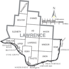
Communities in Lawrence County
City
- Ironton (This is the main town and county seat.)
Villages
Townships
- Aid
- Decatur
- Elizabeth
- Fayette
- Hamilton
- Lawrence
- Mason
- Perry
- Rome
- Symmes
- Union
- Upper
- Washington
- Windsor
Census-designated places
These are areas that are like towns but are not officially incorporated as cities or villages.
- Burlington
- Miller
Unincorporated communities
These are smaller communities that are not officially part of a city or village.
- Eifort
- Etna
- Firebrick
- Kitts Hill
- Pedro
- Rock Camp
- Scottown
- Waterloo
- Willow Wood
See also
 In Spanish: Condado de Lawrence (Ohio) para niños


