
Leggetts Creek facts for kids
Quick facts for kids Leggetts Creek |
|
|---|---|

Leggetts Creek 4,300 feet (1,300 m) upstream of its mouth
|
|
| Other name(s) | Legget Creek, Leggett's Gap Creek, Leggits Creek, Liggett's Creek |
| Physical characteristics | |
| Main source | wetland in Scott Township, Lackawanna County, Pennsylvania between 1,600 and 1,620 feet (490 and 490 m) |
| River mouth | Lackawanna River in Scranton, Lackawanna County, Pennsylvania 715 ft (218 m) 41°26′41″N 75°38′36″W / 41.44482°N 75.64331°W |
| Length | 9.0 mi (14.5 km) |
| Basin features | |
| Progression | Lackawanna River → Susquehanna River → Chesapeake Bay |
| Basin size | 18.5 sq mi (48 km2) |
| Tributaries |
|
Leggetts Creek is a stream about 9 miles (14.5 km) long in Lackawanna County, Pennsylvania. It flows into the Lackawanna River. People also know it by other names like Legget Creek or Liggett's Creek.
The creek starts in a wet, marshy area in Scott Township. It then flows through Scott Township, South Abington Township, and Scranton. The area of land that drains into Leggetts Creek is about 18.5 square miles (47.9 square kilometers).
Leggetts Creek has three main smaller streams that flow into it: Leach Creek, Clover Hill Creek, and Summit Lake Creek. Even though the creek is affected by city growth, it's not harmed by acid from old mines. The water is usually a bit alkaline (the opposite of acidic) and flows all year round.
The creek begins in wetlands outside the Lackawanna Valley. It flows through a narrow valley called Leggetts Gap or The Notch. Important lakes in this area include Griffin Reservoir, Summit Lake, and Maple Lake. Griffin Reservoir is used to supply drinking water. Sometimes, Leggetts Creek can cause flooding in South Abington Township.
Long ago, a Native American path followed Leggetts Creek through its water gap. This path connected the Lehigh River to the Susquehanna River. In the past, there were some mining and quarrying activities in the area. A railroad, the Liggett's Gap Railroad, was built here and opened in 1851. Many bridges have been built over the creek over the years.
Wild trout live and reproduce naturally in Leggetts Creek. Other fish species have also been seen there. Some parts of the creek have old-growth forests along their banks, which help protect the water. Other areas have grasslands or plants that are not native to the region. There's a plan to create a walking and biking trail along the creek.
Contents
Where Leggetts Creek Flows

Leggetts Creek starts in a wetland (a marshy area) in Scott Township. It flows southwest for a short distance, then turns south and runs next to Pennsylvania Route 347. After more than a mile, it goes past the community of Justus and turns west.
The creek then passes the Griffin Reservoir and enters South Abington Township. From the reservoir, it flows southwest for over a mile. Then it turns south-southwest and goes under Interstate 81. After a bit, a stream called Summit Lake Creek joins it from the right side, and Leggetts Creek turns southeast.
For the next few miles, the creek flows next to US Route 6 and Interstate 81. It goes through a narrow valley called a water gap between West Mountain and Bell Mountain. In this gap, the creek eventually turns south and enters Scranton. Then it turns south-southeast, leaving the water gap. Here, Clover Hill Creek joins it from the left.
The creek then flows south-southwest for a short distance before Leach Creek, its last named tributary, joins it from the right. Leggetts Creek then turns east, then north for a short way, and then east again. After a few hundred feet, it meets the Lackawanna River.
Leggetts Creek joins the Lackawanna River about 14.36 miles (23.11 km) upstream from the Lackawanna River's own mouth.
Streams That Join Leggetts Creek
Leggetts Creek has three main streams that flow into it: Leach Creek, Clover Hill Creek, and Summit Lake Creek.
- Leach Creek joins Leggetts Creek about 1 mile (1.6 km) upstream from its mouth. The area that drains into Leach Creek is about 2.55 square miles (6.6 square kilometers).
- Summit Lake Creek joins Leggetts Creek about 3.9 miles (6.3 km) upstream from its mouth. The area that drains into Summit Lake Creek is about 3.08 square miles (7.98 square kilometers).
Leggetts Creek also has many smaller streams that flow into it. These smaller streams have local names, but they are not officially named.
Water Quality of Leggetts Creek
The Pennsylvania Department of Environmental Protection says that Leggetts Creek is not as clean as it could be. This is mainly because of urban development, meaning more buildings and roads in the area.
Sometimes, the creek's water quality might not meet standards, especially when the water flow is low or during summer. There are some issues with water from old mines affecting the creek in certain areas. The creek can lose some of its water into underground mine tunnels. In 1978, experts thought the creek lost 20 to 30 percent of its water to mines during dry times. However, the creek is big enough that this doesn't harm the animals living in it too much.
A sewage treatment plant in Chinchilla releases treated water into the creek. In its lower parts, the creek is affected by past mining, city growth, and trash. Rainwater runoff (called stormwater) also flows into the creek and carries fine dirt.
Leggetts Creek is used for certain purposes, but its water and the places where animals live are greatly affected. This also contributes to the pollution of the Lackawanna River. The main reason for this is city growth, not pollution from abandoned mines. The creek flows all year round. A study in 2009 said the creek showed "some degraded conditions," meaning it wasn't in perfect shape.
Leggetts Creek has fairly high levels of total dissolved solids (minerals and other stuff dissolved in the water) and electrical conductivity (how well water conducts electricity). The water is also a bit alkaline, with a pH that usually averages around 8.20. The saltiness (salinity) of the water averages 345 parts per million. While this is within safe limits, a study in 2013/2014 suggested trying to reduce the saltiness.
The amount of dissolved oxygen in Leggetts Creek varies a lot, but on average, it's good for aquatic life. In 2001, the creek had high levels of nutrients like nitrates and phosphates, and also sodium. However, in 2008, the creek didn't show much overall harm.
The highest amount of water that flows in Leggetts Creek each year (called peak annual discharge) has a 10% chance of reaching 2180 cubic feet per second near its mouth. This means there's a 1 in 10 chance it will flow that fast in any given year.
Land and Climate Around the Creek

The land near where Leggetts Creek meets the Lackawanna River is about 715 feet (218 meters) above sea level. The creek starts much higher, between 1600 and 1620 feet (488 and 494 meters) above sea level. In 2013, the creek was about 18 feet (5.5 meters) wide on average.
Leggetts Creek flows through a narrow valley called Leggetts Gap or The Notch. This gap is cut through the West or Lackawanna Mountain Range by the creek. There have been piles of waste coal (called culm) along the creek, and old mining operations have affected it. The creek's source is in wetlands surrounded by homes.
In Leggetts Gap, where the creek flows near major highways, there are rocks and concrete (called riprap) along its banks to prevent erosion. In some lower parts, the creek has a natural path and gentle slopes. However, in other places, dirt and debris have been dumped on its banks, making them steep. In South Abington Township, parts of the creek have been straightened or changed by humans.
There are waterfalls and cascades (small waterfalls) on a section of Leggetts Creek. This is from the Griffin Reservoir down to a dam about three-quarters of a mile away. These waterfalls are made by natural rock ledges, large rocks, and the remains of an old mill. A project has been done to stabilize the creek banks at South Abington Park. The creek flows through 51 pipes (culverts) that range in size from 3 to 36 inches (7.6 to 91 cm).
The headwaters (where the creek begins) of Leggetts Creek are outside the main Lackawanna Valley. Long ago, before the ice age, the creek flowed differently. Now, its path has changed, and the old path is covered by buildings. There's a rock ledge on the north bank of the creek in its lower parts. The creek makes a sharp turn eastward around a place called Providence. From there to its mouth, it flows through a rocky channel.
A small dam called the High Service Dam is on Leggetts Creek in Scranton. It's about 12 feet (3.7 meters) wide.
A rock formation called the Campbell's Ledge Black Shale is found near Leggetts Creek. This formation contains shale and coal. In the early 1900s, a large amount of sandy dirt (called till) was found on the ledge on the northern bank of the creek.
In early March 2013, the temperature near Leggetts Creek was about 42°F (5.6°C). A study in 2013/2014 found the water temperature of the creek ranged from 0.97°C to 22.64°C (33.7°F to 72.8°F), with an average of 11.62°C (52.9°F).
Leggetts Creek Watershed
The watershed (the entire area of land that drains water into the creek) of Leggetts Creek is about 18.5 square miles (47.9 square kilometers). It's one of the larger streams that flows into the Lackawanna River. The mouth of the creek is in the Scranton area, but its source is in the Dalton area. Leggetts Creek is considered a "third-order" stream, meaning it's a medium-sized stream formed by smaller streams joining together. It's the third-largest tributary of the Lackawanna River.
The watershed includes parts of several towns and townships: Scott Township, South Abington Township, Abington Township, Clarks Green, Clarks Summit, Newton Township, Dickson City, and Scranton.
Most of the land in the Leggetts Creek watershed is used for homes, businesses, and open spaces.
Lakes in the watershed include the Griffin Reservoir, Maple Lake, and Summit Lake. These are in South Abington Township and Scott Township. The Griffin Reservoir provides drinking water to over 100,000 people in the area. A spring called Fountain Springs is also in the watershed. Most of the watershed is developed, but some parts of the creek are still natural.
Some land along the creek's floodplain (the flat area next to the creek that can flood) is owned by the city of Scranton. There are also areas of abandoned mine land near the creek in northern Scranton. These areas might be developed in the future. Many of the neighborhoods in the watershed are historic residential areas built between 1870 and 1920.
Leggetts Creek can cause flooding in South Abington Township, often affecting properties in low-lying areas.
History and Name of the Creek

Leggetts Creek was officially added to the Geographic Names Information System on August 30, 1990. It's also known as Legget Creek, Leggett's Gap Creek, and Leggits Creek. The creek is named after James Leggett, one of the first settlers in the area in the 1770s.
A historic Native American path used to go through the water gap of Leggetts Creek. This path connected the Lehigh River to the Great Bend on the Susquehanna River, near the Pennsylvania/New York border. In 1826, Thomas Meredith thought of building a railroad from the mouth of the creek to the Great Bend, a distance of 48 miles (77 km). This railroad eventually became known as the "Leggetts Gap Railroad" and opened in 1851.
The Rockwell Mine at Leggetts Gap opened in 1854. The Leggetts Creek Colliery (a coal mine) was working in the early 1900s. Also, a rock ledge near the creek was heavily quarried (mined for stone) in the early 1900s.
Many bridges have been built over Leggetts Creek. For example:
- A stone arch bridge built in 1905 carries North Main Street over the creek.
- A concrete bridge built in 1936 carries US Route 11 over the creek.
- Several bridges for Interstate 81 and its ramps were built in the 1960s.
- Newer bridges, like one for Mary Street (1979) and one for T-422/Burcher Ave (2009), have also been constructed.
In the late 1960s, there was a plan to clean up Leggetts Creek by dredging (removing mud and debris) to fix damage from old mining. In 1991, a group called the Lackawanna River Corridor Association collected information on the creek's water and animal habitats. In 2012, the South Abington Sewer Authority started upgrading its sewage treatment plant to prevent dirty water and too many nutrients from entering the creek.
PA Trout Unlimited studied the fish in the creek in November 2013. The Lackawanna Valley Conservancy received a grant to create the Leggetts Creek Greenway, a trail along the creek.
Historic places in the watershed include Griffins Mills in South Abington. The Aladdin Plating site, also in South Abington, is a Superfund site, meaning it's a place with hazardous waste that needs cleaning up. In the early 2000s, a plan suggested that local towns should protect Leggetts Creek in their zoning plans.
Animals and Plants of Leggetts Creek
Wild trout naturally reproduce in Leggetts Creek, from Summit Lake Creek down to its mouth, a distance of about 3.6 miles (5.8 km). The creek is also stocked with trout (meaning trout are added by people), and other non-game fish species live there too. The parts of the creek upstream of Summit Lake Creek are good for coldwater fish and migrating fish. From Summit Lake Creek downstream, it's a place where trout are stocked and where migrating fish can be found.
In a 2013 fish survey of the creek, nine brown trout were found. Their lengths ranged from 84 to 316 millimeters (about 3.3 to 12.4 inches). Most were smaller, around 75 to 99 millimeters (3 to 3.9 inches). The population density was 164 trout per hectare (about 66 trout per acre).
In the same survey, brown trout and cutlips minnow were the most common fish. Other fish like bluegill, eastern blacknose dace, longnose dace, and largemouth bass were also present. Less common fish included brown bullhead, flatnose minnow, and pumpkinseed.
The plants along the Griffin Reservoir on Leggetts Creek include various native trees and smaller plants that grow under the trees. From the reservoir downstream, the area along the creek (called the riparian buffer) has old growth forest. This includes tall tulip poplar trees, hemlock, and pine trees.
Near Leggetts Gap, the creek has some natural plant buffers along its banks. Even in its lower parts, some areas have stable plant cover. However, other areas are full of invasive plants, which are not native and can harm the local ecosystem. Common invasive plants include Japanese knotweed, Norway Maple, and Ailanthus. Overall, the areas along the creek are mostly grasslands and forests.
Scientists study tiny creatures without backbones (called macroinvertebrates) in the creek to check its health. The number of different types of these creatures, especially certain sensitive ones like mayflies, stoneflies, and caddisflies (called EPT Taxa), shows how healthy the water is. The creek's habitat was rated as "optimal" in some areas, meaning it's a very good place for aquatic life.
Fun Things to Do at Leggetts Creek
A plan called the Lackawanna River Watershed Conservation Plan suggested creating a greenway (a natural area with trails) along Leggetts Creek. This greenway would be called the Leggetts Creek greenway. It could connect to the Lackawanna River Heritage Trail and possibly extend to another greenway.
South Abington Park and the Leggetts Creek Trail are in Chinchilla, and the creek flows through the trail. Trestle Hole Park is also along the lower parts of the creek. The Dutch Gap Little League Field is located near Wells Street, close to the creek.
Images for kids
-
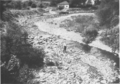
Leggetts Creek 4,300 feet (1,300 m) upstream of its mouth
-
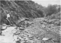
Leggetts Creek 1,300 feet (400 m) upstream of its mouth
-
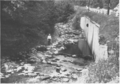
Leggetts Creek 12,000 feet (3,700 m) upstream of its mouth
-
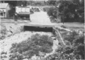
Leggetts Creek flowing under a bridge 300 feet (91 m) upstream of its mouth
