
MacGillycuddy's Reeks facts for kids
Quick facts for kids MacGillycuddy's Reeks |
|
|---|---|
| Irish: Na Cruacha Dubha | |
 |
|
| Highest point | |
| Peak | Carrauntoohil |
| Elevation | 1,038.6 m (3,407 ft) |
| Dimensions | |
| Length | 19 km (12 mi) East–West |
| Naming | |
| English translation | the black stacks |
| Language of name | Irish |
| Geography | |

MacGillycuddy's Reeks
Location in island of Ireland
|
|
| Location | County Kerry |
| Country | Ireland |
| Provinces of Ireland | Munster |
| Topo map | OSI Discovery 78 |
| Geology | |
| Age of rock | Devonian |
| Mountain type | Purple sandstone & siltstone |
The MacGillycuddy's Reeks (which means "the black stacks" in Irish) is a famous mountain range in County Kerry, Ireland. It stretches for about 19 kilometers (12 miles) from the Gap of Dunloe in the east to Glencar in the west.
This range is the highest in Ireland. It has most of the tallest peaks and sharpest ridges in the country. It also has the only mountains in Ireland that are taller than 1,000 meters (3,281 feet).
Right in the middle of the range is Carrauntoohil. This is Ireland's highest mountain, standing at 1,038.6 meters (3,407 feet) tall.
Long ago, huge glaciers shaped these mountains. They carved out deep, bowl-shaped valleys called corries. An example is the Eagle's Nest. They also made U-shaped valleys, like Lough Coomloughra. The glaciers also created sharp, narrow ridges called arêtes, such as the Beenkeragh Ridge.
The MacGillycuddy's Reeks are a very popular place for hiking and climbing. Some of Ireland's best walking trails are here. These include the 15-kilometer (9-mile) Coomloughra Horseshoe and the 26-kilometer (16-mile) MacGillycuddy's Reeks Ridge Walk. It's thought that over 140,000 people visit the range every year. Even though the land is privately owned, people are generally allowed to visit for fun.
Contents
How the Mountains Were Formed: Geology
The MacGillycuddy's Reeks are made of a type of rock called Old Red Sandstone. This rock formed between 310 and 450 million years ago. Back then, Ireland was near the equator and had a hot climate.
During that time, Ireland was a large basin, like a giant bowl, called the Munster basin. The areas that are now Cork and Kerry were a big floodplain. This means they were flat lands often covered by rivers.
Chemical changes stained the rocks a purple-red color. You can still see this color today. Sometimes, they are green too. There are almost no fossils in the Old Red Sandstone. The rock is a mix of different materials. It has quartz stones, mudstones, siltstones, and sandstone particles. You can even see large rocks called conglomerate rock with quartz pebbles in them.
Later, huge glaciers moved across the Reeks. This caused the rock to crack. It also created the deep corries like the Eagle's Nest. The glaciers also formed U-shaped valleys, such as Lough Coomloughra. They also made the sharp arêtes and ridges, like the Beenkeragh Ridge.
Where Are the Mountains: Geography
_-_geograph.org.uk_-_1434579.jpg)
The MacGillycuddy's Reeks are often divided into two main parts. These parts contain all ten of the Reeks that are taller than 3,000 feet (914 meters):
- Eastern Reeks: This is a high ridge that connects Cnoc an Chuillinn, Maolán Buí, Cnoc na Péiste, The Big Gun, and Cruach Mhór (from west to east).
- Coomloughra Reeks: This part forms a horseshoe shape around Lough Coomloughra. It connects Caher (West Top), Caher, Carrauntoohil, The Bones, and Beenkeragh.
The Eastern Reeks and the Coomloughra Reeks meet at a low point called the Devil's Ladder. This is a popular path for climbing Carrauntoohil.
The MacGillycuddy's Reeks has the three tallest peaks in Ireland. These are:
- Carrauntoohil, Ireland's highest mountain at 1,038.6 meters (3,407 feet).
- Beenkeragh at 1,008 meters (3,308 feet).
- Caher at 1,000 meters (3,281 feet).
The range also has eleven of the fourteen peaks in Ireland that are over 3,000 feet (914 meters) tall. These peaks are also known as Irish Munros.
The Reeks are also known for their sharp ridges. These include The Bones ridge, which is more famously known as the Beenkeragh Ridge, and The Big Gun ridge.
One special thing about the Reeks is that many of its peaks are very close in height. This means the ridges between the peaks stay at a high level for a long time. This makes ridge walking very popular in the Reeks. Famous ridge walks include the Coomloughra Horseshoe and the MacGillycuddy's Reeks Ridge Walk. This is why it's called "Ireland's highest mountain range".
Who Owns the Mountains: Ownership
The entire MacGillycuddy's Reeks mountain range is privately owned. Some parts are owned by individuals, especially the lower areas. Other parts are commonly owned by groups, especially the open mountain areas.
Unlike many other large mountain ranges, the MacGillycuddy's Reeks is not a national park. This means there isn't one big organization in charge of looking after it.
Because of this private ownership, there have been some challenges. For example, popular paths like the Devil's Ladder, which climbers use to reach Carrauntoohil, can get worn down. Car parks and bridges used by climbers also need care.
In 2014, a group called the MacGillycuddy Reeks Mountain Access Forum was created. This group includes landowners, businesses, and walking groups. Their goal is to protect and manage the mountain range. They also want to stop and fix the path erosion. This group has had some success. For example, they have laid new paths in the Hag's Glen area, which is a common way to approach Carrauntoohil.
How the Mountains Got Their Name: Naming
The Irish name for the range is Cruacha Dubha Mhic Giolla Mo Chuda. This is often shortened to Na Cruacha Dubha, which means "The Black Stacks".
In English, the name is translated as "MacGillycuddy's Reeks". Sometimes people incorrectly write it as "The MacGillycuddy's Reeks" or "MacGillycuddy Reeks".
The MacGillycuddy family was a branch of the O'Sullivan Moore clan. The MacGillycuddy family was one of the few Gaelic chieftains whose lands were given back after the Cromwellian confiscations. This is why their name is still used today. The family's burial place is at Kilgobnet, between the mountains and Killorglin. The clan chief, McGillycuddy of the Reeks, owned land here until the late 1900s.
The word reek is an Irish-English word that means a "stack" or a pile.
Fun Things to Do: Recreation
Visitors
In 2006, a book about the Reeks estimated that 25,000 people visited the mountains each year. However, later studies suggested the number was much higher. It was estimated that 125,000 visitors came in 2017. By 2018, that number grew to 140,000 visitors.
Hill Walking
The most common reason people visit the Reeks is to climb Ireland's highest mountain, Carrauntoohil. A popular route starts from Cronin's Yard and goes through the Hag's Glen. From there, climbers go up the Devil's Ladder to reach the summit. A more challenging route is the Hag's Tooth Ridge. This path goes around the Eagle's Nest and includes Beenkeragh and the Beenkeragh Ridge.
The MacGillycuddy's Reeks are especially known for their amazing ridge walking routes. The 6-8 hour, 15-kilometer (9-mile) Coomloughra Horseshoe is considered "one of Ireland’s classic ridge walks". This route goes around Lough Coomloughra. It includes all three of Ireland's 1,000-meter (3,281-foot) peaks: Carrauntoohil, Beenkeragh, and Caher. It also includes the famous Beenkeragh Ridge.
The most challenging route is the full MacGillycuddy's Reeks Ridge Walk. This takes 12 to 14 hours and covers 26 kilometers (16 miles) across the entire range. It usually starts at the eastern end from Kate Kearney's Cottage in the Gap of Dunloe.
Rock and Winter Climbing
The MacGillycuddy's Reeks are not as famous for rock climbing as some other places in Ireland. However, the 450-meter (1,476-foot) Howling Ridge on Carrauntoohil is a notable rock climbing route.
The north-east side of Carrauntoohil, especially the Eagle's Nest area, is better known for winter climbing. When conditions are right, it offers many routes for experienced climbers.
List of Peaks
The table below lists 29 identifiable peaks in the MacGillycuddy's Reeks that are taller than 100 meters (328 feet).
Furth (or Irish Munro): Height over 3,000 feet, and on the SMC Furth list. Marilyn: Any height, and prominence over 150 meters.
| Height Rank |
Prominence Rank |
Name | Height (m) |
Prominence (m) |
Height (ft) |
Prominence (ft) |
Topo Map |
OSI Grid Reference |
|---|---|---|---|---|---|---|---|---|
| 1 | 1 | Carrauntoohil | 1,039 | 1,039 | 3,407 | 3,407 | 78 | V804844 |
| 2 | 8 | Beenkeragh | 1,008 | 91 | 3,308 | 298 | 78 | V801852 |
| 3 | 5 | Caher | 1,000 | 100 | 3,281 | 327 | 78 | V793839 |
| 4 | 2 | Cnoc na Péiste | 988 | 253 | 3,241 | 830 | 78 | V836842 |
| 5 | 25 | Caher West Top | 973 | 24 | 3,194 | 79 | 78 | V790840 |
| 6 | 20 | Maolán Buí | 973 | 38 | 3,192 | 125 | 78 | V832838 |
| 7 | 15 | Cnoc an Chuillinn | 958 | 53 | 3,143 | 174 | 78 | V823833 |
| 8 | 21 | The Bones | 957 | 37 | 3,138 | 122 | 78 | V801847 |
| 9 | 12 | The Big Gun | 939 | 74 | 3,081 | 243 | 78 | V840845 |
| 10 | 22 | Cruach Mhór | 932 | 34 | 3,058 | 112 | 78 | V841848 |
| 11 | 28 | Cnoc an Chuillinn East Top | 926 | 21 | 3,038 | 69 | 78 | V828834 |
| 12 | 23 | Knockbrinnea (W) | 854 | 29 | 2,802 | 95 | 78 | V807858 |
| 13 | 26 | Stumpa Bharr na hAbhann | 852 | 23 | 2,796 | 76 | 78 | V797858 |
| 14 | 16 | Skregmore | 848 | 50 | 2,781 | 164 | 78 | V792860 |
| 15 | 27 | Knockbrinnea (E) | 847 | 22 | 2,779 | 72 | 78 | V810857 |
| 16 | 9 | Cnoc na Toinne | 845 | 80 | 2,772 | 262 | 78 | V811833 |
| 17 | 19 | Cnoc Íochtair | 746 | 44 | 2,448 | 144 | 78 | V785860 |
| 18 | 7 | Cnoc an Bhráca | 731 | 96 | 2,398 | 315 | 78 | V858854 |
| 19 | 14 | Cnoc na dTarbh | 655 | 60 | 2,149 | 197 | 78 | V862850 |
| 20 | 29 | Hag's Tooth | 650 | 15 | 2,133 | 49 | 78 | V809850 |
| 21 | 17 | Brassel Mountain | 575 | 50 | 1,886 | 164 | 78 | V830823 |
| 22 | 10 | Screig Bheag | 573 | 78 | 1,880 | 256 | 78 | V787874 |
| 23 | 6 | Binn Bhán | 460 | 96 | 1,508 | 315 | 78 | V756828 |
| 24 | 24 | Binn Dubh | 452 | 27 | 1,483 | 89 | 78 | V749829 |
| 25 | 11 | Binn Dhearg | 450 | 76 | 1,475 | 249 | 78 | V762820 |
| 26 | 18 | Struicín | 440 | 45 | 1,444 | 148 | 78 | V866882 |
| 27 | 13 | Cnoc Breac | 425 | 70 | 1,394 | 230 | 78 | V757868 |
| 28 | 3 | Knocknabrone Hill | 353 | 188 | 1,158 | 617 | 78 | V801881 |
| 29 | 4 | Gortnagan | 298 | 122 | 978 | 400 | 78 | V721885 |
Images for kids
-
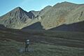
Looking into the deep Eagle's Nest corrie from the Hag's Glen.
-
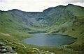
The Coomloughra Horseshoe around the Lough Coomloughra.
-
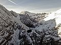
Carruntoohil's northeastern corrie (Eagle's Nest), a winter climbing area.
.jpg)
.jpg)
_in_Carrauntoohil_in_winter.jpg)
See also
 In Spanish: Macgillicuddy's Reeks para niños
