Mary Jane Thurston State Park facts for kids
Quick facts for kids Mary Jane Thurston State Park |
|
|---|---|

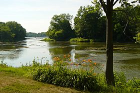
Maumee River at Mary Jane Thurston State Park
|
|
| Lua error in Module:Location_map at line 420: attempt to index field 'wikibase' (a nil value). | |
| Location | Wood & Henry counties, Ohio, United States |
| Area | 105 acres (42 ha) |
| Elevation | 643 feet (196 m) |
| Established | 1968 |
| Administered by | Ohio Department of Natural Resources |
| Designation | Ohio state park |
| Website | Mary Jane Thurston State Park |
Mary Jane Thurston State Park is a fun outdoor spot in Ohio, covering about 105 acres. It's located along the Maumee River, close to where the old Miami and Erie Canal used to be. This park is named after Mary Jane Thurston, a kind schoolteacher from Grand Rapids, Ohio, who gave her land to help start the park. You can visit the park all year round to enjoy activities like hunting, fishing, boating, picnicking, camping, and hiking.
Contents
History of the Park Area
Mary Jane Thurston State Park is found along the Maumee River near Grand Rapids, Ohio. This area has been very important throughout the history of northwest Ohio.
Native American Life
Long ago, rivers like the Maumee were like highways for many Indian tribes. These included the Iroquois, Miami, Lenape, Ottawa, Erie, Wyandot, and Shawnee. They used the rivers for travel, and also found plenty of water, fish, and animals to hunt.
Early American Settlement
Later, explorers from Europe and America also came to these rivers for the same reasons. President George Washington sent General Anthony Wayne and his army to the Northwest Territory. Their job was to stop an uprising by Native American tribes, led by the Shawnee leader Blue Jacket. General Wayne built Fort Defiance and won a big battle called the Battle of Fallen Timbers. After this, more American settlers moved into the land. They cleared the forests and started farms.
The Canal Era
The Miami and Erie Canal and the Wabash and Erie Canal once passed through what is now the park. These canals were like long, man-made rivers that connected the Ohio River with Lake Erie. Towns like Defiance grew along the canals, becoming busy places for trade and industry. The canal system was very important for about 30 years in the mid-1800s. However, railroads soon became popular and took over from the canals.
Building Grand Rapids
In the 1840s, it was hard to keep enough water in the canals. So, in 1845, Ohio built a large dam across the Maumee River at a place called Gilead. This new dam replaced a smaller one that powered a mill. The people of Gilead were very angry because the new dam stopped their mill from getting enough water. They were so upset that they destroyed the dam! After this, a special side canal was built to connect Gilead to the main canal. This helped Gilead's economy grow, and the village became known as Grand Rapids in 1855.
How the Park Began
The first 14 acres of Mary Jane Thurston State Park were given by the park's namesake, Mary Jane Thurston. She was a teacher in Grand Rapids. Ms. Thurston donated her land in 1928. Over the next 40 years, more land around her plot was bought. Finally, the park opened to the public in 1968.
Geography of the Maumee Valley
Mary Jane Thurston State Park is located in the Maumee Valley. This valley was once covered by a huge ancient lake called Lake Maumee. This lake was left over from the last ice age. Lake Maumee stretched from what is now Fort Wayne, Indiana, all the way to western New York state. Over time, the water from Lake Maumee shifted, creating Lake Erie and forming the Maumee Valley we see today.
The Great Black Swamp
The Maumee Valley changed a lot after settlers arrived. It used to be in the middle of a huge, wet area called the Great Black Swamp. This swamp was about 30 to 40 miles wide and 120 miles long. It was a very thick forest with giant sycamore trees. These trees were so big that people used them to build barns and even homes. Other trees like Oak and tulip trees also grew there. Sadly, almost every tree was cut down within 100 years of Ohio being settled.
Changing Landscapes
The Maumee Valley was one of the last parts of Ohio to be cleared. The swampy ground made it very difficult for settlers to move in. Between 1859 and 1875, the swamp was drained using many ditches and drains. After the swamps were emptied, nearly 2.5 million acres of land were cleared. By 1885, the region was mostly covered with farms, just like it is today. Now, only about six percent of the Maumee Valley is still covered with forests. Some of these remaining forest areas are found in Mary Jane Thurston State Park and along the Maumee River.
Recreation at the Park
Mary Jane Thurston State Park offers many fun activities for visitors.
Fun Activities at the Park
You can go camping and enjoy the outdoors. Boating on the Maumee River is a popular activity. The park also has places for picnicking, where you can have a meal with family and friends. If you like wildlife, you can go hunting for common animals like white-tailed deer and wild turkeys. Fishing is also popular, and you might catch northern pike, bullhead catfish, smallmouth bass, or crappie. A one-mile part of the Buckeye Trail also runs through the park, perfect for hiking.
 | Aurelia Browder |
 | Nannie Helen Burroughs |
 | Michelle Alexander |

