Monte Burney facts for kids
Monte Burney is a volcano in southern Chile. It is part of the Austral Volcanic Zone, which has six volcanoes that have been active in the last 2.6 million years (the Quaternary period). This volcanic activity happens because the Antarctic Plate is slowly sliding under the South America Plate and the Scotia Plate. This process is called subduction.
Monte Burney has a large caldera (a bowl-shaped hollow formed after an eruption). On its edge, there is a stratovolcano (a cone-shaped volcano) covered in ice. This stratovolcano also has a smaller caldera at its top. People reported an eruption in 1910, and there are less certain reports of eruptions in 1970 and 1920.
Scientists have studied tephra (ash and rock fragments from eruptions) from Monte Burney. They found signs of many eruptions during the Pleistocene and Holocene periods. This includes two very large explosive eruptions that happened early and in the middle of the Holocene. These eruptions left thick layers of ash and rock over Patagonia and Tierra del Fuego.
Contents
What's in a Name?
The volcano is named after James Burney. He was a friend of the famous explorer James Cook. Many places in this region have English names. This is because many English research trips explored the area. Famous explorers like Robert FitzRoy and Phillip Parker King visited between 1825 and 1830.
Where is Monte Burney Located?
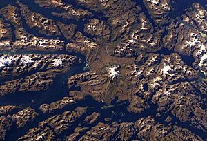
Monte Burney is found on the northwest part of the Muñoz Gomera Peninsula in Chile. This area is part of the Patagonian region, which is famous for its amazing fjords (long, narrow sea inlets). The volcano is in the commune of Natales. It is about 200 kilometers (124 miles) northwest of Punta Arenas and about 100 kilometers (62 miles) southwest of Puerto Natales. This area is very remote and has no people living there. The first time anyone climbed Monte Burney was in March 1973. The climbers were Eric Shipton, Roger Perry, and Peter Radcliffe.
Volcanoes in the Andes
The Andes Mountains have four main areas where volcanoes are active. These are the Northern, Central, Southern, and Austral Volcanic Zones. Sometimes, volcanoes also appear behind the main volcanic line, up to 250 kilometers (155 miles) away. These volcanic zones are separated by gaps where there are no active volcanoes.
The Southern and Austral Volcanic Zones have about 74 volcanoes that have been active since the last ice age. These include different types of volcanoes, like single-eruption volcanoes (monogenetic), cone-shaped stratovolcanoes, and complex groups of volcanoes. Llaima and Villarrica are two of the most active volcanoes in this region. A gap without volcanoes separates the Southern and Austral zones, near the Chile Triple Junction.
The biggest volcanic eruption in this region happened about 7,750 years ago at Cerro Hudson volcano. Its ash covered all of southern Patagonia and Tierra del Fuego. This huge eruption likely caused many people to leave Tierra del Fuego. It also temporarily stopped the trade of obsidian (a type of volcanic glass) and changed how people lived in the area.
Monte Burney's Features
Monte Burney is the southernmost stratovolcano in the Austral Volcanic Zone. Six volcanoes make up this 800-kilometer (497-mile) long chain. The Antarctic Plate slides under the South America Plate and the Scotia Plate at about 2 centimeters (0.8 inches) per year. This slow movement causes the volcanoes to form. The rocks from these volcanoes have a special chemical makeup because the part of the Earth's crust sliding underneath is quite young (12-24 million years old).
Monte Burney has a large caldera that is about 6 kilometers (3.7 miles) wide. This caldera is partly filled with rock and ash from fast-moving volcanic flows called pyroclastic flows. Some of these flows even spread outside the caldera. On the western edge of this caldera, the 1,758-meter (5,768-foot) high Monte Burney volcano grew. It's not a simple cone; it has its own caldera at the top with jagged peaks.
This volcano is covered by a glacier (a large mass of ice) that stretches between 688 and 1,123 meters (2,257 and 3,684 feet) in height. The glacier holds about 0.4 cubic kilometers (0.1 cubic miles) of ice. The volcano also shows signs of a "sector collapse," where a large part of its side slid away. There are also smaller vents on its sides, called flank vents. These vents have produced lava and pyroclastic flows. The edge of the larger caldera is surrounded by a ring of lava domes (mound-shaped formations of thick lava).
What is Monte Burney Made Of?
The flank vents of Monte Burney have erupted andesite and dacite. These are types of volcanic rocks. Scientists have found minerals like amphibole, plagioclase, and pyroxene in the rocks. They also found other materials like olivine crystals and pieces of granite from the Patagonian batholith (a large mass of igneous rock).
Monte Burney also has special rocks called adakitic rocks. These rocks suggest that the magma (molten rock) came from the relatively hot and young Antarctic Plate as it slid underneath. As this magma moved up, it changed a bit because of the pressure from the Earth's plates.
Climate Around Monte Burney
The weather in the Patagonian region is affected by its closeness to Antarctica and by strong westerly winds in the Southern Hemisphere. Cold air from the poles, cool ocean currents (called upwelling), and rain caused by mountains (orographic precipitation) also shape the climate.
During the Pleistocene, there were at least four periods when glaciers covered the area. Monte Burney was covered by ice during the last glacial maximum (the coldest part of the last ice age). In the early Holocene, glaciers melted quickly, then slowed down. There was a small increase in glacier size during the Little Ice Age.
Monte Burney's Eruptions
Monte Burney has erupted many times throughout history. During the Pleistocene, two eruptions about 49,000 and 48,000 years ago left ash in Laguna Potrok Aike. This lake is about 300 kilometers (186 miles) east of the volcano. Other eruptions happened around 26,200 and 31,000 years ago. Ash from Monte Burney's Holocene eruptions has also been found in this lake. This suggests Monte Burney might be the most active volcano in the region during the late Quaternary period.
Scientists use Radiocarbon dating and tephrochronology (dating using ash layers) to study past eruptions. Two very large eruptions, called Plinian eruptions, happened around 7,450 BCE and 2,320 BCE. These eruptions were so powerful they had a volcanic explosivity index (VEI) of 5. They created the MB1 and MB2 ash layers. The MB2 eruption might have created the summit caldera (the bowl-shaped top) of the volcano. Its ash layers were over 5 meters (16 feet) thick east of the volcano. This ash might have even reached Antarctica!
These large eruptions likely affected the people living in the region long ago. They might have caused people to move to areas with more reliable resources. The ash from the MB2 eruption also caused the soil to become acidic for thousands of years. This led to the decay of Nothofagus trees in the area. Ash from these eruptions has been found in many places, including Lake Arturo in Argentina, coastal areas of Tierra del Fuego, and even the Falklands Islands, about 950 kilometers (590 miles) away!
Other eruptions happened at different times, including around 90, 800, 3,740, and 7,390 BCE. Some of these eruptions left traces in cave deposits south of Monte Burney. Ash from an eruption about 2,000 years ago was 12 centimeters (4.7 inches) thick in a peat bog 70 kilometers (43 miles) away.
Only one eruption has been recorded in recent history, which happened in 1910. This eruption had a VEI of 2 and was seen by a merchant ship. It seemed to happen at the same time as an earthquake and tsunami on June 24, 1910. There are also unconfirmed reports of an eruption in 1920, and reports of a flash of light and earthquakes on June 24, 1970. However, local newspapers from that time did not mention these events. Even today, small seismic (earthquake) activity happens at Monte Burney.
Studying Monte Burney
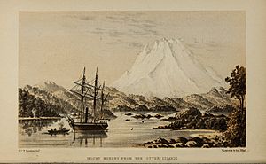
People knew about Monte Burney even before 1871. A book from that year by Robert Oliver Cunningham described the mountain:
the entire mass of a magnificent solitary mountain a little to the northward, in general shrouded more or less in mist, and the summit of which we had never seen, was revealed, without a cloud to dim the dazzling splendour of its jagged snowy peaks, the extensive snow-fields which clothed its sides and the deep blue crevassed glaciers which filled its gorges.
In 1899, the mountain was called "majestic." Eric Shipton explored the area in 1962. After trying again in 1963, he finally climbed Monte Burney on March 10, 1973, with Peter Radcliffe and Roger Perry. In 2015, the Chilean geological agency SERNAGEOMIN started setting up equipment to monitor Monte Burney. It was the first volcano in the Magallanes Patagonia region to be watched closely.
See also
 In Spanish: Monte Burney para niños
 | Frances Mary Albrier |
 | Whitney Young |
 | Muhammad Ali |


