Montpelier, Indiana facts for kids
Quick facts for kids
Montpelier, Indiana
|
|||
|---|---|---|---|
Montpelier, Indiana
|
|||
|
|||
| Nickname(s):
Oil City
|
|||
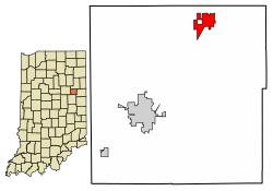
Location of Montpelier in Blackford County, Indiana.
|
|||
| Country | United States | ||
| State | Indiana | ||
| County | Blackford | ||
| Township | Harrison | ||
| Settled | 1836 | ||
| Incorporated (town) | 1870 | ||
| Incorporated (city) | 1895 | ||
| Area | |||
| • Total | 1.50 sq mi (3.87 km2) | ||
| • Land | 1.50 sq mi (3.87 km2) | ||
| • Water | 0.00 sq mi (0.00 km2) 0% | ||
| Elevation | 879 ft (268 m) | ||
| Population
(2020)
|
|||
| • Total | 1,540 | ||
| • Density | 1,029.41/sq mi (397.57/km2) | ||
| Time zone | UTC-5 (EST) | ||
| • Summer (DST) | UTC-4 (EDT) | ||
| ZIP code |
47359
|
||
| Area code(s) | 765 | ||
| FIPS code | 18-50796 | ||
| GNIS feature ID | 2395388 | ||
| Website | http://montpelier-indiana.com/ | ||
Montpelier is a city in Blackford County, Indiana, located in Harrison Township. This small community was settled by people from Vermont. They named it after Vermont's capital city, Montpelier, Vermont.
Montpelier was very important during the Indiana Gas Boom. Natural gas was found nearby in 1887. Even more importantly, the first successful oil well in the county was drilled here in 1890. Because of this, Montpelier's population grew quickly. It went from 808 people in 1890 to about 6,500 by 1896! The Gas Boom, which was mostly an oil boom for Montpelier, slowed down in the early 1900s.
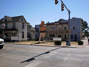
Like many boom towns, Montpelier's population is not as high as it was during the boom years. In 2010, about 1,805 people lived here. However, the city's population has been stable for many years. Today, Montpelier has several businesses and an active community. A statue of an Indian chief stands in the downtown area. It reminds people of the nearby Godfroy Indian Reservation.
Contents
History of Montpelier
How Montpelier Was Settled
In 1836 and 1837, groups of settlers from Vermont moved to East Central Indiana. They settled on high ground near the Salamonie River. Abel Baldwin, a veteran of the War of 1812, led these Vermont settlers. They named their new home Montpelier, just like the capital of their home state. Baldwin and his son-in-law, John Cook, surveyed the land in 1836. The town was officially planned on September 5, 1837. It started with 16 blocks and 154 lots.
When Montpelier was first settled, it was part of Jay County, Indiana. In 1838, the western part of Jay County became Blackford County, Indiana. Montpelier was not the very first community in what would become Blackford County. A village called Matamoras, Indiana existed earlier. However, Montpelier was planned first, and Matamoras became a ghost town after the 1880s.
In September 1870, a railroad connected Fort Wayne, Indiana with Muncie, Indiana. Montpelier was on this important train line. With better transportation, Montpelier officially became a town at the end of 1870. By then, its population had grown to 231 people.
The Exciting Gas Boom Years
In 1887, natural gas was found in Blackford County. This started the Indiana Gas Boom in the area. While natural gas was found all over Blackford County, crude oil was mostly found in Montpelier's Harrison Township. The first successful oil well in Blackford County started producing oil in 1890, just south of Montpelier.
People believed Montpelier was "the very heart of the greatest natural gas and oil field in the world." By the mid-1890s, about two-thirds of Harrison Township was an oil-producing area. Montpelier became a very busy city. Oil production from the Trenton Gas and Oil Field around Montpelier began to slow down in the early 1900s. The Gas Boom, or Montpelier's oil boom, gradually ended. Montpelier returned to normal, and its population has never reached its Gas Boom peak again.
A Famous Bank Event
The Montpelier National Bank was involved in a famous event on August 4, 1933. Three men entered the bank in the afternoon. The event lasted about ten minutes, and no one was hurt. The men quietly left town, driving east. Later, the Federal Bureau of Investigation (FBI) determined that the people involved were John Dillinger and his group.
Montpelier's Geography and Climate
Where is Montpelier Located?
Montpelier is in East Central Indiana and Northern Indiana. Millions of years ago, two glaciers flattened this area. These glaciers also created the rich farmland around Montpelier.
The city is located in Harrison Township, Blackford County, Indiana, right next to the Salamonie River. Montpelier is about 40 miles (64 km) south of Fort Wayne, Indiana. It is also about 75 miles (121 km) northeast of Indianapolis, Indiana.
According to the 2010 census, Montpelier covers an area of 1.54 square miles (3.99 sq km). All of this area is land.
Cities Close to Montpelier
- Bluffton, Indiana (about 20 miles north)
- Hartford City, Indiana (about 12 miles southwest)
- Marion, Indiana (about 20 miles west)
- Portland, Indiana (about 24 miles southeast)
- Upland, Indiana (about 18 miles southwest)
- Dunkirk, Indiana (about 15 miles southeast)
Montpelier's Weather Patterns
Montpelier has a typical Midwestern humid continental climate. This means it has four clear seasons. Winters are cold with some snow. Summers can be hot and humid.
The warmest average temperature is in July, at 84 °F (29 °C). The coldest average temperature is in January, at 18 °F (−8 °C). However, summer temperatures can go above 90 °F (32 °C). Winter temperatures can drop below 0 °F (−17 °C). On average, Montpelier gets about 2 to 4 inches (5 to 10 cm) of rain each month. The most rain falls in June, July, and August.
| Climate data for Montpelier, Indiana | |||||||||||||
|---|---|---|---|---|---|---|---|---|---|---|---|---|---|
| Month | Jan | Feb | Mar | Apr | May | Jun | Jul | Aug | Sep | Oct | Nov | Dec | Year |
| Mean daily maximum °F (°C) | 33 (1) |
38 (3) |
49 (9) |
62 (17) |
72 (22) |
81 (27) |
84 (29) |
82 (28) |
76 (24) |
65 (18) |
50 (10) |
38 (3) |
61 (16) |
| Mean daily minimum °F (°C) | 18 (−8) |
22 (−6) |
31 (−1) |
41 (5) |
50 (10) |
60 (16) |
63 (17) |
62 (17) |
54 (12) |
43 (6) |
34 (1) |
23 (−5) |
42 (5) |
| Average precipitation inches (mm) | 1.96 (50) |
1.94 (49) |
2.79 (71) |
3.37 (86) |
3.81 (97) |
4.33 (110) |
4.28 (109) |
4.05 (103) |
2.88 (73) |
2.48 (63) |
3.37 (86) |
2.70 (69) |
37.96 (966) |
| Source: The Weather Channel | |||||||||||||
Montpelier's Population and People
| Historical population | |||
|---|---|---|---|
| Census | Pop. | %± | |
| 1870 | 231 | — | |
| 1880 | 618 | 167.5% | |
| 1890 | 808 | 30.7% | |
| 1900 | 3,405 | 321.4% | |
| 1910 | 2,786 | −18.2% | |
| 1920 | 2,297 | −17.6% | |
| 1930 | 1,859 | −19.1% | |
| 1940 | 1,800 | −3.2% | |
| 1950 | 1,826 | 1.4% | |
| 1960 | 1,954 | 7.0% | |
| 1970 | 2,093 | 7.1% | |
| 1980 | 1,995 | −4.7% | |
| 1990 | 1,880 | −5.8% | |
| 2000 | 1,929 | 2.6% | |
| 2010 | 1,805 | −6.4% | |
| 2020 | 1,540 | −14.7% | |
| U.S. Decennial Census | |||
The table shows Montpelier's highest population was 3,405 in 1900. However, it is believed that over 6,500 people lived in the city around 1896. This was during the peak of the Indiana Gas Boom.
What the 2010 Census Showed
In 2010, the census counted 1,805 people living in Montpelier. There were 708 households and 470 families. The city had about 1,172 people per square mile (452 per sq km).
Most residents (97.9%) were White. A small number were African American (0.3%), Native American (0.3%), or Asian (0.1%). About 0.9% of the population was Hispanic or Latino.
About 36.7% of households had children under 18. Many households (45.3%) were married couples living together. The average household had 2.55 people, and the average family had 3.10 people.
The average age in Montpelier was 36.3 years. About 28.1% of residents were under 18. About 13.1% were 65 years or older. The population was almost evenly split between males (50.1%) and females (49.9%).
Montpelier's Economy and Jobs
Montpelier is in a farming area and has its own grain elevator. The city also has some factories. Its main businesses provide jobs for over 400 people. These companies include Emhart-Gripco, Smith Consulting, Indiana Veneer, BRC Rubber & Plastics, and Indiana Box. Montpelier also has a 50-acre industrial park for businesses.
Culture and Community Life
Montpelier has a long history with racing. In the 1800s, there were at least two horse race tracks nearby. Montpelier's own horse track opened in 1903. It was very popular, drawing crowds of 3,000 people. In the 1920s, a rebuilt track became known as the fastest half-mile track in Indiana.
In the 1950s, the track was used for stock car racing. It went back to horse racing in the 1960s. The track closed in 1973 but reopened in 1985 for both stock car and horse races. Today, Montpelier Raceway hosts sanctioned stock car racing events.
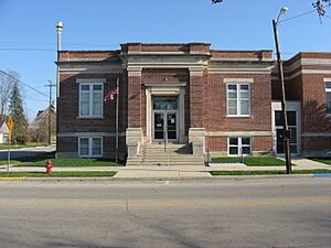
The Public Library of Montpelier and Harrison Township was built in 1907 and 1908. The building was possible because of a $10,000 gift from Andrew Carnegie, a famous businessman and giver. This building is in the Classical Revival style. It was added to the National Register of Historic Places in 2007. It is one of only three individual buildings in Blackford County listed on the National Register.
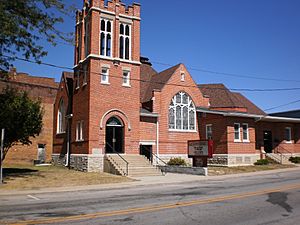
Montpelier's First Baptist Church was started by Franklin Baldwin in 1838. He was the brother of Abel Baldwin, who led Montpelier's first settlers. The current church building, in downtown Montpelier, was built in 1907 and 1908. It has been updated since then.
High school basketball is very popular in Indiana, and Montpelier has a strong history in the sport. Even though it's a smaller school, Montpelier High School won five sectional basketball championships. After schools combined, Montpelier students started going to Blackford High School. Blackford High School has won ten sectional championships. Other sports in Montpelier include Little League baseball, Tee Ball, and softball. You can also find golfing, camping, and fishing nearby.
The Montpelier Jamboree is a yearly celebration that started in 1945. This event happens on Labor Day weekend. It features music, a Jamboree Queen contest, and other fun activities.
The Miami Indians' Connection to Montpelier
The former Godfroy Reservation was an Indian reservation for Chief Francis Godfroy and Miami Indians. It was located near Montpelier, on the Salamonie River, from 1827 to 1836. Francis was the English way to say Godfroy's real name, François. The Miami Indians called him Palonzwa. Chief Godfroy's father was French, and his mother was from the Miami tribe. He was a big man, six feet tall and 300 pounds. Godfroy was the last war chief of the Miami Nation.
A sculpture of a Plains Indian stands in downtown Montpelier. It was given by Chief Larry Godfroy. This sculpture was even shown in the opening of the TV show Parks and Recreation. The "Ice Cream Giant" at the old Point Restaurant north of Montpelier was also in that TV clip.
Montpelier's Infrastructure
Montpelier used to have its own elementary school, which closed in 2022. High school students now attend the county's Blackford High School. Five universities, including Ball State University and Taylor University, are located within 30 miles (48 km) of Montpelier.
The Norfolk Southern Railway provides freight train service. It connects Montpelier to Fort Wayne and Indianapolis. This railroad was very important for Montpelier's growth during the Gas Boom. It was known as the Lake Erie and Western Railroad in the 1890s. Indiana Highway 18 runs through Montpelier. Interstate 69 is 14 miles (23 km) west of the city. The closest airport with commercial flights is in Fort Wayne, about 40 miles (64 km) north.
Main Roads Near Montpelier
Notable People From Montpelier
- Annetta R. Chipp, a leader in the temperance movement and a prison evangelist.
- Kevin A. Ford, a NASA astronaut.
- Lloyd Harris, an Illinois state representative.
See also
 In Spanish: Montpelier (Indiana) para niños
 | Kyle Baker |
 | Joseph Yoakum |
 | Laura Wheeler Waring |
 | Henry Ossawa Tanner |


