Morro Bay, California facts for kids
Quick facts for kids
Morro Bay
|
|||
|---|---|---|---|
| City of Morro Bay | |||
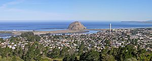
Aerial view of Morro Bay and Morro Rock
|
|||
|
|||

Location in San Luis Obispo County and the state of California
|
|||
| Country | United States | ||
| State | California | ||
| County | San Luis Obispo | ||
| Founded | 1870 | ||
| Incorporated | July 17, 1964 | ||
| Named for | Morro Rock | ||
| Government | |||
| • Type | Council–manager | ||
| • Body | Morro Bay City Council | ||
| Area | |||
| • Total | 10.32 sq mi (26.74 km2) | ||
| • Land | 5.33 sq mi (13.80 km2) | ||
| • Water | 5.00 sq mi (12.94 km2) 48.63% | ||
| Elevation | 62 ft (19 m) | ||
| Population
(2020)
|
|||
| • Total | 10,757 | ||
| • Density | 1,042.3/sq mi (402.28/km2) | ||
| Time zone | UTC−08:00 (Pacific Standard Time) | ||
| • Summer (DST) | UTC−07:00 (Pacific Daylight Time) | ||
| ZIP codes |
93442–93443
|
||
| Area code | 805 | ||
| FIPS code | 06-49362 | ||
| GNIS feature ID | 1661062 | ||
Morro Bay is a pretty seaside city in San Luis Obispo County, California. The word Morro means "Hill" in Spanish. This city is located on the Central Coast of California. In 2020, about 10,757 people lived there. The city sits next to Morro Bay, which is a natural bay. This bay has a harbor for both fishing boats and fun recreational boats.
Contents
History of Morro Bay
Early Days and Explorers
Long ago, the Chumash people lived in the Morro Bay area. They had a settlement near the mouth of Morro Creek. They even had a name for a tribal site, tsɨtqawɨ, which meant "Place of the Dogs."
The first Europeans to explore this part of California were from Spain. The Portolá expedition camped near Morro Bay on September 8, 1769. A member of the expedition, Juan Crespí, wrote in his diary about seeing a "great rock in the form of a round morro." This is how Morro Rock got its name.
The first recorded Filipinos to visit America arrived here on October 18, 1587. They came on a Spanish ship called Nuestra Señora de la Esperanza.
Founding the Town
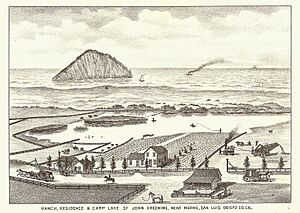
When Mexico governed the area, large land grants created cattle and dairy ranches. These ranches needed a way to ship their goods.
Franklin Riley founded the town of Morro Bay in 1870. He wanted it to be a port for sending out dairy and farm products. He helped build a wharf, which is now called the Embarcadero. In the 1870s, ships called schooners would pick up wool, potatoes, and other farm goods.
A special type of butterfly, the "Morro Bay Blue," was first found here in 1929.
Morro Bay During World War II
During World War II, the U.S. Navy had a base in Morro Bay. It was on the north side of Morro Rock. Sailors trained there to use landing craft. These boats were used to land troops on beaches.
A large wall, called a breakwater, was built in 1944–45. It helped protect the boats entering and leaving the harbor. Many soldiers who trained here later went to Normandy on D-Day.
Fishing and Industry
In the 1940s, Morro Bay became known for abalone fishing. This industry grew until 1957. However, too much fishing caused the abalone numbers to drop. Today, people still catch fish like Halibut, sole, and rockfish. Oysters are also grown in the shallow parts of the bay.
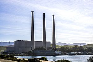
The Pacific Gas and Electric Company built the Morro Bay Power Plant in the early 1950s. This plant created many jobs and helped the city's economy. Morro Bay officially became a city in 1964. The power plant closed in 2014.
Geography of Morro Bay
Morro Bay is the name of a large estuary (where a river meets the sea). This estuary is along the northern shores of a bigger bay called Estero Bay. Other towns like Cayucos and Los Osos are also in Estero Bay.
The city of Morro Bay is about 20 kilometers (12 miles) northwest of San Luis Obispo. It is located right on Highway 1. A creek called Los Osos Creek flows into Morro Bay.
The city covers about 26.74 square kilometers (10.3 square miles). About half of this area is land, and the other half is water.
Morro Rock: A Famous Landmark
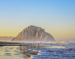
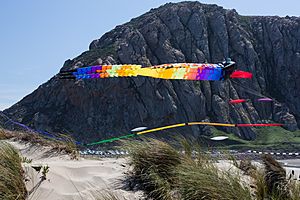
Morro Rock is a huge rock that stands 576 feet (176 meters) tall. It is a volcanic plug, which means it's the leftover core of an ancient volcano. This rock is at the entrance to the harbor. The word morro describes a distinct, prominent hill-shaped rock.
Long ago, water surrounded Morro Rock. But a channel was filled in to create the harbor. People used to quarry (mine) rock from Morro Rock until 1969. In 1968, it became a Historical Landmark.
You can visit the area around the base of Morro Rock. There are parking lots and paths for walking. However, climbing the rock is not allowed. This is because it can be dangerous. Also, it is a special place where peregrine falcons live.
Morro Rock is part of a group of similar rocks called the Nine Sisters. These rocks stretch in a line inland from the coast.
Morro Bay Harbor: A Safe Haven
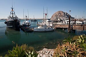
Morro Bay has a natural bay, but its harbor was built by the U.S. Army Corps of Engineers. It is the only harbor for small boats that can be used in all kinds of weather. This is true for the area between Santa Barbara and Monterey.
The Army built a large breakwater and a road. This connected Morro Rock to the mainland. Some of the rock for this was taken from Morro Rock itself. Other rock was brought in by boat from Catalina Island.
The bay stretches inland for about 6.4 kilometers (4 miles) south of Morro Rock. Morro Bay is protected by the California Bays and Estuaries Policy.
You can often see a small group of otters in the kelp near the harbor entrance during summer.
Climate: Always Mild
Morro Bay has a mild warm-summer Mediterranean climate. This means it has dry, warm summers and wet, mild winters. The Pacific Ocean helps keep the temperatures moderate all year. This makes winters warmer and summers cooler than places further inland.
In July, the average temperature is around 16°C (60°F). In January, the average is about 13°C (55°F). It usually rains about 8 days in January.
| Climate data for Morro Bay, CA (1991–2020 normals, extremes 1959–present) | |||||||||||||
|---|---|---|---|---|---|---|---|---|---|---|---|---|---|
| Month | Jan | Feb | Mar | Apr | May | Jun | Jul | Aug | Sep | Oct | Nov | Dec | Year |
| Record high °F (°C) | 89 (32) |
87 (31) |
92 (33) |
100 (38) |
98 (37) |
86 (30) |
92 (33) |
94 (34) |
101 (38) |
106 (41) |
92 (33) |
81 (27) |
106 (41) |
| Mean maximum °F (°C) | 74.9 (23.8) |
76.0 (24.4) |
78.4 (25.8) |
81.5 (27.5) |
78.8 (26.0) |
72.7 (22.6) |
76.4 (24.7) |
79.0 (26.1) |
83.4 (28.6) |
89.4 (31.9) |
80.1 (26.7) |
72.8 (22.7) |
91.7 (33.2) |
| Mean daily maximum °F (°C) | 65.1 (18.4) |
65.4 (18.6) |
66.0 (18.9) |
67.3 (19.6) |
66.9 (19.4) |
66.4 (19.1) |
67.2 (19.6) |
69.7 (20.9) |
71.5 (21.9) |
72.5 (22.5) |
69.1 (20.6) |
64.6 (18.1) |
67.6 (19.8) |
| Daily mean °F (°C) | 55.7 (13.2) |
56.6 (13.7) |
57.3 (14.1) |
58.3 (14.6) |
59.3 (15.2) |
60.0 (15.6) |
61.8 (16.6) |
63.2 (17.3) |
63.7 (17.6) |
63.5 (17.5) |
59.7 (15.4) |
55.4 (13.0) |
59.5 (15.3) |
| Mean daily minimum °F (°C) | 46.4 (8.0) |
47.8 (8.8) |
48.6 (9.2) |
49.2 (9.6) |
51.7 (10.9) |
53.6 (12.0) |
56.5 (13.6) |
56.8 (13.8) |
56.0 (13.3) |
54.4 (12.4) |
50.2 (10.1) |
46.2 (7.9) |
51.5 (10.8) |
| Mean minimum °F (°C) | 36.2 (2.3) |
36.3 (2.4) |
38.7 (3.7) |
39.2 (4.0) |
43.1 (6.2) |
45.6 (7.6) |
50.0 (10.0) |
49.9 (9.9) |
48.2 (9.0) |
44.6 (7.0) |
39.1 (3.9) |
34.9 (1.6) |
32.6 (0.3) |
| Record low °F (°C) | 23 (−5) |
22 (−6) |
28 (−2) |
31 (−1) |
33 (1) |
39 (4) |
40 (4) |
40 (4) |
41 (5) |
36 (2) |
31 (−1) |
22 (−6) |
22 (−6) |
| Average precipitation inches (mm) | 3.64 (92) |
3.62 (92) |
3.19 (81) |
0.99 (25) |
0.42 (11) |
0.20 (5.1) |
0.07 (1.8) |
0.02 (0.51) |
0.09 (2.3) |
0.68 (17) |
1.33 (34) |
2.75 (70) |
17.00 (432) |
| Average precipitation days (≥ 0.01 in) | 7.0 | 8.2 | 7.0 | 4.1 | 1.8 | 0.4 | 0.4 | 0.3 | 0.7 | 2.1 | 3.4 | 6.9 | 42.3 |
| Source: NOAA | |||||||||||||
People of Morro Bay
| Historical population | |||
|---|---|---|---|
| Census | Pop. | %± | |
| 1950 | 1,659 | — | |
| 1960 | 3,692 | 122.5% | |
| 1970 | 7,109 | 92.6% | |
| 1980 | 9,064 | 27.5% | |
| 1990 | 9,664 | 6.6% | |
| 2000 | 10,350 | 7.1% | |
| 2010 | 10,234 | −1.1% | |
| 2020 | 10,757 | 5.1% | |
| U.S. Decennial Census | |||
Population in 2010
In 2010, Morro Bay had a population of 10,234 people. Most residents (87.1%) were White. About 14.9% of the population was Hispanic or Latino.
Most people lived in homes, not in group housing. There were 4,844 households in total. About 19% of these households had children under 18. The average household had about 2 people.
The population was spread out by age. About 15% were under 18. About 23.7% were 65 years or older. The average age in Morro Bay was 48.9 years.
More than half of the homes (53.3%) were owned by the people living in them. The rest were rented.
Population in 2000
In 2000, Morro Bay had 10,350 people. There were 4,986 households. About 16.7% of households had children under 18. The average household size was 2.04 people.
The average age was 46 years. About 15.1% of the population was under 18. About 24.2% were 65 years or older.
The average income for a household was $34,379. For families, it was $43,508. About 13% of the people lived below the poverty line. This included 16.9% of those under 18.
Morro Bay has schools for kids. Morro Bay High School serves grades 9-12. Del Mar Elementary offers education for grades K-5.
Economy and Tourism
Tourism is the biggest industry in Morro Bay. Many visitors come to enjoy the city. The commercial fishing industry is also important.
Along the shoreline, especially on the Embarcadero, you'll find many things for tourists. There are restaurants, shops, and parks. The city relies a lot on visitors staying in hotels. The taxes from these stays help fund the city's services. Hotels, motels, and inns in Morro Bay often update their facilities to welcome guests.
The most popular beach is north of Morro Rock, by the harbor. There are also great beaches north and south of town. These include Morro Strand State Beach and Morro Bay State Park.
The Power Plant's Role
The power plant in Morro Bay was very important. It provided electricity to the Central Coast and the Central Valley. The plant was built in the 1950s. It employed 44 people. Taxes from the natural gas it burned helped the city's budget.
The plant closed in February 2014. It needed expensive upgrades to keep running.
In 2018, companies started planning to use the power plant's connection to the electricity grid. They want to connect a large offshore wind park. This park would have up to 100 floating wind turbines. These turbines would be about 30 miles off the coast.
In 2021, the city council decided to take down the power plant's tall smoke stacks by 2028. It costs about a million dollars a year to maintain them. The company Vistra Corp agreed to remove the stacks. They plan to build a large lithium-ion battery storage facility there.
Notable People from Morro Bay
- James Horvath, a children's author and illustrator.
- Jack LaLanne, a famous American fitness and nutrition expert.
- Jerome Long, an NFL defensive lineman.
- Kent Nagano, a conductor and opera administrator who grew up here. He graduated from Morro Bay High School.
- Mel Queen, a professional baseball player and coach.
- Gladys Walton, a silent film actress.
See also
 In Spanish: Morro Bay para niños
 | Janet Taylor Pickett |
 | Synthia Saint James |
 | Howardena Pindell |
 | Faith Ringgold |


