
San Luis Obispo, California facts for kids
Quick facts for kids
San Luis Obispo
|
|||
|---|---|---|---|
.jpg)   _(cropped).jpg) .jpg) Clockwise from top: Mission San Luis Obispo de Tolosa, Downtown San Luis, California Polytechnic State University, Mission San Luis Obispo de Tolosa, Higuera Street.
|
|||
|
|||
| Nickname(s):
"SLO", "San Luis", "SLO Town", "SLOcal"
|
|||

Location in San Luis Obispo County and the state of California
|
|||

San Luis Obispo
Location in the United States
|
|||
| Country | United States | ||
| State | California | ||
| County | San Luis Obispo | ||
| Founded | September 1, 1772 | ||
| Incorporated | February 16, 1856 | ||
| Named for | St. Louis of Toulouse | ||
| Government | |||
| • Type | Mayor–council | ||
| • Body | San Luis Obispo City Council | ||
| Area | |||
| • Total | 13.45 sq mi (34.84 km2) | ||
| • Land | 13.31 sq mi (34.46 km2) | ||
| • Water | 0.15 sq mi (0.38 km2) 1.09% | ||
| Elevation | 233 ft (71 m) | ||
| Population
(2020)
|
|||
| • Total | 47,063 | ||
| • Density | 3,537/sq mi (1,366/km2) | ||
| Demonym(s) | San Luis Obispan | ||
| Time zone | UTC−8 (Pacific) | ||
| • Summer (DST) | UTC−7 (PDT) | ||
| ZIP Codes |
93401–93403, 93405–93410, 93412
|
||
| Area code | 805 | ||
| FIPS code | 06-68154 | ||
| GNIS feature IDs | 1652788, 2411796 | ||
| Congressional district | 24th | ||


San Luis Obispo (Spanish for 'St. Louis the Bishop'; /sæn ˌluː[unsupported input] əˈbɪspoʊ/ san-_-loo-ISS-_-Ə-biss; Spanish: [san ˈlwis oˈβispo]; Chumash: tiłhini) is a city in San Luis Obispo County, California, United States. It is the main city of the county. Located on the Central Coast of California, San Luis Obispo is about halfway between the San Francisco Bay Area and Greater Los Angeles. In 2020, the city had a population of 47,063 people.
San Luis Obispo was started by the Spanish in 1772. This happened when Saint Junípero Serra built Mission San Luis Obispo de Tolosa. The town grew steadily through the time when Mexico controlled the area. It then expanded quickly after California became part of the United States. San Luis Obispo is a popular place for tourists. It is known for its old buildings, vineyards, and friendly atmosphere. It is also home to California Polytechnic State University, San Luis Obispo.
Contents
History of San Luis Obispo
The first people to live in this area were the Chumash people. One of their oldest villages was south of San Luis Obispo. The Chumash used resources from the ocean along the Central Coast. They lived in many villages, including places like Los Osos and Morro Creek. The Chumash name for the area where San Luis Obispo is now was tiłhini (Obispeño for 'Place of the full moon').
Spanish Exploration and Founding (1769-1772)
.jpg)
In 1769, the Spanish Empire was expanding. Junípero Serra, a Franciscan priest, was ordered to bring the Catholic faith to Alta California. This was part of a plan to unite the empire under one religion and language. The first Spanish mission in Alta California was Mission San Diego de Alcalá, founded that same year.
On September 7, 1769, an expedition led by Gaspar de Portolá came into the San Luis Obispo area. They came from the coast near today's Pismo Beach. One of the people on the trip, Padre Juan Crespí, wrote about the area. Soldiers called it Cañada de Los Osos, which means "Valley of the Bears." The group traveled north along San Luis Obispo Creek. They then went west through Los Osos Valley and reached Morro Bay on September 9.
In 1770, Portola set up the Presidio of Monterey. Junípero Serra founded the second mission, Mission San Carlos Borromeo de Carmelo, in Monterey. This mission later moved to Carmel-by-the-Sea.
By 1772, people at the Presidio of Monterey and Mission San Carlos Borromeo de Carmelo were running out of food. Commander Pedro Fages led a hunting trip to "Bears Canyon" to find food. They sent over 25 mule loads of dried bear meat and seeds north. This helped the missionaries, soldiers, and baptized natives. After this, Junípero Serra decided that "Bears Canyon" would be a great place for the fifth mission.

The area had plenty of food and water. The weather was also very mild. The local Chumash were very friendly. Junípero Serra traveled from Carmel with soldiers and supplies. On September 1, 1772, he held the first Mass. A cross was put up near San Luis Creek. The next day, he left for San Diego. He left Father José Cavaller with the hard job of building the mission. Father José Cavaller, five soldiers, and two natives started building the Mission San Luis Obispo de Tolosa. This mission later became the town of San Luis Obispo. Both the mission and the town were named after Louis, a bishop from Toulouse, France. In Spanish, his name is "Luis, obispo de Tolosa."
Mexican Rule and Ranchos (1810-1846)
When Mexico fought for independence from Spain in 1810, California missions had to support themselves. They received little money or supplies from Spain. After Mexico won its independence in 1821, people wanted to remove the Spanish Franciscans. They also wanted to take control of the missions' lands. The new Mexican government had many problems. So, the missions were not actually taken over until the mid-1830s.
After 1834, the mission became a regular church. Most of its large land holdings were divided into land grants called ranchos. These ranchos were given out by the Mexican government from 1837 to 1846. The mission itself was granted in the last year. However, the main community stayed in the same place. This area became the center of today's city of San Luis Obispo.
American Development (1856-Present)
After California became part of the United States, San Luis Obispo was the first town to be officially formed in the new San Luis Obispo County. It is still the main city of the county today. Early in the American period, the area was known for being a bit wild. It was called "Barrio del Tigre" (Tiger-Town). This was because of many robberies and other problems. To make the area safer, a group of citizens formed a "vigilance committee." This group helped bring order to the community.
The ranchos continued to focus on raising cattle after California became a state. When gold was discovered, the price of beef went up. This helped the county's economy. However, a drought in 1863 ruined most ranchos. People then started focusing on other things. Many ranchos were broken up. The town's economy changed from cattle ranching to dairies, farming, and mining.
San Luis Obispo once had a busy Chinatown. This was near Palm Street and Chorro Street. Chinese workers were brought by Ah Louis to build the Pacific Coast Railway. They also built roads over the Cuesta Pass to Paso Robles and to Cambria. They also dug tunnels through Cuesta Ridge for the Southern Pacific Railroad from 1884 to 1894. Chinatown was centered around the Ah Louis Store and other businesses run by Chinese people. Today, only the Mee Heng Low chop suey shop remains. Some old items found from this time can be seen at the Palm Street parking garage. The San Luis Obispo Historical Society also has exhibits about the city's past.
San Luis Obispo was also a popular stop for people traveling to Los Angeles. U.S. Route 101 and California State Route 1 were built as more people started driving cars. Because it was a popular stop, the world's first motel, the Milestone Mo-Tel, was built here.
-
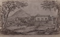
San Luis Obispo in 1864
-
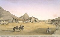
San Luis Obispo was known as the Barrio del Tigre (Spanish for 'Tiger Town') in the late 19th century, due to many robberies and other problems.
-
San Luis in the late 19th century

_1865.jpg)
.jpg)
Geography and Climate
.jpg)
San Luis Obispo is located on U.S. Route 101. It is about 31 miles (50 km) north of Santa Maria.
The city covers a total area of 13.45 square miles (34.84 km2). Most of this is land, with a small amount of water.
San Luis Obispo is on the West Coast of the United States. It is part of the Central Coast of California. The Pacific Ocean is about 11 miles (18 km) west of the city. The Santa Lucia Mountains are just east of San Luis Obispo. These mountains are where San Luis Obispo Creek begins. This creek flows to the Pacific Ocean at Avila Beach.
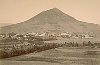
San Luis Obispo is in an area where earthquakes can happen. There are several nearby faults, including the San Andreas Fault. The Nine Sisters are a line of hills that run partly through San Luis Obispo. They are special because they are volcanic plugs. Six of these nine peaks are open for people to visit and enjoy.

San Luis Obispo Climate
San Luis Obispo has a warm Mediterranean climate. This means it has mild, wet winters and warm, dry summers. On average, it rains about 50 days a year, mostly in winter. Summers are usually warm and sunny, often with morning fog from the Pacific coast. Winters are generally mild. Temperatures can vary a lot throughout the year. For example, it can be 80°F (27°C) in January or February.
It has not officially snowed in San Luis Obispo since records began in 1870. However, photos show about 0.3 inches (0.8 cm) fell in 1922. Snow flurries were also reported in 1988 and 2006. The hottest temperature recorded was 113°F (45°C) on September 6, 2020. The cool ocean air keeps temperatures from getting too extreme. Nights stay cool all year. The average rainfall is about 22 inches (560 mm) per year. Most of this rain falls between November and April.
| Climate data for San Luis Obispo, California (CPSU), 1991–2020 normals, extremes 1927–present, precipitation 1893-2012 | |||||||||||||
|---|---|---|---|---|---|---|---|---|---|---|---|---|---|
| Month | Jan | Feb | Mar | Apr | May | Jun | Jul | Aug | Sep | Oct | Nov | Dec | Year |
| Record high °F (°C) | 90 (32) |
89 (32) |
92 (33) |
104 (40) |
102 (39) |
108 (42) |
111 (44) |
107 (42) |
113 (45) |
109 (43) |
98 (37) |
92 (33) |
113 (45) |
| Mean maximum °F (°C) | 78.3 (25.7) |
79.7 (26.5) |
82.5 (28.1) |
87.8 (31.0) |
89.1 (31.7) |
91.3 (32.9) |
90.9 (32.7) |
93.8 (34.3) |
97.9 (36.6) |
96.2 (35.7) |
86.8 (30.4) |
76.7 (24.8) |
102.0 (38.9) |
| Mean daily maximum °F (°C) | 64.9 (18.3) |
65.2 (18.4) |
67.3 (19.6) |
69.3 (20.7) |
71.9 (22.2) |
75.7 (24.3) |
78.3 (25.7) |
79.7 (26.5) |
80.1 (26.7) |
77.8 (25.4) |
70.8 (21.6) |
64.4 (18.0) |
72.1 (22.3) |
| Daily mean °F (°C) | 54.4 (12.4) |
54.8 (12.7) |
56.7 (13.7) |
58.0 (14.4) |
60.6 (15.9) |
63.8 (17.7) |
66.3 (19.1) |
67.3 (19.6) |
67.0 (19.4) |
64.7 (18.2) |
59.1 (15.1) |
54.0 (12.2) |
60.6 (15.9) |
| Mean daily minimum °F (°C) | 44.0 (6.7) |
44.4 (6.9) |
46.1 (7.8) |
46.8 (8.2) |
49.3 (9.6) |
51.8 (11.0) |
54.2 (12.3) |
54.8 (12.7) |
53.8 (12.1) |
51.5 (10.8) |
47.7 (8.7) |
43.7 (6.5) |
49.0 (9.4) |
| Mean minimum °F (°C) | 33.9 (1.1) |
34.5 (1.4) |
36.8 (2.7) |
38.3 (3.5) |
42.0 (5.6) |
45.3 (7.4) |
48.6 (9.2) |
49.5 (9.7) |
46.4 (8.0) |
41.6 (5.3) |
36.4 (2.4) |
33.2 (0.7) |
33.2 (0.7) |
| Record low °F (°C) | 24 (−4) |
21 (−6) |
28 (−2) |
29 (−2) |
32 (0) |
35 (2) |
36 (2) |
40 (4) |
35 (2) |
30 (−1) |
23 (−5) |
17 (−8) |
17 (−8) |
| Average precipitation inches (mm) | 4.96 (126) |
4.61 (117) |
3.37 (86) |
1.53 (39) |
0.43 (11) |
0.12 (3.0) |
0.02 (0.51) |
0.04 (1.0) |
0.25 (6.4) |
0.92 (23) |
2.14 (54) |
4.01 (102) |
22.4 (568.91) |
| Average precipitation days (≥ 0.01 in) | 8.7 | 9.8 | 8.6 | 4.1 | 2.4 | 0.7 | 0.5 | 0.2 | 0.7 | 3.2 | 4.4 | 8.4 | 51.7 |
| Source 1: NOAA | |||||||||||||
| Source 2: Western Regional Climate Center | |||||||||||||
Population and People
| Historical population | |||
|---|---|---|---|
| Census | Pop. | %± | |
| 1880 | 2,243 | — | |
| 1890 | 2,995 | 33.5% | |
| 1900 | 3,021 | 0.9% | |
| 1910 | 5,157 | 70.7% | |
| 1920 | 5,895 | 14.3% | |
| 1930 | 8,276 | 40.4% | |
| 1940 | 8,881 | 7.3% | |
| 1950 | 14,180 | 59.7% | |
| 1960 | 20,437 | 44.1% | |
| 1970 | 28,036 | 37.2% | |
| 1980 | 34,252 | 22.2% | |
| 1990 | 41,958 | 22.5% | |
| 2000 | 44,174 | 5.3% | |
| 2010 | 45,119 | 2.1% | |
| 2020 | 47,063 | 4.3% | |
| 2024 (est.) | 49,729 | 10.2% | |
| U.S. Decennial Census | |||
Population in 2020
The 2020 United States census showed that San Luis Obispo had 47,063 people. The population density was about 3,537 people per square mile (1,366 per km2). Most people (72.6%) were White. Other groups included African American (1.1%), Native American (0.7%), and Asian (6.2%). About 18.5% of the population was Hispanic or Latino.
Most people (97.0%) lived in homes. About 2.2% lived in group housing, like college dorms. There were 19,772 households. About 20.0% of these had children under 18. The average household had 2.31 people.
The age breakdown was: 14.6% under 18, 25.7% aged 18 to 24, 25.2% aged 25 to 44, 18.3% aged 45 to 64, and 16.2% aged 65 or older. The average age was 31.4 years.
In 2023, the average household income was $66,711. The income per person was $45,462. About 30.0% of the population was below the poverty line. This number includes many college students who may have low or no income.
Economy and Jobs
Downtown San Luis Obispo has many unique shops. Takken's Shoes has its main office here. Ernie Ball's Music Man factory is also in the city. Companies like Mindbody and iFixit started and are based in San Luis Obispo. In recent years, there has been a lot of new building for homes and businesses.
Pacific Gas and Electric is the largest non-government employer in the city. In 2016, they announced the Diablo Canyon Nuclear Power Plant would close in 2025. This was expected to cause a loss of 1,500 jobs. However, the plant's operating license was extended until 2030.
-
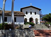
Mission San Luis Obispo de Tolosa, built in 1772, in downtown San Luis
-
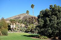
The Leaning Pine Arboretum
-
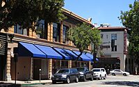
Shops at Higuera and Chorro streets in downtown San Luis
-
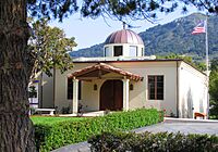
St. Anne Byzantine Catholic Church
-
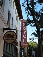
Historic Wineman Hotel
-
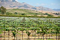
San Luis Obispo is a popular tourist spot as part of the Californian Central Coast wine region.
-
Mindbody Inc. headquarters
-
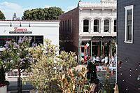
Restaurants in downtown San Luis
-
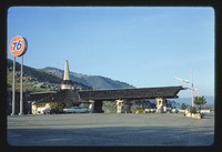
Union 76, San Luis Obispo, photographed by John Margolies in 1977
.JPG)

_(cropped).jpg)


.jpg)

.jpg)
Major Employers
Here are the top employers in San Luis Obispo, based on the city's 2021 financial report:
| # | Employer | Employees |
|---|---|---|
| 1 | California Polytechnic State University | 3,100 |
| 2 | County of San Luis Obispo | 2,920 |
| 3 | Dept. of State Hospitals - Atascadero | 2,140 |
| 4 | Pacific Gas and Electric (Diablo Canyon) | 1,950 |
| 5 | California Men's Colony | 1,500 |
| 6 | Tenet Healthcare | 1,305 |
| 7 | Compass Health | 1,200 |
| 8 | San Luis Coastal Unified School District | 1,200 |
| 9 | Dignity Health Central Coast | 1,000 |
| 10 | Lucia Mar Unified School District | 1,000 |
City Government and Services
.jpg)
San Luis Obispo is a charter city. This means it has its own local rules. It is also the main city for San Luis Obispo County. The city government has a "Council-Mayor-City Manager" system. The city council has five members. The mayor is elected for two-year terms. Four city council members are elected for four-year terms.
The San Luis Obispo fire department started in 1872. As of 2007, it has 45 full-time firefighters and four fire stations. The fire stations have teams that respond to emergencies. They respond to over 4,500 calls each year. The department also has a bike medic program for events like the Farmers' Market.
The city's Utilities Department provides safe drinking water. It started in 1872. The department operates a water treatment plant that can treat 16 million gallons a day. It also manages the Whale Rock Reservoir in Cayucos, CA. The Water Resource Recovery Facility treats 4.5 million gallons of water per day.
City Rules and Laws
.jpg)
.jpg)
In June 1990, San Luis Obispo became the first city in the world to ban smoking in all public indoor places. This included bars and restaurants. This rule has influenced similar laws around the world. In April 2010, the city made its anti-smoking laws even stronger. Smoking in public, with some exceptions, became a ticketable offense.
In 1982, the city council made a rule against building "drive-through" businesses. Because of this, a popular fast-food restaurant, In-N-Out Burger, opened in nearby Atascadero. In 2008, the City Council voted to keep this ban.
In April 2010, a rule about "unruly gatherings" was passed. This rule means hosts of parties with more than 20 people can be fined $700. This applies if the gathering causes a big disturbance in the neighborhood. Disturbances include too much noise, crowds in yards, or other unlawful behaviors.
State and Federal Representation
In the California State Legislature, San Luis Obispo is in the 17th State Senate district. It is also in the 30th State Assembly district.
In the United States House of Representatives, San Luis Obispo is in California's 24th congressional district.
Education in San Luis Obispo

_(cropped).jpg)
All public schools from kindergarten to 12th grade in San Luis Obispo are run by the San Luis Coastal Unified School District. This district has six elementary schools, one middle school (Laguna Middle School), and one high school (San Luis Obispo High School). The district also runs schools in nearby towns. There are also private Catholic schools, Mission College Preparatory Catholic High School and Old Mission School.
California Polytechnic State University (Cal Poly) is a public university. As of fall 2023, it has 21,497 students. It is just outside the city limits but has a San Luis Obispo address. It offers housing for nearly 6,000 first-year and second-year students.
The area also has Cuesta College. This is part of the California Community College System.
Culture and Attractions
.jpg)
The Madonna Inn is a famous and unique hotel built in 1958. The Fremont Theater is an old Art Deco theater from the 1940s. It used to show movies but now hosts live shows. The Palm Theatre uses solar heating. It is home to the San Luis Obispo International Film Festival. Since about 1960, people have been sticking chewed gum on the walls of Bubblegum Alley. A doctor's office on Santa Rosa and Pacific streets is one of the few commercial buildings designed by Frank Lloyd Wright. San Luis also has a Carnegie Library, which is now the San Luis Obispo County Historical Museum.
The "underground city" is a series of tunnels beneath the city.
San Luis Obispo used to have one of the biggest Mardi Gras parades west of the Mississippi River. It was stopped in 2005 due to issues with crowds.

Cal Poly's open house, Poly Royal, was held every year from 1933 to 1990. It started as a way for students to show their projects. By the 1980s, it attracted over 100,000 people. It brought in millions of dollars for the city each year.
San Luis Obispo has hosted other events. These include a stop for the Olympic Flame Relay and the Amgen Tour of California bicycle race. It also has Cinco de Mayo celebrations and a Christmas Parade. In May, the Madonna Hotel hosts the California Festival of Beers. This event offers tasting of over 200 craft beers. Another popular attraction is the Edna Valley wine region. Just south of the city, you can visit several wineries. The wine region extends north to Paso Robles and south to Santa Ynez.
.jpg)
During summer, there are free outdoor concerts on Friday evenings called Concerts in the Plaza. Other events include the San Luis Obispo International Film Festival and Festival Mozaic. Festival Mozaic is a classical music festival.
Every Thursday night, San Luis Obispo has a farmers' market. Five blocks of Higuera Street are closed off. Vendors sell food and goods, and artists perform.
Since June 2000, the first Thursday of every month is The Bike Happening (also called Bike Nite). People gather at the Mission Plaza with their bikes. They ride around the main streets of downtown.
.jpg)
The Christopher Cohan Performing Arts Center is a cultural hub in San Luis Obispo. It was built on the Cal Poly campus with donations from local businesses. The center has several venues, including the Spanos Theatre. The largest venue, Harmon Hall, seats 1,300 people. Many school and college programs are held here. Local artists perform plays, music, and dance. The center also brings in many touring performances. In 2007, the Forbes Pipe Organ was installed in Harmon Hall.
The San Luis Obispo Museum of Art started in the 1950s. It focuses on California Contemporary Art. The museum has 24 exhibitions each year. It offers art classes for both adults and children. It also hosts art talks, films, and other events.
Historic Buildings and Areas
_(cropped).jpg)
San Luis Obispo has over 180 historic buildings. These are recognized as important historic places by the city. Three of these buildings are also California Historic Landmarks. These include Mission San Luis Obispo de Tolosa, the Dallidet Adobe, and Ah Louis Store. Other important historic sites are the Myron Angel House and the San Luis Obispo Carnegie Library. The Carnegie Library is now the San Luis Obispo County Historical Museum. It has information about the city's history.
The city also has five special historic districts:
- Downtown Historic District – This area covers 61.5 acres (24.9 ha). It includes the oldest part of the city, like the Mission San Luis Obispo de Tolosa. It also has many commercial buildings from the late 1800s and early 1900s.
- Chinatown Historic District – This district covers 4.4 acres (1.8 ha) along Palm Street. It was created in 1995 to honor the Chinese community's contributions. It includes the Ah Louis Store and Mee Heng Low.
- Old Town Historic District – This area covers 86 acres (35 ha). It is where the city's oldest homes are located. These homes date from the 1880s to the early 1900s.
- Mill Street Historic District – This district covers 20 acres (8.1 ha). It has homes from the early 1900s in different architectural styles.
- Railroad Historic District – This area covers 80.7 acres (32.7 ha). It is located along the old Southern Pacific rail yard. It includes homes and businesses built after the railroad arrived in 1894.
Media and News

Television Stations
The following TV stations broadcast in San Luis Obispo:
- KEYT 3: An ABC, CBS, and MNTV station.
- KSBY 6: An NBC station.
- KKFX 24: A FOX station.
- KTAS 33: A TeleXitos station.
Radio Stations
- KVEC "News/Talk"
- KYNS "Alt 93.7"
- KKJL "K-Jewell"
- KLFF "Family Life Radio"
- KCBX "Central Coast Public Radio"
- KCPR "Cal Poly Radio"
- KZOZ "Classic Rock"
- KXTZ "The Beach"
- KSLY "K-LOVE"
- KKJG "K-JUG"
- KERW "Eclectic 24"
- KLUN "Radio Lazer"
- KWWV "Wild 106.1"
Transportation Options


The San Luis Obispo County Regional Airport offers flights to several major cities. These include San Francisco, Los Angeles, Seattle, Denver, Phoenix, Dallas-Fort Worth, and Las Vegas. Flights to Portland and San Diego also started in 2020.
Amtrak provides daily train service at the San Luis Obispo station. It is the northern end of the Pacific Surfliner line from San Diego and Los Angeles. It is also a stop on the Coast Starlight line. This train travels north to cities like San Jose and Seattle.
Amtrak Thruway bus service connects San Luis Obispo to other towns. These include Visalia to the east and Santa Maria to the west.
Greyhound buses still serve the city at a bus stop on Railroad Avenue. There are also shuttle services to and from the airport.
FlixBus buses pick up passengers at the San Luis Obispo Railroad Museum.
Public Transportation

Public transportation includes the city's SLO Transit bus lines. There is also the county-wide SLO Regional Transit system. Programs encourage using public transit, carpooling, and cycling. You can plan bus trips using Google Transit. The SLO Car Free program helps people plan vacations without a car.
Roads for Driving

U.S. Route 101 and California State Route 1 are the main highways. They connect San Luis Obispo to the rest of the Central Coast. Highway 101 goes north to San Francisco and south to Los Angeles. Highway 1 splits off towards the coast to Morro Bay. Highway 101 stays inland to Atascadero and Paso Robles. California State Route 227 is another route south to Arroyo Grande.
Bicycling in the City
Bicycling is becoming more popular for getting around. The Bill Roalman (Morro Street) Bicycle Boulevard gives bikes priority. A special bicycle traffic signal helps bicyclists move through traffic. The SLO County Bicycle Coalition offers a free bike valet service at the weekly Farmers' Market. In 2007, the city was named a "Bicycle Friendly Community" at the Gold level. This was given by the League of American Bicyclists.
Famous People from San Luis Obispo
See also
 In Spanish: San Luis Obispo (California) para niños
