North Yamaska River facts for kids
Quick facts for kids North Yamaska River |
|
|---|---|
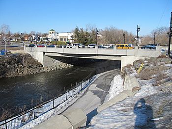
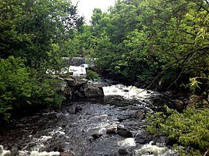
North Yamaska River downstream from Patrick-Hackett bridge.
|
|
| Native name | Rivière Yamaska Nord |
| Country | Canada |
| Province | Quebec |
| Administrative region | Montérégie |
| MRC | La Haute-Yamaska Regional County Municipality, Brome-Missisquoi Regional County Municipality |
| Physical characteristics | |
| Main source | Lac Waterloo Waterloo 204 units? 45°20′34″N 72°31′14″W / 45.342826°N 72.520628°W |
| River mouth | Yamaska River Brigham 73 m 45°17′20″N 72°51′14″W / 45.28889°N 72.85389°W |
| Length | 47.8 km (29.7 mi) |
| Basin features | |
| River system | Saint Lawrence River |
| Basin size | 303 km2 (117 sq mi) |
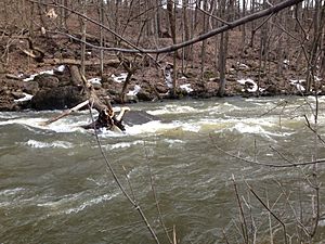
The North Yamaska River (or Rivière Yamaska Nord in French) is a smaller river that flows into the Yamaska River. It travels about 47.8 kilometers (29.7 miles) in southern Quebec, Canada. This river is on the south side of the big Saint Lawrence River. It flows through five towns and villages, and some of them even get their drinking water from it!
The North Yamaska River is very important for all the life around it. However, building new towns, farming, and factories have caused some problems for the ecosystem. This has been happening since people first settled in the Eastern Townships.
Luckily, people are now more aware of pollution in the North Yamaska. Many groups are working together to help the river. They create art projects and take eco-friendly actions. Local towns and their regional areas are trying to reduce the impact of human activities on the river's water quality.
Contents
What's in a Name?
The official name, "North Yamaska River" (Rivière Yamaska Nord), was given on December 5, 1968. Before that, people called it the Granby River or the Waterloo River.
The name "Yamaska" might come from the Abenaki language. It could mean "there are rushes in the water" or "there is much hay". This makes sense because the area where the river meets the Yamaska River has lots of wet land and plants. Another idea is that it comes from the Algonquin language "hia muskeg," meaning "savanna river" or "muddy water river."
This river is called "North" Yamaska because it flows from the north when it joins the main Yamaska River.
Where Does the River Flow?
How Much Water Does it Hold?
The area that drains into this river, called its drainage basin, covers 303 square kilometers (117 square miles). The river's average water flow is about 0.59 cubic meters per second. This amount changes with the seasons.
The North Yamaska River starts at Waterloo Lake (lac Waterloo), which is 204 meters (669 feet) high. This lake is south of the village of Waterloo. The river then curves around the north side of mont Shefford.
The River's Journey
The North Yamaska River's journey can be split into two main parts.
Upper Part of the River (17 km)
From Waterloo Lake, the North Yamaska River flows:
- 5.4 kilometers (3.4 miles) north. It collects water from lac Enchanté and lac des Sources until it reaches the village of Warden.
- 1.9 kilometers (1.2 miles) north until it meets a creek coming from the east.
- 5.9 kilometers (3.7 miles) northwest to the end of a bay in the Choinière reservoir.
- 3.8 kilometers (2.4 miles) west, crossing the Choinière reservoir. This reservoir is 4.9 kilometers (3.0 miles) long and sits at an altitude of 143 meters (469 feet).
Lower Part of the River (30.8 km)
From the dam west of the Choinière reservoir, the North Yamaska flows:
- 7.4 kilometers (4.6 miles) southwest to a retention basin on the east side of lac Boivin (Boivin Lake). This lake is 110 meters (361 feet) high.
- 3.5 kilometers (2.2 miles) southwest, crossing Boivin Lake, which is in the town of Granby.
- 10.0 kilometers (6.2 miles) southwest through Granby until it reaches Highway 10.
- 9.9 kilometers (6.2 miles) southwest through farm lands until it reaches its end.
The North Yamaska River then joins the north side of the Yamaska River near Adamsville and Farnham.
Towns and Regions Along the River
The North Yamaska River flows through several towns and regions:
- La Haute-Yamaska: This includes Waterloo, Saint-Joachim-de-Shefford, Granby, and Saint-Alphonse-de-Granby.
- Brome-Missisquoi: This includes Brigham.
Animals and Plants of the River
Many different animals and plants live in or depend on the North Yamaska River. These change a lot from one season to another. Because the river is so rich in nature, people use it for both business and fun activities.
The river flows slowly, has many species of fish, and is close to artificial lakes and a national park. This makes it a very popular place for fishing and tourism in the Eastern Townships. However, pollution from pesticides and farm runoff is a problem for the native animals and plants. It also affects people who want to enjoy the river's nature. To help, the government of Quebec sometimes adds certain fish to the river that can handle some pollution.
The plants around the North Yamaska River are a mix of trees and marsh plants. In winter, most plants are dormant, except for pine trees. There are fewer animal species in winter, but they are easier to see. In the spring, animals that were sleeping wake up, and migratory birds return. They stay until fall and are very active around the river.
Fish in the River
Scientists studied the fish in the North Yamaska River in 1995 and 2003. Other studies were done in 1998 or 1999. These studies helped create a list of 33 types of fish that live in the river. Some of these include:
- Largemouth bass (Micropterus salmoides)
- Smallmouth bass (Micropterus dolomieu)
- Brown bullhead (Ameiurus nebulosus)
- Chain pickerel (Esox niger)
- Common carp (Cyprinus carpio)
- Silver redhorse (Moxostoma anisurum)
- Shorthead redhorse (Moxostoma macrolepidotum)
- Rock bass (Ambloplites rupestris)
- Pumpkinseed (Lepomis gibbosus)
- Common logperch (Percina caprodes)
- Northern pike (Esox lucius)
- Fathead minnow (Pimephales promelas)
- Bluntnose minnow (Pimephales notatus)
- Spottail shiner (Notropis hudsonius)
- Rosyface shiner (Notropis rubellus)
- Spotfin shiner (Cyprinella spiloptera)
- Eastern silvery minnow (Hybognathus regius)
- Emerald shiner (Notropis atherinoides)
- Golden shiner (Notemigonus crysoleucas)
- Sand shiner (Notropis stramineus)
- Mimic shiner (Notropis volucellus)
- White sucker (Catostomus commersonii)
- Creek chub (Semotilus atromaculatus)
- Longnose dace (Rhinichthys cataractae)
- Eastern blacknose dace (Rhinichthys atratulus)
- Brook trout (Salvelinus fontinalis)
- Fallfish (Semotilus corporalis)
- Yellow perch (Perca flavescens)
- Tessellated darter (Etheostoma olmstedi)
- Rainbow trout (Oncorhynchus mykiss)
- Brown trout (Salmo trutt)
- Central mudminnow (Umbra limi)
Birds Around the River
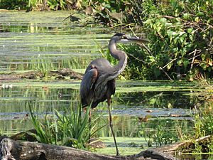
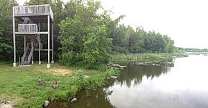
Groups like ÉPOQ (Study of Bird Populations of Quebec) count birds in Quebec. The North Yamaska River is very important for birds because of the large swamps around Boivin Lake and the Yamaska National Park. The local birdwatching club, COOHY, also collects data on birds here.
Many bird species live here all year. However, a large number fly south in the autumn and return in the spring. Because there is water, many water birds live here. Some of the most common and impressive ones are the great blue heron, the double-crested cormorant, and the Canada goose. Water also attracts lots of insects, which means many birds live by the river for food.
Mammals Near the Water
Mink, beaver, and muskrat are the main mammals that live in the North Yamaska River's waters. Most land animals also come to drink from the river or hunt amphibians or reptile eggs on its banks. Some common land mammals include the striped skunk, raccoon, and white-tailed deer.
Protecting the River
For many years, people living near the Yamaska River have tried to reduce the negative impact that humans have on the nature that depends on it. You can see more and more community art projects, events, and information shared about the river. People are also encouraged to live in an eco-friendly way, take responsibility, and appreciate nature.
Granby's Efforts to Help
Granby is one of the towns that takes direct action to improve the river's health. The city holds public meetings and uses expert studies to plan for the future of Lac Boivin. Granby also supports murals with environmental messages on public walls and buildings. They work with non-profit groups and citizens who care about the environment.
Art for the Yamaska
"Yamaska Emergency" Art Project
A non-profit group from Granby, Atelier 19 art et créativité, started a special project. They held workshops where volunteer citizens created two large mural artworks. These murals were hung on the A-B-C pumping station. This is a good spot because the station pumps drinking water from the North Yamaska River for the town. It is also close to the river and Boivin Lake, which makes the art more impactful.
One artwork, Urgence Yamaska (Yamaska Emergency), is a call for help for the river and its creatures. The other, La Yamaska, c'est nous (The Yamaska, it is us), has nine panels with information about the river's water and the life in it. Both artworks were shown on May 11, 2013, during the river's yearly celebration. The messages in these murals came from many people thinking together about the river's health. You can easily see the murals from the bike paths around Lac Boivin.
"What Have You Become, Yamaska?"
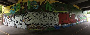
Two years later, a follow-up to the Art-Yamaska project took place under the Patrick-Hackett bridge. This bridge is a bit further down the North Yamaska, in downtown Granby. This time, youth participated in eight workshops at the Centre culturel France-Arbour and Atelier 19. These workshops focused on graffiti art and aimed to create a mural with a message about the environment and living respectfully with nature.
The underside of the bridge often had illegal graffiti. Some of the old art was kept, but the top and sides were changed into a unique artwork about the Yamaska River. The mural's official title, "Qu'es-tu devenu, Yamaska?" (Yamaska, what have you become?), is hand-painted in a graffiti style. Over thirty volunteers of all ages helped create it. The idea for the message came from a group of young people in the region who care deeply about the environment.
 | Aurelia Browder |
 | Nannie Helen Burroughs |
 | Michelle Alexander |


