Osage County, Oklahoma facts for kids
Quick facts for kids
Osage County
|
|
|---|---|

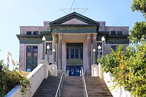
Osage County Courthouse
|
|

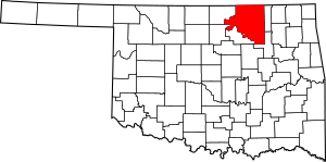
Location within the U.S. state of Oklahoma
|
|
 Oklahoma's location within the U.S. |
|
| Country | |
| State | |
| Founded | 1907 |
| Named for | Osage Nation |
| Seat | Pawhuska |
| Largest city | Hominy |
| Area | |
| • Total | 2,304 sq mi (5,970 km2) |
| • Land | 2,246 sq mi (5,820 km2) |
| • Water | 58 sq mi (150 km2) 2.5% |
| Population
(2020)
|
|
| • Total | 45,818 |
| • Density | 19.886/sq mi (7.6781/km2) |
| Congressional district | 3rd |
Osage County is the largest county in Oklahoma by land area. It was created in 1907 when Oklahoma became a state. The county is named after the Osage Nation, a Native American tribe.
Osage County is special because it covers the same area as the Osage Nation Reservation. This reservation was set up by a treaty in the 1800s. The county seat, or main town, is Pawhuska. Pawhuska was one of the first three towns built in the county. In 2020, about 45,818 people lived in Osage County.
Contents
History of Osage County
Early History of the Osage Nation
In the 1600s, the Osage and other tribes moved west from the Ohio area. They became a strong nation in what is now Missouri and Arkansas. By 1760, their lands included the area of present-day Osage County. The Osage were one of the most powerful tribes on the Great Plains. However, their numbers decreased due to diseases and wars after meeting Europeans.
In 1825, the Osage gave up their claim to land in Oklahoma to the U.S. government. This land was later given to the Cherokee Nation in 1835. This was part of a plan to move the Cherokee to Indian Territory. During the American Civil War, some battles happened in the area.
Osage Relocation and Reservation
In 1870, the Osage tribe moved from Kansas to Oklahoma. They bought 1.57 million acres of their old land from the Cherokee. This meant they owned the land directly, which gave them more power. The Osage Agency, their main office, was set up in 1872 in Deep Ford. This place was later renamed Pawhuska. Pawhuska became the county seat when Oklahoma became a state. Other important settlements in the 1870s were Hominy and Fairfax.
In 1875, the U.S. government officially made this land the Osage Reservation. Because the tribe owned the land, they had more control over their lives. This was different from other tribes whose land was held "in trust" by the government. The reservation became part of the Oklahoma Territory in 1890. It became Osage County when Oklahoma became a state in 1907. At that time, there were 2,229 registered Osage members.
Oil Discovery and Wealth
The Osage Nation kept the rights to the minerals under their land, like oil. In 1897, the first successful oil well was drilled on the Osage reservation. In 1901, a company called Indian Territory Illuminating Oil Company (ITIO) leased the eastern part of the reservation. When their lease ended, the U.S. government helped auction off new leases for oil drilling.
The Osage Nation still owns all the minerals, including oil, under their land. The U.S. government holds these rights for them. The Osage National Council, the tribe's government, approved each oil lease. Even though the government divided some land for farming in the early 1900s, the tribe kept their "surplus" land. This meant each Osage person received about 657 acres, much more than other Native American families. Later, Osage members and their descendants received money from oil and mineral royalties. These payments were called "headrights."
Challenges and Protection
By the 1920s, the Osage people were very wealthy from oil money. This wealth, however, brought many challenges. Some people tried to take advantage of the Osage. To protect the Osage, Congress passed a law in 1921. This law required Osage people with half or more Native American ancestry to have a guardian. These guardians were appointed by courts. Sadly, some guardians were dishonest and tried to gain control of Osage land and oil rights.
The Osage Nation asked the FBI for help with these problems. To further protect the Osage, Congress passed another law in 1925. This law limited who could inherit "headrights" to only those who were half or more Osage.
Geography
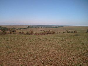
Osage County covers about 2,304 square miles. Most of this is land (2,246 square miles), and 58 square miles is water. It is the biggest county in Oklahoma by land area. Most of the county is open prairie, which is flat grassland. The eastern part has the Osage Hills, which are part of the Flint Hills in Kansas. The Tallgrass Prairie Preserve is a large protected area north of Pawhuska.
Holmes Peak is a mountain northwest of Tulsa in Osage County. It was named after the famous detective, Sherlock Holmes. Holmes Peak is the highest point in the Tulsa area, at 1,030 feet tall.
Several creeks and rivers flow through Osage County. The Arkansas River forms part of the county's southern and western borders. Other streams like the Caney River and Bird Creek flow into the Verdigris River.
Lakes in Osage County
Osage County has several lakes and reservoirs, including:
In 2012, the Osage Nation took over managing Wah-Sha-She State Park, which includes Hulah Lake. This happened after state budget cuts might have closed the park. The land is owned by the U.S. Army Corps of Engineers.
Adjacent Counties
Osage County shares borders with these other counties:
- Cowley County, Kansas (northwest)
- Chautauqua County, Kansas (north)
- Washington County (east)
- Tulsa County (southeast)
- Pawnee County (southwest)
- Kay County (west)
- Noble County (west)
Population and People
The population of Osage County has changed over the years. In 1910, about 20,101 people lived here. By 2010, the population grew to 47,472. In 2020, it was 45,818.
In 2010, there were 18,205 households in the county. About 32.6% of these households had children under 18. Many households were married couples living together. The average household had 2.53 people. The median age of people in the county was 41.4 years.
The median income for a household in 2010 was $42,847. This means half of the households earned more than this, and half earned less. In 2021, the median household income was estimated to be $54,036. About 12.3% of the population lived below the poverty line in 2021.
Communities
Cities
- Barnsdall
- Bartlesville (part)
- Hominy
- Pawhuska
- Ponca City (part)
- Sand Springs (part)
- Skiatook (part)
- Shidler
- Tulsa (part)
Towns
Census-Designated Places
Education
School districts in Osage County include:
K-12 Schools
- Barnsdall Public Schools
- Bartlesville Public Schools
- Caney Valley Public Schools
- Cleveland Public Schools
- Dewey Public Schools
- Hominy Public Schools
- Pawhuska Public Schools
- Ponca City Public Schools
- Prue Public Schools
- Sand Springs Public Schools
- Shidler Public Schools
- Skiatook Public Schools
- Sperry Public Schools
- Tulsa Public Schools
- Woodland Public Schools
- Wynona Public Schools
Elementary Schools Only
- Anderson Public School
- Avant Public School
- Bowring Public School
- McCord Public School
- Osage Hills Public School
Historic Places (NRHP sites)
Many places in Osage County are listed on the National Register of Historic Places. This means they are important historical sites. Some of these include:
- Bank of Bigheart, Barnsdall
- Bank of Burbank, Burbank
- Bank of Hominy, Hominy
- Barnsdall Main Street Well Site, Barnsdall
- Blacksmith's House, Pawhuska
- Chapman-Barnard Ranch Headquarters, Pawhuska
- Chief Ne-Kah-Wah-She-Tun-Kah Grave and Statue, Fairfax
- Pawhuska City Hall, Pawhuska
- Fred and Adeline Drummond House, Hominy
- First National Bank and Masonic Lodge, Fairfax
- Hominy Armory, Hominy
- Hominy Osage Round House, Hominy
- Hominy School, Hominy
- Immaculate Conception Church, Pawhuska
- Lincoln Colored School, Fairfax
- Marland Filling Station, Hominy
- Osage Agency, Pawhuska
- Osage Bank of Fairfax, Fairfax
- Osage County Courthouse, Pawhuska
- Pawhuska Armory, Pawhuska
- Pawhuska Downtown Historic District, Pawhuska
- Wolverine Oil Company Drayage Barn, Avant
- Osage Nation Museum, Pawhuska
Highways
Major highways that pass through Osage County include:
- L.L. Tisdale Parkway
- Gilcrease Expressway
- U.S. 412
- U.S. 60
- Oklahoma State Highway 99
- Oklahoma State Highway 20
- Oklahoma State Highway 18
- Oklahoma State Highway 11
- Oklahoma State Highway 10
- Oklahoma State Highway 123
- Oklahoma State Highway 97
Images for kids
See also
 In Spanish: Condado de Osage (Oklahoma) para niños


