Sandisfield, Massachusetts facts for kids
Quick facts for kids
Sandisfield, Massachusetts
|
||
|---|---|---|

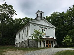
The Sandisfield Arts Center
|
||
|
||

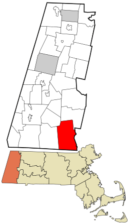
Location in Berkshire County and the state of Massachusetts.
|
||
| Country | United States | |
| State | Massachusetts | |
| County | Berkshire | |
| Settled | 1750 | |
| Incorporated | 1762 | |
| Government | ||
| • Type | Open town meeting | |
| Area | ||
| • Total | 53.0 sq mi (137.2 km2) | |
| • Land | 51.8 sq mi (134.2 km2) | |
| • Water | 1.2 sq mi (3.0 km2) | |
| Elevation | 1,577 ft (481 m) | |
| Population
(2020)
|
||
| • Total | 989 | |
| • Density | 18.670/sq mi (7.208/km2) | |
| Time zone | UTC-5 (Eastern) | |
| • Summer (DST) | UTC-4 (Eastern) | |
| ZIP Code |
01255
|
|
| Area code(s) | 413 | |
| FIPS code | 25-59665 | |
| GNIS feature ID | 0619426 | |
Sandisfield is a small town located in Berkshire County, Massachusetts, in the United States. It's known as a "New England town," which is a special type of local government common in this part of the country. In 2020, about 989 people lived here. It is also part of the larger Pittsfield area.
Contents
Sandisfield's Early Days
Sandisfield was first settled in 1750. Back then, it was called Housatonic Township Number 4. The town officially became a town in 1762. It was probably named after Lord Sandys, a British official. His name is pronounced "Sands."
In its early years, Sandisfield was mainly a farming community. People grew rye and had many fruit orchards. There were also several sawmills built along the rivers. These mills used water power to cut wood.
However, most of the town's industries didn't last. This happened in the late 1800s. A planned railway along the Farmington River was never built, which hurt the town's growth. Later, many Ukrainian farmers moved to Sandisfield. They often ran chicken farms.
Community Life Today
Sandisfield has a history of local newspapers. The Record was published from 1981 to 1985. The Newsletter was printed for ten years in the 1990s.
Since 2009, volunteers have published the Sandisfield Times. It comes out 11 times a year. Today, Sandisfield is mostly a rural area. It is one of the least crowded parts of Massachusetts.
Exploring Sandisfield's Geography
Sandisfield covers about 137.2 square kilometers (53 square miles). Most of this area, about 134.2 square kilometers (51.8 square miles), is land. The rest, about 3.0 square kilometers (1.2 square miles), is water.
This makes Sandisfield the largest town by land area in Berkshire County. It is also the eighth largest in the entire state of Massachusetts.
Location and Neighbors
Sandisfield is in the southeast corner of Berkshire County. It shares a border with Connecticut to the south. Hampden County is to its east.
The town is surrounded by other towns:
- Otis to the north and northeast
- Tolland to the east
- Colebrook and Norfolk, Connecticut to the south
- New Marlborough to the west
- Monterey to the northwest
Sandisfield is about 45 kilometers (28 miles) south-southeast of Pittsfield. It's also about 51 kilometers (32 miles) west of Springfield. Boston is much further away, about 190 kilometers (118 miles) to the west-southwest.
Rivers and Forests
Sandisfield is located in the southeastern part of the Berkshire Mountains. The Farmington River flows along the town's western side. The town sits on a high flat area, called a plateau.
The Buck and Clam rivers also flow through Sandisfield. They eventually join the Farmington River. There are also many small, marshy streams and little ponds and lakes.
Parts of the Sandisfield State Forest are scattered throughout the town. The highest point in Sandisfield is Abbey Hill. It stands about 552 meters (1,810 feet) tall. Abbey Hill is located in the northwest part of the forest. A small piece of Otis State Forest also extends into the northern part of Sandisfield.
Roads and Travel
Massachusetts Route 8 runs along the Farmington River on the eastern side of town. Route 57 crosses the middle of town from west to east. It crosses the river into Tolland at a village called New Boston.
Route 183 goes through the southwest corner of town. It then crosses into Connecticut and becomes Connecticut Highway 183. The closest major highway, Interstate 90 (also known as the Massachusetts Turnpike), passes north of Sandisfield through Otis. The nearest places to get on this highway are in Lee and Westfield.
There are no train services in Sandisfield. The closest train and bus services are in Great Barrington. For air travel, the nearest local airport is also in Great Barrington. For bigger flights, the closest national airport is Bradley International Airport in Windsor Locks, Connecticut.
Sandisfield's Population Over Time
| Historical population | ||
|---|---|---|
| Year | Pop. | ±% |
| 1776 | 1,044 | — |
| 1790 | 1,581 | +51.4% |
| 1800 | 1,637 | +3.5% |
| 1810 | 1,648 | +0.7% |
| 1820 | 1,646 | −0.1% |
| 1830 | 1,655 | +0.5% |
| 1840 | 1,464 | −11.5% |
| 1850 | 1,649 | +12.6% |
| 1860 | 1,585 | −3.9% |
| 1870 | 1,482 | −6.5% |
| 1880 | 1,107 | −25.3% |
| 1890 | 807 | −27.1% |
| 1900 | 661 | −18.1% |
| 1910 | 566 | −14.4% |
| 1920 | 460 | −18.7% |
| 1930 | 412 | −10.4% |
| 1940 | 421 | +2.2% |
| 1950 | 437 | +3.8% |
| 1960 | 536 | +22.7% |
| 1970 | 547 | +2.1% |
| 1980 | 720 | +31.6% |
| 1990 | 667 | −7.4% |
| 2000 | 824 | +23.5% |
| 2010 | 915 | +11.0% |
| 2020 | 989 | +8.1% |
| 2022* | 982 | −0.7% |
| * = population estimate. Source: United States Census records and Population Estimates Program data. |
||
In 2010, there were 915 people living in Sandisfield. These people lived in 327 households, and 212 of these were families. Sandisfield ranks 23rd in population out of the 32 towns in Berkshire County. It is also the 330th most populated out of 351 towns in Massachusetts.
The town has a low population density, meaning there aren't many people living close together. There were about 15.7 people per square mile (6.1 per square kilometer). This makes it one of the least crowded places in the county and state.
Most of the people in Sandisfield are White (96.84%). A small number are African American, Native American, or Asian. Some people identify as being of two or more races. About 0.97% of the population is Hispanic or Latino.
Household Information
About 24.8% of households in Sandisfield had children under 18 living there. Most households (58.4%) were married couples living together. About 4.0% had a female head of household with no husband.
About 30.0% of all households were single individuals. And 11.9% of households had someone living alone who was 65 years or older. The average household had 2.37 people, and the average family had 2.99 people.
Age and Income
The population in Sandisfield is spread out by age. About 20.1% of residents are under 18 years old. About 18.0% are 65 years or older. The average age in town was 45 years old.
The median income for a household in Sandisfield was $45,972. For families, the median income was $57,083. The average income per person in the town was $27,628. A small number of families (1.3%) and people (2.4%) lived below the poverty line.
Learning in Sandisfield
Sandisfield is part of the Farmington River Regional School District, along with the nearby town of Otis. Sandisfield used to have its own school, but it closed in 1998 due to budget cuts.
The only school in the district is Farmington River Elementary School, located in Otis. This school teaches students from pre-kindergarten up to sixth grade.
For older students, most attend W.E.B. DuBois Regional Middle School. They then go to Monument Mountain Regional High School in Great Barrington. Some students also attend Lee Public School Districts or Mt. Everett Regional High School in Sheffield. There are also private schools available in Great Barrington, Lee, and Westfield.
For higher education, the closest community college is Berkshire Community College in Pittsfield and Sheffield. The nearest state university is Westfield State University. For private colleges, Bard College at Simon's Rock is in Great Barrington, and other private colleges are in Springfield.
Notable People from Sandisfield
- Mary Sears McHenry (1834–1912): She was the president of the Women's Relief Corps in 1890. At that time, it was the largest group of its kind in the United States.
- James Worden (1819–1884): He was a Justice on the Indiana Supreme Court. He also served as the mayor of Fort Wayne, Indiana.
See also
 In Spanish: Sandisfield (Massachusetts) para niños


