
Smith County, Kansas facts for kids
Quick facts for kids
Smith County
|
|
|---|---|

Home on the Range Cabin near Smith Center (2014)
|
|

Location within the U.S. state of Kansas
|
|
 Kansas's location within the U.S. |
|
| Country | |
| State | |
| Founded | 1872 |
| Named for | J. Nelson Smith |
| Seat | Smith Center |
| Largest city | Smith Center |
| Area | |
| • Total | 897 sq mi (2,320 km2) |
| • Land | 895 sq mi (2,320 km2) |
| • Water | 1.5 sq mi (4 km2) 0.2% |
| Population
(2020)
|
|
| • Total | 3,570 |
| • Estimate
(2023)
|
3,590 |
| • Density | 3.980/sq mi (1.5367/km2) |
| Time zone | UTC−6 (Central) |
| • Summer (DST) | UTC−5 (CDT) |
| Area code | 785 |
| Congressional district | 1st |
Smith County is a county located in the state of Kansas in the United States. Its main town and government center is Smith Center. In 2020, about 3,570 people lived here. The county is named after J. Nelson Smith, a brave soldier who died in a battle in 1864. A special spot, the exact center of the lower 48 states, is found in Smith County, close to the town of Lebanon.
Contents
History of Smith County
Early Times in Kansas
For thousands of years, the wide-open Great Plains of North America were home to nomadic Native American groups. They moved around to hunt and find food.
From the 1500s to the 1700s, the country of France said they owned large parts of North America. But in 1762, after a big war, France secretly gave a huge area, called New France, to Spain. This was part of a deal known as the Treaty of Fontainebleau.
The 1800s and Growth
In 1802, Spain gave most of this land back to France. Then, in 1803, the United States bought a huge amount of land from France. This was called the Louisiana Purchase. It included most of what is now Kansas. The U.S. paid a very small amount for each acre.
In 1854, the Kansas Territory was set up. Then, in 1861, Kansas officially became the 34th U.S. state. Smith County was created in 1872. The first settlers arrived in 1871. By 1875, about 3,800 people lived in the county. The population grew to 15,000 by 1889!
At first, corn was the main crop. But dry weather and grasshopper swarms caused problems. Later, a strong type of Winter wheat was brought to Kansas by settlers from Russia. This wheat grew well and became the most important crop in Smith County. Since 1900, the number of people in the county has slowly gone down. This is mainly because new farming machines mean fewer people are needed to work the land.
In 1873, Brewster Higley wrote the famous song "Home on the Range". He wrote it in a small cabin about 9 miles northwest of Smith Center. This song later became the official song of Kansas.
Geography of Smith County
Smith County covers about 897 square miles. Most of this area, about 895 square miles, is land. Only a small part, about 1.5 square miles, is water. The county is divided into 25 smaller areas called townships.
A very important spot is located in Smith County: the geographic center of the lower 48 states. This spot is near the town of Lebanon. The geographic center of all of North America is in the next county over, Osborne County.
The Solomon River flows through the southern part of Smith County. This river creates a flat area and provides water for farms that use irrigation.
Main Roads in Smith County
Two main highways help people travel through Smith County.
- U.S. Highway 36 goes from east to west, passing through Athol, Kensington, and Smith Center.
- U.S. Highway 281 goes from north to south and crosses US-36 in Smith Center.
Other state highways like K-8, K-9, and K-180 also serve different parts of the county.
Neighboring Counties
Smith County shares borders with several other counties:
- Webster County, Nebraska (to the northeast)
- Jewell County (to the east)
- Osborne County (to the south)
- Rooks County (to the southwest)
- Phillips County (to the west)
- Franklin County, Nebraska (to the northwest)
People of Smith County

| Historical population | |||
|---|---|---|---|
| Census | Pop. | %± | |
| 1870 | 66 | — | |
| 1880 | 13,883 | 20,934.8% | |
| 1890 | 15,613 | 12.5% | |
| 1900 | 16,384 | 4.9% | |
| 1910 | 15,365 | −6.2% | |
| 1920 | 14,985 | −2.5% | |
| 1930 | 13,545 | −9.6% | |
| 1940 | 10,582 | −21.9% | |
| 1950 | 8,846 | −16.4% | |
| 1960 | 7,776 | −12.1% | |
| 1970 | 6,757 | −13.1% | |
| 1980 | 5,947 | −12.0% | |
| 1990 | 5,078 | −14.6% | |
| 2000 | 4,536 | −10.7% | |
| 2010 | 3,853 | −15.1% | |
| 2020 | 3,570 | −7.3% | |
| 2023 (est.) | 3,590 | −6.8% | |
| U.S. Decennial Census 1790-1960 1900-1990 1990-2000 2010-2020 |
|||
In 2000, there were 4,536 people living in Smith County. There were 1,953 households, and 1,322 families. The county had about 5 people per square mile. Most people (98.79%) were White. A small number were Black, Native American, Asian, or Pacific Islander. About 0.73% of the people were Hispanic or Latino.
About 25.60% of households had children under 18 living with them. Most households (60.60%) were married couples. About 30.20% of all households were people living alone. Many people (18.60%) living alone were 65 years old or older. The average household had 2.27 people. The average family had 2.78 people.
The population was spread out by age. About 21.70% were under 18. About 27.90% were 65 or older. The average age was 46 years. For every 100 females, there were about 92.70 males.
The average income for a household in the county was $28,486. For a family, it was $36,951. About 10.70% of the people in the county lived below the poverty line. This included 12.80% of those under 18 and 9.50% of those 65 or older.
Education in Smith County
School Districts
Students in Smith County attend schools in these unified school districts:
- Thunder Ridge USD 110
- Smith Center USD 237
Communities in Smith County

Smith County has several cities, smaller communities, and even some "ghost towns" where people used to live.
Cities in Smith County
- Athol
- Cedar
- Gaylord
- Kensington
- Lebanon
- Smith Center (This is the county seat, where the main government offices are.)
Unincorporated Communities
These are smaller communities that are not officially cities:
Ghost Towns
These are places where towns once existed but are now mostly empty or gone:
- Anderson
- Clifford
- Cora
- Corvallis
- Covington
- Crystal Plains
- Custer
- Germantown
- Hardilee
- Jacksonburg
- Judson
- Ohio
- Troublesome
- Twelve Mile
- Tyner
- Uhl
Townships in Smith County
Smith County is divided into 25 areas called townships. The numbers for each township include the people living in any cities within that township.
| Township | FIPS | Population center |
Population | Population density /km2 (/sq mi) |
Land area km2 (sq mi) |
Water area km2 (sq mi) |
Water % | Geographic coordinates |
|---|---|---|---|---|---|---|---|---|
| Banner | 04100 | 54 | 0.58 (1.50) | 93.29 (36.02) | 0 (0) | 0% | 39°42′3″N 98°47′13″W / 39.70083°N 98.78694°W | |
| Beaver | 05200 | 60 | 0.65 (1.67) | 92.89 (35.86) | 0.27 (0.10) | 0.29% | 39°56′50″N 98°46′34″W / 39.94722°N 98.77611°W | |
| Blaine | 07200 | 60 | 0.64 (1.67) | 93.24 (36.00) | 0.04 (0.01) | 0.04% | 39°47′20″N 98°40′48″W / 39.78889°N 98.68000°W | |
| Cedar | 11350 | Kensington | 619 | 6.68 (17.29) | 92.71 (35.80) | 0.08 (0.03) | 0.09% | 39°46′10″N 99°1′50″W / 39.76944°N 99.03056°W |
| Center | 12175 | Smith Center | 2,094 | 22.48 (58.22) | 93.15 (35.97) | 0.04 (0.02) | 0.05% | 39°46′47″N 98°47′7″W / 39.77972°N 98.78528°W |
| Cora | 15525 | 38 | 0.41 (1.06) | 92.96 (35.89) | 0.17 (0.06) | 0.18% | 39°52′45″N 98°40′7″W / 39.87917°N 98.66861°W | |
| Crystal Plains | 16575 | 40 | 0.43 (1.11) | 93.00 (35.91) | 0.05 (0.02) | 0.05% | 39°41′27″N 98°40′52″W / 39.69083°N 98.68111°W | |
| Dor | 18300 | 46 | 0.50 (1.29) | 92.55 (35.73) | 0.30 (0.11) | 0.32% | 39°37′33″N 99°0′4″W / 39.62583°N 99.00111°W | |
| Garfield | 25825 | 33 | 0.35 (0.92) | 92.96 (35.89) | 0.04 (0.02) | 0.04% | 39°35′48″N 98°40′21″W / 39.59667°N 98.67250°W | |
| German | 26150 | 34 | 0.37 (0.96) | 91.78 (35.44) | 0.27 (0.10) | 0.29% | 39°56′41″N 99°0′39″W / 39.94472°N 99.01083°W | |
| Harlan | 30100 | 100 | 1.07 (2.78) | 93.03 (35.92) | 0.05 (0.02) | 0.05% | 39°36′25″N 98°46′42″W / 39.60694°N 98.77833°W | |
| Harvey | 30550 | Cedar | 130 | 1.40 (3.63) | 92.86 (35.85) | 0.00 (0.00) | 0% | 39°41′10″N 98°55′32″W / 39.68611°N 98.92556°W |
| Houston | 33225 | Gaylord | 206 | 2.22 (5.74) | 92.94 (35.88) | 0.14 (0.05) | 0.15% | 39°37′38″N 98°52′12″W / 39.62722°N 98.87000°W |
| Lane | 38450 | Athol | 134 | 1.44 (3.73) | 92.98 (35.90) | 0.03 (0.01) | 0.04% | 39°46′49″N 98°53′30″W / 39.78028°N 98.89167°W |
| Lincoln | 41200 | 73 | 0.79 (2.04) | 92.80 (35.83) | 0.15 (0.06) | 0.16% | 39°36′13″N 98°33′23″W / 39.60361°N 98.55639°W | |
| Logan | 42275 | 47 | 0.51 (1.32) | 92.50 (35.72) | 0.14 (0.05) | 0.15% | 39°57′5″N 98°34′4″W / 39.95139°N 98.56778°W | |
| Martin | 45000 | 24 | 0.26 (0.67) | 92.49 (35.71) | 0.25 (0.10) | 0.27% | 39°56′40″N 98°54′21″W / 39.94444°N 98.90583°W | |
| Oak | 51650 | Lebanon | 399 | 4.30 (11.13) | 92.88 (35.86) | 0.07 (0.03) | 0.07% | 39°48′10″N 98°33′29″W / 39.80278°N 98.55806°W |
| Pawnee | 54825 | 35 | 0.38 (0.98) | 92.13 (35.57) | 0.41 (0.16) | 0.44% | 39°57′7″N 98°39′50″W / 39.95194°N 98.66389°W | |
| Pleasant | 56300 | 34 | 0.37 (0.95) | 92.69 (35.79) | 0.05 (0.02) | 0.05% | 39°51′28″N 98°54′28″W / 39.85778°N 98.90778°W | |
| Swan | 69625 | 42 | 0.46 (1.18) | 92.00 (35.52) | 0.23 (0.09) | 0.25% | 39°52′56″N 99°1′12″W / 39.88222°N 99.02000°W | |
| Valley | 73175 | 75 | 0.81 (2.09) | 92.82 (35.84) | 0.015 (0.006) | 0.02% | 39°41′28″N 98°59′59″W / 39.69111°N 98.99972°W | |
| Washington | 75775 | 63 | 0.68 (1.76) | 92.87 (35.86) | 0 (0) | 0% | 39°52′54″N 98°46′24″W / 39.88167°N 98.77333°W | |
| Webster | 76275 | 47 | 0.51 (1.31) | 92.76 (35.82) | 0.02 (0.01) | 0.02% | 39°42′27″N 98°34′8″W / 39.70750°N 98.56889°W | |
| White Rock | 78000 | 49 | 0.53 (1.37) | 92.88 (35.86) | 0.04 (0.02) | 0.04% | 39°52′37″N 98°33′5″W / 39.87694°N 98.55139°W |
Images for kids
-
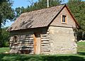
Home on the Range Cabin near Smith Center (2014)
-
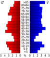
A chart showing the number of people in different age groups in Smith County based on the 2000 census.
-
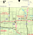
A 2005 map showing the towns and areas of Smith County.
See also
 In Spanish: Condado de Smith (Kansas) para niños
