St Mary Cray facts for kids
Quick facts for kids St Mary Cray |
|
|---|---|
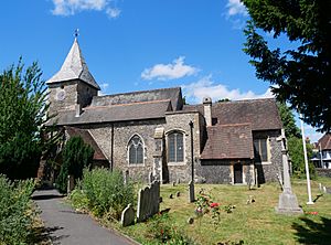 The Church of St Mary in St Mary Cray |
|
| OS grid reference | TQ466680 |
| • Charing Cross | 13 mi (21 km) NW |
| London borough | |
| Ceremonial county | Greater London |
| Region | |
| Country | England |
| Sovereign state | United Kingdom |
| Post town | ORPINGTON |
| Postcode district | BR5 |
| Dialling code | 01689 |
| Police | Metropolitan |
| Fire | London |
| Ambulance | London |
| EU Parliament | London |
| UK Parliament |
|
| London Assembly |
|
St Mary Cray is an area in South East London, England. It is part of the London Borough of Bromley. Long ago, it was a market town in the county of Kent. You can find it north of Orpington, about 13 miles (21 km) south-east of Charing Cross.
Contents
History of St Mary Cray
The name Cray might come from an old Anglo-Saxon word, crecca, which means a small stream. It could also be from the Welsh word craie, meaning fresh water. Another idea is that it comes from the Latin word creta, meaning chalk. This is because the River Cray flows over a chalky riverbed. The "St Mary" part of the name comes from the local church, which is dedicated to the Virgin Mary.
People have found signs of Roman and Saxon life in the Fordcroft area. In 1960, a dig was done by members of the Bromley Museum. Later, the Orpington and District Archaeological Society (ODAS) explored more sites.
St Mary Cray grew into a busy market town. King Edward I (who ruled from 1272 to 1307) gave the town permission to hold a market every Wednesday.
This area was mostly farmland. Many people worked on fruit farms and in hop fields. Hops are used to make beer.
One of the earliest famous industries here was bell-making in the 1600s. Foundries run by Hodson and Hull made many famous bells. Christopher Hodson even made bells for Canterbury Cathedral.
Later, during the Industrial Revolution, brewing and paper making became big industries. These businesses were built next to the River Cray. Records from 1087 mention three mills here. From the early 1800s until the 1930s, many people worked at the Joynson and William Nash paper mills.
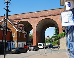
When railways expanded, more people moved to St Mary Cray. The building of the railway bridge over the Cray Valley in 1860 is linked to the start of Cray Wanderers F.C.. This is London's oldest football club. Workers came to build the huge earth banks for the London, Chatham & Dover Railway. Football games started at Star Lane, which is now a cemetery.
In the 1930s, the farmlands of Poverest were used to build factories and offices. The factories along Cray Avenue made things like paint, ink, baked goods, and preserved foods.
During and after World War II, Star Lane cemetery became a burial place for airmen. These included members of the RAF and other Commonwealth Air Forces. Three Polish airmen were also buried here. One was Stanisław Grodzicki, who died in a plane crash over Croydon.
In 1971, the St Mary Cray Action Group was started. They put up a new village sign in 1992. In 1999, John Horam, who was the local Member of Parliament, said that "The Crays are truly a slice of Kent, on the edge of London, once rural, now full of housing and commerce."
Notable Events and Places
Cray Wanderers FC
Cray Wanderers F.C. St Mary Cray was the first home of Cray Wanderers FC. This football club is thought to have started in 1860. It might be the oldest football club in London.
Farming and Workers
In the past, the hop and fruit farms in the area needed many workers. People would travel to St Mary Cray to help with the harvests.
A Noteworthy Incident
On Saturday, April 24, 1954, a well-known disagreement happened. It was between two groups of young people, sometimes called "Edwardians" or "Teddy Boys." The local newspaper, the Orpington & Kentish Times, wrote about it. They called it a "Gang Battle" at the railway station. The groups were from Downham and St Paul's Cray. The newspaper said trouble started at a dance at St Paul's Cray Community Centre. Later, a fight happened at the local station. About 40 young people were held overnight by the police.
Geography and Shops
Like nearby St Paul's Cray, St Mary Cray has changed a lot. The town of Orpington has grown bigger and now has most of the main shops. Today, St Mary Cray has mostly suburban homes. Many working-class families live here. The town once had a long street of shops, even longer than Orpington High Street. Now, the Nugents Retail Park on Cray Avenue is a big shopping area. It has large stores like Marks and Spencers and Next.
Before Nugents opened, the industrial areas of St Mary Cray and St Paul's Cray were very important. Many factories grew here, especially those making "light electrical industries" products. In the 1950s, the area where Nugents is now had two large Morphy Richards factories. They made things like toasters and irons. They moved out of the area in the 1960s. Other areas now have stores like PC World, Homebase, and Currys. These stores often say they are "Orpington branches." The art deco tower of the Allied Bakery, which used to be Tip Top Bakeries, is a local landmark. Near the bakery is Lagoon Road. It got its name because in the 1930s, there was an outdoor swimming pool called the Blue Lagoon here.
Nearby Areas
St Mary Cray is next to several other areas:
- St Paul's Cray to the north-west and north
- Swanley to the north-east
- Crockenhill to the east
- Orpington to the south-east, south, and south-west
- Petts Wood to the west
Transport
Train Services
St Mary Cray station connects the area to other places by train.
- Southeastern trains go to London Victoria, Ashford International (via Maidstone East), and Gillingham.
- Thameslink trains go to London Blackfriars (via Catford) and Sevenoaks.
Bus Services
Many bus routes serve St Mary Cray:
- 51: To Woolwich (via St Pauls Cray, Foots Cray, Sidcup, Blackfen, Welling & Plumstead Common) OR to Orpington.
- 273: To Lewisham (via St Pauls Cray, Chislehurst, Coldharbour, Grove Park, Horn Park, Lee & Hither Green) OR to Petts Wood (via Poverest).
- 477: To Dartford (via Crockenhill, Swanley, Hextable & Wilmington) OR to Orpington.
- N199: To Trafalgar Square (via Orpington, Petts Wood, Bromley, Downham, Bellingham, Catford, Ladywell, Lewisham, Greenwich, Deptford, Surrey Quays, Canada Water, Bermondsey, London Bridge & Aldwych). This is a night bus service.
- B14: To Bexleyheath (via St Pauls Cray, Sidcup, Albany Park & Blendon) OR to Orpington.
- R1: To St Pauls Cray OR to Green Street Green (via Orpington & Chelsfield).
- R3: To Locksbottom (via Poverest & Petts Wood) OR to Orpington.
- R4: To Pauls Cray Hill OR to Locksbottom (via Orpington & Farnborough).
- R6: To Orpington.
- R11: To Sidcup (via St Pauls Cray & Foots Cray) OR to Green Street Green (via Orpington).
Notable People from St Mary Cray
- Allan Octavian Hume (1829-1912): He was a famous bird expert and helped start the Indian National Congress. He was born in St Mary Cray.
 | Precious Adams |
 | Lauren Anderson |
 | Janet Collins |


