Storm history of Hurricane Ivan facts for kids
| Category 5 major hurricane (SSHWS/NWS) | |
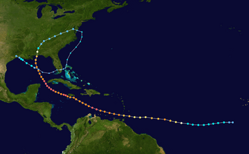
The path of Hurricane Ivan
|
|
| Formed | September 2, 2004 |
|---|---|
| Dissipated | September 24, 2004 |
| Highest winds | 1-minute sustained: 165 mph (270 km/h) |
| Lowest pressure | 910 mbar (hPa); 26.87 inHg |
| Areas affected | Windward Islands (especially Grenada), Venezuela, Jamaica, Grand Cayman, Cuba, Alabama, Florida, and most of the eastern United States, (after rebirth) Texas, Louisiana |
| Part of the 2004 Atlantic hurricane season | |
Hurricane Ivan was a very powerful and long-lasting storm. It was the longest-tracked tropical cyclone during the 2004 Atlantic hurricane season. Ivan started as a tropical wave off the coast of Africa on August 31. It grew stronger as it moved west across the Atlantic Ocean. By September 2, it became Tropical Depression Nine. Ivan quickly became a Category 4 hurricane by September 5. At that time, it was the strongest hurricane ever recorded so far south in the Atlantic.
Ivan briefly weakened due to dry air. But it soon got stronger again. On September 7, it passed just south of Grenada as a major hurricane. Ivan became a Category 5 hurricane in the central Caribbean Sea. Over the next few days, its strength changed as its eye changed shape. Ivan passed just south of Jamaica, the Cayman Islands, and western Cuba. Its winds were at or near Category 5 strength.
As Ivan turned north, it slowly weakened. It made landfall near Gulf Shores, Alabama on September 16. Its winds were about 120 mph (195 km/h). The storm quickly weakened to a tropical depression. It then changed into an extratropical cyclone on September 18.
The leftover parts of Ivan moved south and southwest. After crossing Florida on September 21, it started to become a tropical storm again. It became a tropical depression on September 22, southeast of Louisiana. Ivan reached winds of 60 mph (95 km/h). It then weakened and moved ashore in southwestern Louisiana as a tropical depression. Ivan finally disappeared after moving into Texas on September 25. This storm broke several records for its strength and how long it lasted.
Contents
How Ivan Formed and Grew Strong
On August 31, a large tropical wave moved off the west coast of Africa. This system had a low pressure area and strong winds blowing outwards. But at first, its rain clouds were not organized. By September 1, a large circular wind pattern was seen on satellite images. This was southeast of the Cape Verde Islands. Weather models predicted it would grow stronger. As it moved west, the clouds organized into rainbands. These are spiral bands of showers and thunderstorms. On September 2, the system became Tropical Depression Nine. This was about 450 miles (730 km) southwest of Praia, Cape Verde.
After becoming a tropical cyclone, the depression moved west. It was pushed by strong easterly winds from a high-pressure area to its north. The ocean water was warm, over 82 °F (28 °C). Forecasters expected the storm to slowly get stronger. They thought it would become a hurricane within four days. Some models even predicted it would reach Category 4 strength.
At first, winds from the northeast pushed the center of the storm. But despite this, the depression grew stronger. Early on September 3, it became a tropical storm. The National Hurricane Center named it Tropical Storm Ivan.
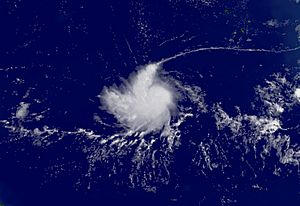
Tropical Storm Ivan slowly became more organized as the winds calmed down. Its strong winds spread out in all directions. Satellite images on September 3 showed a clear band of clouds wrapping around its center. The next day, the storm's clouds became messy for a short time. But then they reorganized and an eye started to form. The storm's clouds grew stronger as the eye became clearer. Ivan became a hurricane around 0600 UTC on September 5.
After becoming a hurricane, Ivan quickly grew much stronger. This happened because conditions were still good. In just 18 hours, its pressure dropped a lot. Its winds increased by 60 mph (95 km/h). Early on September 6, Ivan reached its first peak strength. Its winds were 135 mph (215 km/h). This was about 825 miles (1330 km) east of Tobago.
While Ivan was a major hurricane, its center had very strong clouds and a clear eye. Forecasters thought it was very likely to get even stronger. They predicted Ivan would pass near Barbados with winds of about 150 mph (240 km/h). But soon after becoming a Category 4 hurricane, its outer clouds became messy. Hurricane Hunters found dry air in the northern part of the eye. This caused the eyewall to break down, and winds dropped. By late on September 6, Ivan weakened to 105 mph (165 km/h) winds.
The inner eyewall disappeared. A new, larger outer eyewall, about 23 miles (37 km) wide, took over. At the same time, the hurricane became more organized overall. Ivan then became a major hurricane again as it got closer to the Lesser Antilles. At 2130 UTC on September 7, the storm passed 7 miles (11 km) south-southwest of Grenada. This was its closest point to the island. At that time, the hurricane's eye was 12 miles (19 km) wide. The northern part of its eyewall brought strong winds to Grenada.
Ivan's Journey Through the Caribbean Sea
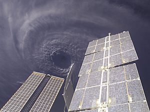
Hurricane Ivan reached Category 4 strength again as it entered the Caribbean Sea. It then went through another eyewall replacement cycle. For about 18 hours, its strength stayed the same. It moved parallel to the northern coast of Venezuela. Another period of rapid strengthening began late on September 8. The storm's path turned to the west-northwest.
Hurricane Hunters flew into the storm. They recorded winds of 180 mph (290 km/h) north and northeast of the eye. A special device called a dropsonde measured winds of 200 mph (325 km/h) above the surface. Based on these reports, Ivan became a Category 5 hurricane at 0600 UTC on September 9. This was about 90 miles (145 km) north of Aruba. At that time, forecasters thought the storm would hit southern Florida as a major hurricane.
After staying at Category 5 strength for about 12 hours, Ivan started to weaken. This was due to another eyewall replacement cycle. Its winds dropped to 140 mph (225 km/h) on September 10. Early the next day, the hurricane reorganized. Its winds were just below Category 5 strength. However, the storm weakened again because of another eyewall replacement cycle.
At 0330 UTC on September 11, Ivan passed 23 miles (37 km) south of Portland Point, Jamaica. This was its closest point to the island. Its winds were 150 mph (240 km/h). Forecasters had thought it would hit Jamaica directly. But the weakening and a turn to the west kept the strongest winds offshore. This last-minute turn was due to a high-pressure system over the eastern Gulf of Mexico.
Ivan continued to weaken slightly. This was because an upper-level low over the Bahamas disrupted its northern winds. As it moved further from Jamaica, Ivan quickly became a Category 5 hurricane again. Early on September 12, it reached its strongest point. Its winds were 165 mph (265 km/h) and its pressure was 910 mbar.
Soon after reaching its peak strength, the hurricane weakened again. It was going through another eyewall replacement cycle. At 1415 UTC on September 12, Ivan passed 25 miles (40 km) south-southwest of George Town, Cayman Islands. Its winds were 150 mph (240 km/h). After its eyewall reformed, Ivan reached Category 5 status for a third time early on September 13.
Soon after, a weather system caused a weak spot in the high-pressure area to its north. This made the hurricane turn to the northwest. The strong winds from this weather system and very warm ocean waters helped Ivan stay at Category 5 strength for 30 hours. Early on September 14, the hurricane passed through the Yucatán Channel. It was about 17 miles (28 km) southwest of Cabo San Antonio, Cuba. The eastern part of its eyewall crossed the western part of Cuba.
Ivan's Landfall in Alabama
After entering the southern Gulf of Mexico, Hurricane Ivan weakened to Category 4 strength by 0600 UTC on September 14. As it slowly turned north, winds from a large weather system over the central United States increased. This caused more wind shear over the hurricane. An eyewall replacement cycle, along with dry air, also made it weaker.
By late on September 14, the weakening stopped as the eyewall became clearer. Ivan was expected to get a little stronger over warmer waters. The eye grew to 60 miles (95 km/h) wide. But strong westerly winds and dry air continued to increase. As Ivan got closer to the Gulf Coast of the United States, Hurricane Hunters reported that the southern part of the eyewall was breaking down. Cooler waters just offshore also made it weaker.
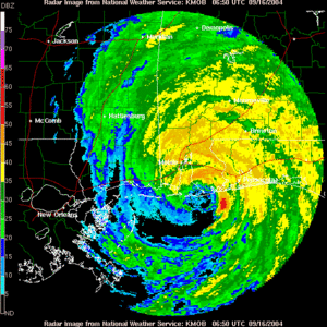
Around 0650 UTC on September 16, Hurricane Ivan made landfall just west of Gulf Shores, Alabama. Its winds were 120 mph (195 km/h). The strongest winds hit a small area near the border of southern Alabama and western Florida.
After moving ashore, the National Hurricane Center thought Ivan would stop moving. They predicted it would stay in the southern Appalachian Mountains before disappearing. As the hurricane crossed Mobile Bay, it turned to the north-northeast. Within twelve hours, Ivan quickly weakened to a tropical storm. Its circulation became less clear. Early on September 17, the storm weakened into a tropical depression over northeastern Alabama. Ivan then sped up to the northeast ahead of a cold front. It dropped heavy rain along its path. Late on September 18, the leftover parts of Ivan became an extratropical low. It merged with the cold front over the Delmarva Peninsula.
Ivan's Return and End
After becoming an extratropical low, the leftover parts of Ivan turned southeast. They moved into the Atlantic Ocean. This happened because a high-pressure area was building to its east. Even as an extratropical cyclone, Ivan could still be seen in weather data. The system turned south and southwest over the next few days.
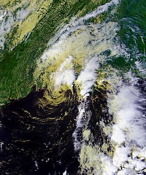
By September 20, the system was off the east coast of Florida. It caused scattered thunderstorms. Strong winds stopped it from becoming a tropical storm again. But forecasters thought conditions might get better later. On September 21, the low crossed southern Florida and moved into the Gulf of Mexico. As it moved over the warm waters, it started to become a tropical storm again. The low-level circulation became clearer, and clouds reformed over the center. Based on reports from Hurricane Hunters, the low became Tropical Depression Ivan again late on September 22. This was about 175 miles (280 km) south-southeast of the mouth of the Mississippi River.
The National Hurricane Center officially called the system Ivan again. This was after a lot of discussion about whether it was truly a new storm or the old one returning. Despite strong winds and messy clouds, the storm strengthened to tropical storm status early on September 23. This was based on Hurricane Hunter reports. As a strong area of clouds formed over the center, Ivan reached winds of 60 mph (95 km/h). But the winds then decreased as the thunderstorms lessened. Ivan weakened to a tropical depression at 0000 UTC on September 24. Two hours later, it moved ashore near Holly Beach, Louisiana.
At first, computer models predicted the storm would turn southwest. They thought it would move back into the Gulf of Mexico. However, the storm quickly weakened over land. By 1200 UTC on September 24, Ivan became just a leftover low-pressure area over southeastern Texas. The low turned south, and the circulation disappeared early on September 25. The leftover weather system reached the northwestern Gulf of Mexico later that day. It caused scattered thunderstorms for a short time before it faded away completely.
Ivan's Amazing Records
Ivan became the southernmost major hurricane ever recorded. It reached Category 3 strength at 10.2° N latitude. Also, Ivan reached Category 4 and Category 5 strength further south than any other Atlantic hurricane. At the time, Ivan was the sixth strongest Atlantic hurricane ever. Now, it is the tenth strongest.
Throughout its life, Ivan kept major hurricane strength or higher for a total of 10 days. This set a new record for Atlantic hurricanes. Ivan lasted as a tropical cyclone for a total of 450 hours. This makes it the tenth longest-tracked Atlantic hurricane ever. After its first landfall in the United States, the hurricane caused 117 tornadoes. This is the largest tornado outbreak ever caused by a tropical cyclone. It broke the old record of 115 tornadoes set by Hurricane Beulah in 1967.
Related pages


