
Tarapacá Region facts for kids
Quick facts for kids
Tarapacá Region
Región de Tarapacá
|
|||
|---|---|---|---|
 |
|||
|
|||

Map of Tarapacá Region
|
|||
| Country | |||
| Capital | Iquique | ||
| Provinces | Iquique, Tamarugal | ||
| Area | |||
| • Total | 41,799.5 km2 (16,138.9 sq mi) | ||
| Area rank | 6 | ||
| Lowest elevation | 0 m (0 ft) | ||
| Population | |||
| • Total | 324,930 | ||
| • Rank | 12 | ||
| • Density | 7.77354/km2 (20.1334/sq mi) | ||
| ISO 3166 code | CL-TA | ||
| Website | Official website: http://www.intendenciatarapaca.gov.cl/ | ||


The Tarapacá Region (called I Región de Tarapacá in Spanish) is one of Chile's 16 main areas, like a state or province. It is located in the northern part of Chile. This region was created in 2007 when the older Tarapacá Region was split into two. This change officially happened on October 8, 2007.
The city of Iquique is the capital of the Tarapacá Region. It is a very important port city.
Contents
A Look Back in Time
The land that is now the Tarapacá Region used to be a part of Peru. Chile took control of it after a big conflict called the War of the Pacific in 1883. Later, in 1929, it officially became part of Chile through a special agreement called the Treaty of Lima.
This region was once very important for its economy. Many people worked in saltpeter mines here. Saltpeter was used to make things like fertilizer and explosives. However, after people learned how to make nitrate in factories, the mining became less important.
Where is Tarapacá?
The Tarapacá Region is located in the northern part of Chile. To the north, it borders the Arica and Parinacota region. To the east, it shares a border with Bolivia's Oruro Department. The Antofagasta region is to the south. To the west, the region meets the Pacific Ocean.
 |
Arica and Parinacota region | |
||
| Pacific Ocean | Oruro (Bolivia) | |||
| Antofagasta region |
People Living in Tarapacá
As of 2015, about 336,769 people were estimated to be living in the Tarapacá Region. This means there were about 8 inhabitants for every square kilometer.
The largest city in the region is Iquique. According to a 2002 count, about 164,396 people lived in Iquique.
How the Region is Organized
In 2007, the old Tarapacá region was divided into two new regions. The Arica y Parinacota Region was created to the north. The current Tarapacá Region was formed to the south.
The Tarapacá Region is further divided into two smaller areas called provinces. These are Iquique and Tamarugal. Each province is then divided into even smaller areas called comunas.
| Province | Capital | Code | Comuna | Area (km²) |
Population (2002) |
|---|---|---|---|---|---|
| Iquique (011) | Iquique | 01101 | 2 Iquique | 2,242.1 | 166,204 |
| 01102 | 1 Alto Hospicio | 593.2 | 50,215 | ||
| Total of Iquique province | 2,835.3 | 216,419 | |||
| Tamarugal (014) | Pozo Almonte | ||||
| 01401 | 7 Pozo Almonte | 13,765.8 | 10,830 | ||
| 01402 | 3 Camiña | 2,200.2 | 1,275 | ||
| 01403 | 4 Colchane | 4,015.6 | 1,649 | ||
| 01404 | 5 Huara | 10,474.6 | 2,599 | ||
| 01405 | 6 Pica | 8,934.3 | 6,178 | ||
| Total of Tamarugal province | 39,390.5 | 22,531 | |||
| Total of the region | 42,225.8 | 238,950 | |||
Images for kids
-
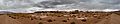
Landscape near Collahuasi, Tarapacá.
-
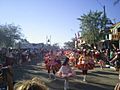
Dancers in the Fiesta de La Tirana, the main religious festival in northern Chile
-
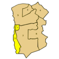
Map showing the comunas (municipalities) of Tarapacá.


Related pages
| Regions of Chile | |
|---|---|
| Arica y Parinacota | Tarapacá | Antofagasta | Atacama | Coquimbo | Valparaíso | O'Higgins | Maule | Bío Bío | La Araucanía | Los Ríos | Los Lagos | Aysén | Magallanes y la Antártica Chilena | RM Santiago | |
See also
 In Spanish: Región de Tarapacá para niños
