Aitkin County, Minnesota facts for kids
Quick facts for kids
Aitkin County
|
|
|---|---|

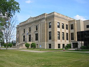
Aitkin County Courthouse
|
|

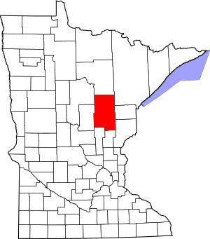
Location within the U.S. state of Minnesota
|
|
 Minnesota's location within the U.S. |
|
| Country | |
| State | |
| Founded | May 23, 1857 (created) June 30, 1871 (organized) |
| Named for | William Alexander Aitken |
| Seat | Aitkin |
| Largest city | Aitkin |
| Area | |
| • Total | 1,995 sq mi (5,170 km2) |
| • Land | 1,822 sq mi (4,720 km2) |
| • Water | 174 sq mi (450 km2) 8.7%% |
| Population
(2020)
|
|
| • Total | 15,697 |
| • Estimate
(2023)
|
16,102 |
| • Density | 8.69/sq mi (3.36/km2) |
| Time zone | UTC−6 (Central) |
| • Summer (DST) | UTC−5 (CDT) |
| Congressional district | 8th |
Aitkin County (/ˈeɪkɪn/ AY-kin) is a county in the U.S. state of Minnesota. It's located in the central part of the state. As of the 2020 census, about 15,697 people lived there.
The main town and county seat is Aitkin. A part of the Mille Lacs Indian Reservation is also within the county. Aitkin County was first created in 1857 and officially organized in 1871.
Contents
History
Aitkin County started in 1857. It was first called Aiken County. The spelling changed to its current form, Aitkin, in 1872.
The county was named after William Alexander Aitken. He was a fur trader who worked for the American Fur Company. This company was led by John Jacob Astor. The county was formed from parts of Ramsey and Pine counties.
Geography
Aitkin County is a place with many trees and rolling hills. You'll also find lots of lakes and ponds here. The famous Mississippi River flows through the western-central part of the county, heading south.
The land generally slopes downwards towards the south. The highest point is Quadna Mountain, which is about 1,591 feet (485 meters) above sea level. It's located near Hill City. The county covers a total area of about 1,995 square miles (5,167 km²). Most of this area is land, with about 174 square miles (451 km²) being water.
Major roads
These are the main highways that go through Aitkin County:
Neighboring counties
Aitkin County shares borders with these other counties:
- Itasca County - to the north
- Saint Louis County - to the northeast
- Carlton County - to the east
- Pine County - to the southeast
- Kanabec County - to the south
- Mille Lacs County - to the southwest
- Crow Wing County - to the west
- Cass County - to the northwest
Protected natural areas
Aitkin County has several protected natural areas. These places help keep nature safe and healthy.
- Grayling State Wildlife Management Area
- Hill River State Forest
- Kimberly State Wildlife Management Area
- McGregor Marsh Scientific and Natural Area
- Rice Lake National Wildlife Refuge
- Ripple River State Wildlife Management Area
- Salo Marsh State Wildlife Management Area
- Savanna Portage State Park
- Snake River County Park
- Solana State Forest
Climate and weather
| Weather chart for Aitkin, Minnesota | |||||||||||||||||||||||||||||||||||||||||||||||
|---|---|---|---|---|---|---|---|---|---|---|---|---|---|---|---|---|---|---|---|---|---|---|---|---|---|---|---|---|---|---|---|---|---|---|---|---|---|---|---|---|---|---|---|---|---|---|---|
| J | F | M | A | M | J | J | A | S | O | N | D | ||||||||||||||||||||||||||||||||||||
|
1
20
0
|
0.8
26
4
|
1.7
38
16
|
2.6
54
30
|
3.1
66
40
|
4.5
75
51
|
4.2
80
56
|
3.2
77
53
|
3.3
68
45
|
2.9
55
34
|
1.6
38
21
|
1
24
7
|
||||||||||||||||||||||||||||||||||||
| temperatures in °F precipitation totals in inches source: The Weather Channel |
|||||||||||||||||||||||||||||||||||||||||||||||
|
Metric conversion
|
|||||||||||||||||||||||||||||||||||||||||||||||
The weather in Aitkin County changes a lot with the seasons. In the county seat of Aitkin, average temperatures in January are around 0°F (-18°C). In July, they can reach about 80°F (27°C).
The coldest temperature ever recorded was -47°F (-44°C) in January 1972. The hottest was 100°F (38°C) in August 1976. The amount of rain and snow also changes throughout the year. June usually gets the most precipitation, while February gets the least.
People and population
The number of people living in Aitkin County has changed over time. Here's a look at the population from different years:
| Historical population | |||
|---|---|---|---|
| Census | Pop. | %± | |
| 1860 | 2 | — | |
| 1870 | 178 | 8,800.0% | |
| 1880 | 366 | 105.6% | |
| 1890 | 2,462 | 572.7% | |
| 1900 | 6,473 | 162.9% | |
| 1910 | 10,371 | 60.2% | |
| 1920 | 15,043 | 45.0% | |
| 1930 | 15,009 | −0.2% | |
| 1940 | 17,865 | 19.0% | |
| 1950 | 14,327 | −19.8% | |
| 1960 | 12,162 | −15.1% | |
| 1970 | 11,403 | −6.2% | |
| 1980 | 13,404 | 17.5% | |
| 1990 | 12,425 | −7.3% | |
| 2000 | 15,301 | 23.1% | |
| 2010 | 16,202 | 5.9% | |
| 2020 | 15,697 | −3.1% | |
| 2023 (est.) | 16,102 | −0.6% | |
| U.S. Decennial Census 1790-1960 1900-1990 1990-2000 2010-2020 |
|||
2020 Census information
In 2020, the census counted 15,697 people in Aitkin County. Most of the people living there were White.
| Race | Num. | Perc. |
|---|---|---|
| White (Non-Hispanic) | 14,479 | 92.24% |
| Black or African American (Non-Hispanic) | 58 | 0.37% |
| Native American (Non-Hispanic) | 376 | 2.4% |
| Asian (Non-Hispanic) | 38 | 0.24% |
| Pacific Islander (Non-Hispanic) | 1 | 0.01% |
| Other/Mixed (Non-Hispanic) | 525 | 3.34% |
| Hispanic or Latino | 220 | 1.4% |
2010 Census information
In 2010, there were 16,202 people living in Aitkin County. About 95.63% of the people were White. About 2.4% were Native American.
Many people in the county have roots from different countries. The largest groups were of German (29.5%), Norwegian (14.3%), and Swedish (13.0%) backgrounds.
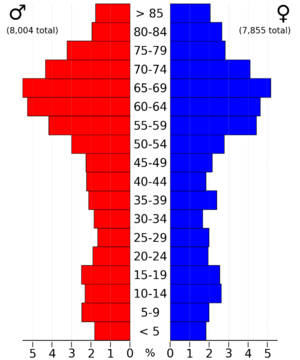
About 20.90% of the people were under 18 years old. About 23.00% were 65 years or older. The average age in the county was 46 years.
Communities
Aitkin County has several towns and smaller communities. These include cities, townships, and other areas.
Cities
Townships
- Aitkin Township
- Ball Bluff Township
- Balsam Township
- Beaver Township
- Clark Township
- Cornish Township
- Farm Island Township
- Fleming Township
- Glen Township
- Haugen Township
- Hazelton Township
- Hill Lake Township
- Idun Township
- Jevne Township
- Kimberly Township
- Lakeside Township
- Lee Township
- Libby Township
- Logan Township
- Macville Township
- Malmo Township
- McGregor Township
- Millward Township
- Morrison Township
- Nordland Township
- Pliny Township
- Rice River Township
- Salo Township
- Seavey Township
- Shamrock Township
- Spalding Township
- Spencer Township
- Turner Township
- Verdon Township
- Wagner Township
- Waukenabo Township
- Wealthwood Township
- White Pine Township
- Williams Township
- Workman Township
Unorganized areas
These are areas that don't have their own local government like cities or townships:
Other small communities
These are smaller places that are not officially cities or townships:
See also
 In Spanish: Condado de Aitkin para niños
 | Aaron Henry |
 | T. R. M. Howard |
 | Jesse Jackson |


