Ball Ground, Georgia facts for kids
Quick facts for kids
Ball Ground, Georgia
|
||
|---|---|---|

Ball Ground Historic District
|
||
|
||

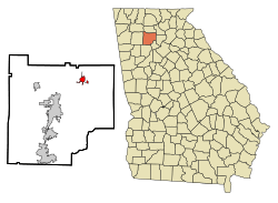
Location in Cherokee County and the state of Georgia
|
||
| Country | United States | |
| State | Georgia | |
| County | Cherokee | |
| Area | ||
| • Total | 6.35 sq mi (16.44 km2) | |
| • Land | 6.31 sq mi (16.34 km2) | |
| • Water | 0.04 sq mi (0.09 km2) | |
| Elevation | 1,102 ft (336 m) | |
| Population
(2020)
|
||
| • Total | 2,560 | |
| • Density | 405.71/sq mi (156.63/km2) | |
| Time zone | UTC-5 (Eastern (EST)) | |
| • Summer (DST) | UTC-4 (EDT) | |
| ZIP code |
30107
|
|
| Area codes | 770/678/470 | |
| FIPS code | 13-05036 | |
| GNIS feature ID | 0354443 | |
Ball Ground is a city in Cherokee County, Georgia, United States. This area was once home to the Cherokee people. Later, it became a place for new settlers. A railroad was built in 1882, and a town grew around this new train stop. The town officially became a city on January 1, 1883.
For a long time, Ball Ground's economy was mostly about its marble industry. But by the mid-1900s, these industries started to leave, and the city's growth slowed down. However, since the year 2000, Ball Ground has grown very quickly! In the 2020 census, the city had 2,560 people. This is more than three times its population of 730 in 2000.
Contents
History of Ball Ground
Early Days and How the Town Started
The land where Ball Ground is today was originally lived in by both the Cherokee and the Muscogee Creek tribes. In 1755, a battle called the Battle of Taliwa happened here between the Cherokee and Muscogee Creek. The Cherokee won, and the Muscogee Creek moved out of the area.
Later, in the 1830s, the Cherokee people were moved out of Cherokee County, including the Ball Ground area. This happened after a law called the Indian Removal Act was passed in 1830. The land was then given to European-American settlers through the 1832 Georgia Land Lotteries. The Cherokee fully left North Georgia after the 1835 Treaty of New Echota. They moved west of the Mississippi River as part of the Cherokee removal.
The name "Ball Ground" came from the Native American people. They used this area as a "ballground" to play a game similar to town ball. Settlers then named the town "Ball Ground" because of this. There are also some interesting local stories about the name. One story says it was named after a game played in 1532 between Native Americans and Hernando de Soto and his men. Another story, told as "local folklore," says the name comes from a stickball game between the Cherokee and Creek tribes. The prize for that game was a thousand square miles of land!
After the 1830s, Ball Ground was mostly farmland with only a few people living there. By 1847, the area had a post office. In 1882, just before the town was officially formed, Ball Ground had six homes and two country stores.
People started talking about building a railroad through Ball Ground in 1875. Work on the railroad began in 1881. The tracks were part of the Marietta and North Georgia Railroad and were finished in 1882. Ball Ground became the end point for this new railroad, with a new depot built there.
A town quickly grew around the Ball Ground depot. Thirteen landowners nearby donated their land to create the town. They believed it would make their surrounding lands more valuable and help the whole area. The donated land was divided into 200 lots and sold at an auction in Ball Ground on April 18, 1883. By 1884, about 300 people lived in the new town.
Becoming an Official Town
Ball Ground officially became a town on September 27, 1883. This happened through a special document called a town charter from the Georgia General Assembly. The town's boundaries were set as "one half mile in every direction from the present railroad crossing on the Gilmer Ferry road."
Over the years, the town's rules and powers changed. In 1911, a new charter gave the city government more power. It allowed them to create local laws and set up a school district within Ball Ground.
In 1961, a group called the Ball Ground Improvement Association was formed. They wanted to make the city better by adding things like new paint, a city park, and street lights.
Bringing Ball Ground Back to Life
In 1971, a TV show called Ball Ground a "city in decline." This made the city's businesses decide to work together. They formed the Ball Ground Merchants Association to help local trade and act like a Chamber of Commerce.
In 1972, the Ball Ground Community Association was created. They wanted to promote the town and organize fun events. Their first event was a spring festival and parade in May 1972. This event was special because it included a group from the Cherokee Nation. It was the first time the Cherokee had officially returned to the area since they were moved in the 1830s. As part of the festival, two Cherokee teams played a game of stickball. The festival was a big success, and Ball Ground won the "1972 Stay & See Georgia" contest. This program helped promote tourism in Georgia. The spring festival happened every year until 1989.
In 1997, new homes and communities started to be built in Ball Ground. Because the city was growing, people realized they needed a better sewer system. This would help old homes and attract even more new growth. A plan for a $2.8 million sewage system was put in place in 1998. The system was finished in the fall of 2003, as more development continued in Ball Ground.
Geography and Climate
Where Ball Ground Is Located
Ball Ground is located at the bottom of the North Georgia mountains. It's in the northeastern part of Cherokee County. The city is about 4.7 miles (7.6 km) northeast of Canton and 0.4 miles (0.64 km) south of Nelson. It's the northernmost city in Cherokee County that is completely within the county. Nelson is partly in Pickens County. Ball Ground is about 37.9 miles (61.0 km) north of Atlanta's northern city limits.
The land in Ball Ground is part of the Upper Piedmont Physiographic Province. The rocks under the city are igneous and metamorphic rocks like gneiss and schist. The area around Ball Ground has a lot of marble deposits. It also has talc, pyrite, and gold.
According to the United States Census Bureau in 2020, Ball Ground covers about 6.3 square miles (16.3 km2). Only a small part, about 0.04 square miles (0.10 km2), is water. The city is about 1,100 feet (335 m) above sea level. It ranges from just over 1,000 feet (305 m) in valleys to about 1,200 feet (366 m) on some hilltops. Unlike many other parts of Cherokee County, Ball Ground is not in a floodplain. This means it usually doesn't have areas that flood often. The city government has rules to protect its water and land. These rules protect stream buffers, watersheds, and wetlands.
Ball Ground's Weather
Ball Ground has a humid subtropical climate, just like most of the southeastern United States. This means it has four seasons. Summers are hot and humid, and winters are cool. July and August are usually the warmest months, with an average high temperature of about 85°F (29°C). January is the coldest month, with an average high of about 48°F (9°C).
Ball Ground gets rain pretty evenly throughout the year. March usually has the most rain, with an average of 5.15 inches (13.1 cm). May is typically the driest month, with about 3.81 inches (9.7 cm) of rain.
| Climate data for Ball Ground, Georgia (1981-2010) | |||||||||||||
|---|---|---|---|---|---|---|---|---|---|---|---|---|---|
| Month | Jan | Feb | Mar | Apr | May | Jun | Jul | Aug | Sep | Oct | Nov | Dec | Year |
| Mean daily maximum °F (°C) | 48 (9) |
53 (12) |
62 (17) |
70 (21) |
76 (24) |
82 (28) |
85 (29) |
85 (29) |
79 (26) |
71 (22) |
61 (16) |
51 (11) |
69 (20) |
| Mean daily minimum °F (°C) | 29 (−2) |
30 (−1) |
37 (3) |
45 (7) |
54 (12) |
62 (17) |
66 (19) |
66 (19) |
59 (15) |
48 (9) |
39 (4) |
31 (−1) |
47 (8) |
| Average precipitation inches (mm) | 5.14 (131) |
5.01 (127) |
5.15 (131) |
4.00 (102) |
3.81 (97) |
4.22 (107) |
4.70 (119) |
4.61 (117) |
4.67 (119) |
4.07 (103) |
4.28 (109) |
4.45 (113) |
54.11 (1,375) |
| Source: US Climate Data | |||||||||||||
People and Population
| Historical population | |||
|---|---|---|---|
| Census | Pop. | %± | |
| 1890 | 296 | — | |
| 1900 | 302 | 2.0% | |
| 1910 | 443 | 46.7% | |
| 1920 | 809 | 82.6% | |
| 1930 | 706 | −12.7% | |
| 1940 | 711 | 0.7% | |
| 1950 | 700 | −1.5% | |
| 1960 | 707 | 1.0% | |
| 1970 | 617 | −12.7% | |
| 1980 | 640 | 3.7% | |
| 1990 | 905 | 41.4% | |
| 2000 | 730 | −19.3% | |
| 2010 | 1,433 | 96.3% | |
| 2020 | 2,560 | 78.6% | |
| 2023 (est.) | 3,039 | 112.1% | |
| U.S. Decennial Census | |||
The 2000 United States census showed that Ball Ground's population had gone down. It dropped from 905 people in 1990 to 730 in 2000. But after improvements to the sewer system and new homes and businesses were built in the 2000s, the city started to grow a lot. By the 2010 census, the population had jumped by 96.3% to 1,433 people. In 2020, it grew another 78.6% to 2,560 people.
As of the 2020 United States census, there were 2,560 people living in Ball Ground. There were 838 households and 626 families. The population density was about 406 people per square mile (157 per km2).
The 2020 American Community Survey showed that 33.8% of households had children under 18 living with them. About 67.1% were married couples. The average household had 2.66 people, and the average family had 3.03 people.
The population in the city was spread out by age:
- 22.7% were under 18 years old.
- 6.8% were from 18 to 24.
- 27.3% were from 25 to 44.
- 32.2% were from 45 to 64.
- 11.1% were 65 years or older.
The average age was 38.4 years.
The median income for a household in Ball Ground was $81,900. For a family, the median income was $92,690. About 4% of the population lived below the poverty line. This included 6.2% of those under 18 and 0.8% of those 65 or older.
| Race | Num. | Perc. |
|---|---|---|
| White (non-Hispanic) | 2,300 | 89.84% |
| Black or African American (non-Hispanic) | 21 | 0.82% |
| Native American | 7 | 0.27% |
| Asian | 6 | 0.23% |
| Other/Mixed | 104 | 4.06% |
| Hispanic or Latino | 122 | 4.77% |
Economy and Jobs
When Ball Ground was first created, its economy relied a lot on farming and the railroad. The railroad brought marble from Tate, Georgia to be processed in Ball Ground. In the early 1900s, the city had a ginery (for cotton), a saw mill, and a marble mill. The marble industry became a huge part of Ball Ground's economy. By the 1920s, there were four marble finishing mills in the city. However, by 1959, most of the marble industry and other farming industries had either closed down or moved away from Ball Ground.
Some big companies used to have plants in Ball Ground. The Coca-Cola Company opened a bottling plant here in 1903. It operated for 30 years, closing in 1933. Tyson Foods had a feed mill in Ball Ground from 1965 to 1998. They then moved to a larger facility in Bartow County.
The city has an industrial area called the River Mill Industrial Park. It's a 100-acre (40 ha) area with access to the railroad.
In May 2015, Universal Alloy Corporation (UAC) announced they would build a new factory in Ball Ground. This factory would make parts for Boeing aircraft wings. UAC is one of the largest employers in Cherokee County. They finished their 110,000 square foot (10,000 m2) Ball Ground factory in 2017. UAC employs over 500 people.
Fun Things to Do and See
Arts and Culture
The Sequoyah Regional Library System has a branch in Ball Ground called the Ball Ground Library. It's a 9,000 square foot (840 m2) building with about 30,000 books.
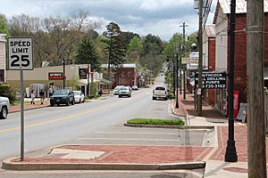
In 1985, the Alfred W. Roberts House was added to the National Register of Historic Places. It's the only house in Cherokee County with this special recognition. In 2009, the Ball Ground Historic District was also listed on the NRHP. This was because of its importance to Native American and early national history. Many homes in Ball Ground built between the 1880s and 1920s are considered historic. In 2010, Ball Ground created a historic preservation commission. This group helps protect and care for historic buildings and objects in the city.
Yearly Events
Since 2014, Ball Ground has held an annual Christmas parade called the March of the Toys Parade. This parade helps collect toys for the Toys for Tots program. In 2017, about 5,000 people attended the event. They were asked to bring unwrapped presents to donate.
In the summers, Ball Ground's City Park hosts weekly movies and concerts. During Independence Day celebrations, the city has annual fireworks shows. These shows happen around City Park and Calvin Farmer Park in downtown Ball Ground.
Parks and Recreation
Ball Ground has several parks and places for fun activities. These are managed by the city's parks and recreation department. They include a 15-acre (6.1 ha) park, baseball fields, tennis courts, basketball courts, ponds, open fields, and wooded areas. Some parks also have walking trails and places for fishing.
There are two botanical gardens in Ball Ground. Ball Ground Botanical Gardens is a free 0.75-acre (0.30 ha) garden with a butterfly-shaped walking trail. Gibbs Gardens is a much larger property, over 300 acres (120 ha). It has sixteen different gardens, including ponds, bridges, and waterfalls. In 2020, Business Jet Traveler magazine ranked Gibbs Gardens #2 on its list of "13 best U.S. botanical gardens." Gibbs Gardens is famous for its over 20 million daffodils that bloom in the spring.
Just outside Ball Ground's city limits, about 1.9 miles (3.1 km) away, is the McGraw Ford Wildlife Management Area. This is a 2,255-acre (913 ha) wildlife management area along the Etowah River. It's managed by the Georgia Department of Natural Resources. It has many trails for different uses, plus areas for fishing and hunting.
Education for Students
Public schools in Ball Ground are managed by the Cherokee County School District. Students living in the city attend Ball Ground Elementary School, Creekland Middle School, and Creekview High School. High school students in Ball Ground can also choose to attend Mountain Education Charter High School (MECHS). This is an alternative school program that offers evening classes to help students earn a high school diploma. While MECHS has many campuses, the Cherokee County classes are held at the Etowah High School campus in Woodstock, Georgia.
TLE Christian Academy at Gospel Outreach Inc is the only private school in Ball Ground. It's a private school for students from kindergarten to 12th grade. In 2021, it had 30 students.
The closest college or university to Ball Ground is Reinhardt University in Waleska, Georgia. It's about 12.1 miles (19.5 km) from Ball Ground.
Media and News
Since Ball Ground is in the North Georgia area, its main TV stations are:
- WXIA-TV (NBC)
- WANF (CBS)
- WSB-TV (ABC)
- WAGA-TV (Fox)
WGTV is the local station for the statewide Georgia Public Television network. It is a PBS member station.
The city gets news from the Atlanta Journal-Constitution, which covers the Atlanta area and all of Cherokee County. It also gets news from the Cherokee Tribune & Ledger-News, which is the official newspaper for Cherokee County.
City Services
Getting Around Ball Ground
Interstate 575 goes through Ball Ground from southwest to northeast. Exit 27 on I-575 is in Ball Ground and leads to Howell Bridge Road. This exit is the last northbound exit on I-575 before the interstate ends. Parts of Howell Bridge Road are also called State Route 5 Business. This road goes through the city from west to east and crosses Georgia State Route 5 (also known as Ball Ground Highway). State Route 5 runs next to Interstate 575 in the city, going in a similar southwest-to-northeast direction. Georgia State Route 372 (also called Ball Ground Road, Gilmer Ferry Road, and A W Roberts Drive within the city) comes into Ball Ground from the southeast. It goes through the center of town before joining State Route 5/Ball Ground Highway to leave the city to the north.
The closest airport is the Cherokee County Regional Airport. It's a small public airport with one paved runway. It's located about 5.2 miles (8.4 km) from downtown Ball Ground, between Ball Ground and Canton. The closest major airport is Hartsfield–Jackson Atlanta International Airport, which is about 58.3 miles (93.8 km) from Ball Ground. The Georgia Northeastern Railroad is a freight rail line that runs through Ball Ground and has a stop there. This stop is a special team track within the city.
City Utilities
Ball Ground's water department manages the city's water supply using a system of pumped wells. Sewage treatment in the city is also handled by the city government. Trash collection is managed by Waste Management, a private company that works with the city.
Well-Known People from Ball Ground
- Keith R. Blackwell, a former Associate Justice of the Supreme Court of Georgia
- Russ Lyon, a professional baseball player
- Garland F. Pinholster, a coach at Oglethorpe University and a Georgia State legislator
See also
 In Spanish: Ball Ground para niños
 | Sharif Bey |
 | Hale Woodruff |
 | Richmond Barthé |
 | Purvis Young |


