Black Butte (Oregon) facts for kids
Quick facts for kids Black Butte |
|
|---|---|
 |
|
| Highest point | |
| Elevation | 6,436 ft (1,962 m) NAVD 88 |
| Prominence | 3,076 ft (938 m) |
| Geography | |
| Parent range | Cascade Range |
| Topo map | USGS Black Butte |
| Geology | |
| Age of rock | Pleistocene |
| Mountain type | Mafic volcano |
| Volcanic arc | Cascade Volcanic Arc |
| Last eruption | About 1,430,000 years ago |
| Climbing | |
| Easiest route | Hike |
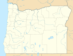
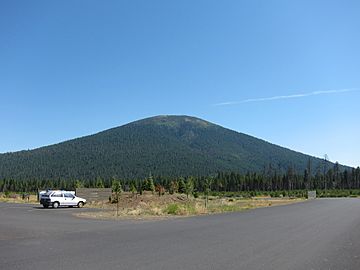
Black Butte is an extinct volcano in Oregon, a state in the U.S.. It is located in Jefferson County. This mountain is part of the Deschutes National Forest. Black Butte is also part of the Cascade volcanic arc.
The butte sits just south of the Metolius Springs. These springs come together to form the start of the Metolius River. The area around the Metolius River is home to many plants and animals. You can find large and small mammals there. More than 80 types of birds also live in this region.
Black Butte last erupted a very long time ago. Geologists think it was about 1.43 million years ago. The volcano is made of basaltic andesite lava. This type of rock is rich in magnesium and iron. Black Butte has a clear, even shape. It looks well-preserved even though it has some erosion. You can see shallow ravines and deep gullies on its sides. There are also smaller volcanoes called cinder cones nearby.
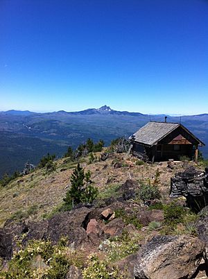
There used to be a building for spotting fires on the butte. The United States Forest Service removed it in 2016. Today, a white dome-like structure and a modern fire lookout tower are on top. A nearby community called Black Butte Ranch offers many fun activities. These include horseback riding, biking, hiking, and canoeing. In winter, people enjoy Nordic skiing and snowshoeing.
Contents
Where is Black Butte Mountain?
Black Butte is about 21 miles (34 km) southeast of Mount Jefferson. It is also about 8.6 miles (14 km) northwest of where U.S. Route 126 and U.S. Route 20 meet. This mountain is on the eastern edge of Sisters. Black Butte is in Jefferson County, Oregon. Other volcanoes like Three Fingered Jack are about 10 miles (16 km) to the west.
Scientists have measured Black Butte's height. The U.S. National Geodetic Survey says it is 6,436 feet (1,962 meters) tall. Other sources give slightly different numbers. Black Butte is a very noticeable mountain. It stands out in the Deschutes Valley. This is because of its dark color and even shape.
Black Butte is part of the Cascade Volcanic Arc. This arc is in the northwestern United States. The mountain is in a "rain shadow." This means it gets less rain than areas to the west.
The Metolius River Springs
Black Butte is just south of the Metolius Springs. These springs are in the southwest part of Jefferson County. You can reach them from roads off U.S. Route 20. The springs are about 30 miles (48 km) northwest of Bend and Redmond.
Black Butte rises above the Metolius Valley. This valley is about 3 miles (5 km) wide. Its elevation is about 3,000 feet (910 meters) above sea level. At the northern base of the volcano, two openings create the Metolius Springs. The water bubbles out at 48 degrees Fahrenheit (9 degrees Celsius). These springs combine to form the start of the Metolius River. They produce a lot of water each year.
The river flows for 35 miles (56 km) north and east. It then joins the Deschutes River. Other springs and small rivers add more water along the way. Long ago, glaciers caused erosion. This erosion spread sand, gravel, and volcanic ash across the Metolius Valley floor.
Black Butte's eruptions changed the old Metolius River. They left large rocks of lava in the area. The volcano's formation also blocked some water paths. This divided the Metolius Valley. One part is where the river now flows. The other part includes Black Butte Swamp and Glaze Meadow. These areas were likely shallow lakes before. Now, they collect water from streams and drainages. Black Butte Swamp is very important for collecting water. It helps keep the Metolius Springs flowing steadily.
Nature Around Black Butte
Black Butte is east of the main Cascade mountains. This area is drier than the western Cascades. Scientists studied the forests at Black Butte in 1975. They looked at ponderosa pine trees and grand and white fir trees. The study found that trees at Black Butte did not suffer much from lack of water.
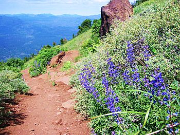
The forest along the Black Butte trail is very diverse. You can see yellow-bellied ponderosa pines. There are also mixed conifers and subalpine plants.
Black Butte is part of the Deschutes National Forest. This forest covers about 1.6 million acres (6,500 km²) in central Oregon. It is also part of the Metolius Black Butte Scenic area. This area is about 10,600 acres (43 km²) and is home to northern goshawks.
The Metolius River flows through old-growth forests. These include ponderosa pine, Douglas fir, and western larch trees. In May, many native plants and wildflowers bloom. These include early blue violets, larkspur, and serviceberry. In summer, you can see arrowleaf balsamroot and bigleaf lupine. A rare wildflower called Penstemon peckii grows here. It is special because it comes in 7 different colors.
More than 80 types of birds live in the Metolius Preserve. One example is the white-headed woodpecker. Many large mammals also live here. These include American black bears, deer, cougars, and elk. Smaller mammals like northern flying squirrels and shrews are also present.
How Black Butte Formed
The Oregon part of the Cascade Volcanoes has many volcanoes. There are over 1,000 volcanoes that formed in the last 2.6 million years. These volcanoes are very close together. Rocks in the Metolius Springs area are from the High Cascades. They include volcanic rocks and deposits from glaciers.
Black Butte is on the edge of the Sisters fault zone. This zone has about 50 known faults. It stretches southeast through Sisters and Bend. Black Butte itself sits on a small fault. Its lava has moved slightly because of a fault on its northwest side. To the north is the Green Ridge fault scarp. This is a steep slope that rises about 2,000 feet (610 meters) above the Metolius Valley.
Most volcanoes in the Oregon Cascades are small. They are often scoria cones or small shield volcanoes. Black Butte is a stratovolcano, also called a composite volcano. It is made of mafic rock, which is rich in magnesium and iron. Black Butte is an extinct volcano.
The cone of Black Butte rises 3,076 feet (938 meters) above the land around it. It is a striking sight near US Highway 20. Black Butte looks young and symmetrical. But it is actually older than many other volcanoes in the High Cascades. It has not been changed much by glaciers. Black Butte has some mild erosion. It has shallow ravines and deep gullies on its sides. The volcano has a steep-sided volcanic cone. It does not have a summit crater. Black Butte is one of the larger mafic volcanic cones in Oregon. It has a volume of about 10 cubic kilometers.
Nearby Volcanic Features
The Sixmile Butte lava field is from the Pleistocene age. It has ten cinder cones between Black Butte and Black Crater. These cones erupted basaltic andesite lava. This lava was laid down before glaciers moved into the Suttle Lake area. The field covers about 25 square miles (65 km²). There are also other cinder cones nearby. Some are to the east and some to the south of Black Butte.
Black Butte's Past
Scientists used a method called potassium–argon dating to study Black Butte. They found that samples from the volcano are about 1.43 million years old. This means Black Butte formed a very long time ago.
Large block faulting near the Metolius Springs might have happened when volcanoes started forming in the High Cascades. These eruptions built Black Butte. We don't know exactly how long these eruptions lasted. The molten rock for Black Butte likely came up through the Green Ridge fault.
Scientists have found old lava deposits from Black Butte. These deposits are older than 0.78 million years. They are made of basaltic andesite lava. This lava has small crystals of plagioclase and olivine. The last known eruption of Black Butte was during the Pleistocene. However, some volcanic activity has continued in the High Cascades. For example, a lava flow near McKenzie Pass is only 1,500 years old.
Human History and Recreation
Black Butte was a well-known landmark for Native Americans. There is a traditional story about the butte. It was told by Native Americans living on the Warm Springs Reservation. The story says that the mountains of Central Oregon were once people. Black Butte was the wife of nearby Green Ridge.
It is not known who gave Black Butte its modern name. But settlers were calling it Black Butte as early as 1855. An engineer named Lieutenant H. L. Abbot also used the name Black Butte in his reports.
The butte has been used for fire detection since 1910. A fire lookout building was built in 1979. Fire lookout staff used it for cooking and sleeping. It was removed in 2016 by the United States Forest Service. Lookouts still work at Black Butte during fire season. They use a yurt (a type of portable tent) instead. A white dome structure has been on the butte since 1923. A modern fire lookout tower, 62 feet (19 meters) tall, was built in 1995. Visitors cannot go inside these structures.
Fun Things to Do at Black Butte
The land around Black Butte and the Metolius Springs is managed by the United States Forest Service. They have built a parking lot, a trail, and a viewpoint. There are also famous fishing resorts and a popular recreation area nearby.
Black Butte Ranch is a resort community. It covers 1,800 acres (7.3 km²) in the Deschutes National Forest. It offers many fun activities. You can go horseback riding, biking, hiking, canoeing, kayaking, and paddleboarding. In winter, you can enjoy Nordic skiing and snowshoeing.
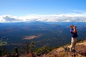
The Black Butte hiking trail is about 2 miles (3.2 km) long. It goes from a trailhead up the butte. The trees become thinner in the second mile of the hike. The trailhead is very busy in the summer. Many cars and hikers come to visit. The hiking trail itself is only for hikers. The hike is popular and not too hard. It climbs about 1,600 feet (490 meters) to the top. From the peak, you can see Three Sisters, Mount Washington, and Mount Jefferson.
See also
 In Spanish: Black Butte para niños
 | Bessie Coleman |
 | Spann Watson |
 | Jill E. Brown |
 | Sherman W. White |


