Bowie Seamount facts for kids
Quick facts for kids Bowie Seamount |
|
|---|---|
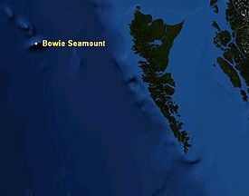
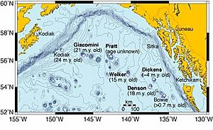
Map of Bowie Seamount
|
|

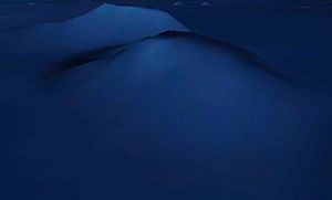
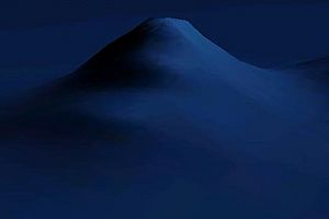
3-D depiction of Bowie Seamount
|
|
| Summit depth | 24 m (79 ft) |
| Height | ~3,000 m (9,843 ft) |
| Location | |
| Location | North Pacific Ocean, 180 km (112 mi) west of the Haida Gwaii |
| Coordinates | 53°18′24.93″N 135°39′33.23″W / 53.3069250°N 135.6592306°W |
| Country | Canada |
| Geology | |
| Type | Submarine volcano |
| Volcanic arc/chain | Kodiak-Bowie Seamount chain |
| Age of rock | Pleistocene |
| Last eruption | 18,000 years ago |
Bowie Seamount is a huge underwater volcano. It is found in the northeastern Pacific Ocean. This amazing natural wonder is about 180 km (110 mi) west of Haida Gwaii, British Columbia, Canada.
People also call this seamount Bowie Bank. In Russian language, it's known as Гора Бауи (Gora Baui), which means Mount Bowie. The Haida people call it SG̱aan Ḵinghlas. This means Supernatural One Looking Outward. The seamount is named after William Bowie. He was an engineer from the U.S. Coast and Geodetic Survey.
This volcano has a flat top. It rises about 3,000 m (10,000 ft) from the ocean floor. Its highest point is only 24 m (79 ft) below the sea surface. Bowie Seamount is at the southern end of a long underwater mountain range. This chain is called the Pratt-Welker or Kodiak-Bowie Seamount chain. It stretches from the Aleutian Trench in the north.
Bowie Seamount sits on the Pacific Plate. This is a giant piece of the Earth's surface. It slowly moves northwest under the Pacific Ocean. Two other underwater volcanoes are nearby. They are Hodgkins Seamount to the north and Graham Seamount to the east.
Contents
What is Bowie Seamount?
How it's Built
Seamounts are like mountains, but they rise from the ocean floor. The water around them makes them act differently from volcanoes on land. The lava that erupted from Bowie Seamount is called basalt. This is a common dark volcanic rock. When hot basalt lava touches cold seawater, it cools very fast. This creates special shapes called pillow lava. These look like stacked pillows.
Bowie Seamount is at least 3,000 m (10,000 ft) tall. It comes up to just 24 m (79 ft) below the sea surface. This makes it the shallowest underwater volcano in Canadian waters. It's also one of the shallowest in the northeast Pacific Ocean. Most seamounts are found thousands of metres deep. If Bowie Seamount were on land, it would be a very tall mountain!
Bowie Seamount is about 55 km (34 mi) long and 24 km (15 mi) wide. Its flat top has two levels or "terraces." The lower terrace is about 230 m (750 ft) deep. The higher one is about 80 m (260 ft) deep. But it has steeper peaks that reach up to 25 m (82 ft) below the surface. Bowie Seamount is very large and affects the ocean around it. It helps bring up nutrients from deeper waters. This makes the area rich in tiny ocean life called plankton.
When it Erupted
Bowie Seamount was formed by underwater eruptions. These happened during the last glacial period. This period, also called the "Wisconsinian," started about 110,000 years ago. It ended between 15,000 and 10,000 years ago. Most underwater volcanoes in the Pacific are over a million years old. But Bowie Seamount is quite young. Its base formed less than a million years ago. Its top shows signs of volcanic activity as recently as 18,000 years ago. This is very recent in Earth's history. It suggests the volcano might still be active.
Close to Bowie's top, there are signs of old coastlines and beach sand. This shows that Bowie Seamount was once above sea level. It might have been a single island or a small group of islands. During the last glacial period, sea levels were much lower. They were at least 100 m (300 ft) lower than today. Bowie Seamount would have been an island similar in size to Midway Atoll.
How it Formed
Scientists have different ideas about how Bowie Seamount formed. One idea is that the Kodiak-Bowie Seamount chain formed over a "hotspot." A hotspot is a place where hot rock from deep inside the Earth rises up. As the Pacific Plate moves, new seamounts form over this hotspot. They are then carried away from it.
The rocks from Bowie Seamount are special. They have some features like rocks from ocean islands. But they also have features like rocks from mid-ocean ridges. This means the magma that formed Bowie Seamount came from different sources deep in the Earth.
Some parts of the Kodiak-Bowie Seamount chain are still a mystery. For example, Bowie Seamount's top shows recent volcanic activity. But the seafloor it sits on formed 16 million years ago. If Bowie formed over a hotspot, it has moved a long way from its original magma source. Scientists are still studying these ideas.
Amazing Ocean Life
Bowie Seamount is home to a huge variety of ocean life. It's like a busy underwater city! Studies have found many crabs, sea stars, sea anemones, sponges, squid, octopus, rockfish, halibut, and sablefish. Eight types of marine mammals live here too. These include Steller sea lions, orcas, humpbacks, and sperm whales. Sixteen kinds of seabirds also visit the area.
This makes Bowie Seamount a very special place in the Pacific Ocean. It's one of the richest underwater volcanoes on Earth! All this life thrives because there's a lot of food. Tiny plants and animals, like phytoplankton and zooplankton, are abundant here.
Bowie Seamount Marine Protected Area
Because it's so full of life, Bowie Seamount was made a Marine Protected Area. This happened on April 19, 2008. It's Canada's seventh such area. People call it an "Oceanic Oasis." The announcement was made by government officials and Gidansda Guujaaw. He was the President of the Council of the Haida Nation.
The protected area is about 118 km (73 mi) long and 80 km (50 mi) wide. This covers a total area of 6,131 km2 (2,367 sq mi). This protection helps make sure this special place is safe for future generations. The Bowie Seamount Marine Protected Area also includes Peirce Seamount and Hodgkins Seamount.
Exploring Bowie Seamount
Bowie Seamount is shallow enough for scuba diving. This makes it the only underwater mountain off British Columbia that divers can easily reach. In March 1969, divers from the Canadian Forces Maritime Command explored the seamount. They took photos and collected samples of plants and animals. They found eleven types of sea bottom creatures.
In August 1969, more dives were made for scientific studies. Divers saw many rockfish swimming over Bowie's flat top. They also found a variety of life on the ocean floor.
In November 1996, National Geographic Magazine featured Bowie Seamount. Two explorers, Bill Curtsinger and Eric Hiner, dove down to 150 m (490 ft). Their photos showed Bowie's rugged peaks covered in seaweeds and colorful creatures. They also saw schools of young rockfish.
Scientists have studied videos from these dives. They identified many of the plants and animals living on the seamount. Some species that usually live in shallow water were found much deeper here. They were also larger than normal.
In August 2003, a team of five divers explored the seamount again. They took many photos and videos. They found 18 types of algae, 83 types of invertebrates, and 12 types of fish. They noted the thick schools of rockfish and curious prowfish.
Bowie Seamount and the Haida People
The Haida people, who are the first people of this area, played a big part in protecting Bowie Seamount. They call the underwater volcano SGaan Kinghlas. In their language, it means "Supernatural Being Looking Outward."
The Haida have always seen this seamount as a very special place. Gidansda Guujaaw, a former leader of the Council of the Haida Nation, said: "SGaan Kinghlas shows we need to respect and care for the Earth. This is a big step in helping ocean life recover."
A Warning for Ships
Because Bowie Bank is so shallow, it can be dangerous for ships. Waves as high as 27 m (89 ft) have been seen off the British Columbia Coast. These huge waves could expose the top of the seamount. This could cause serious damage to any ship passing over it. Because of this, Environment Canada warns ships to avoid Bowie Seamount.
 | Madam C. J. Walker |
 | Janet Emerson Bashen |
 | Annie Turnbo Malone |
 | Maggie L. Walker |


