Burke County, Georgia facts for kids
Quick facts for kids
Burke County
|
|
|---|---|

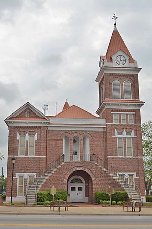
Burke County courthouse in Waynesboro, Georgia
|
|

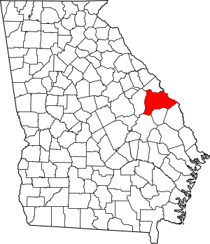
Location within the U.S. state of Georgia
|
|
 Georgia's location within the U.S. |
|
| Country | |
| State | |
| Founded | 1777 |
| Named for | Edmund Burke |
| Seat | Waynesboro |
| Largest city | Waynesboro |
| Area | |
| • Total | 835 sq mi (2,160 km2) |
| • Land | 827 sq mi (2,140 km2) |
| • Water | 8.0 sq mi (21 km2) 1.0%% |
| Population
(2020)
|
|
| • Total | 24,596 |
| • Density | 27/sq mi (10/km2) |
| Time zone | UTC−5 (Eastern) |
| • Summer (DST) | UTC−4 (EDT) |
| Congressional district | 12th |
Burke County is a special area called a county in the eastern part of Georgia. It's located in a region known as the Piedmont. In 2020, about 24,596 people lived here. The main town and government center, called the county seat, is Waynesboro. Burke County is also part of the larger Augusta-Richmond County area, which includes parts of South Carolina.
Contents
History of Burke County
Burke County was one of the very first counties created in Georgia. It was officially formed on February 5, 1777. The county is named after Edmund Burke, a famous English writer and politician. He was a Member of Parliament who belonged to the Whig Party. He believed that the American colonies should be treated fairly.
In 1779, during the American Revolutionary War, a battle took place here. Colonel John Twiggs and the brothers William and Benjamin Few led about 250 men. They fought against and defeated British forces in the Battle of Burke Jail.
Burke County is part of an area called the CSRA, which stands for the Central Savannah River Area. A long time ago, before the American Civil War, large cotton farms called plantations were common here. These farms used the labor of enslaved people. Because so many workers were needed for cotton, most people living in the county during that time were African American.
The county continued its military history during the American Civil War. Many people from Burke County joined different army units. Some of these units included the Burke Sharpshooters, Burke Guards, and Alexander Greys.
After the Civil War, farming remained the main way people made a living. Many freedmen, who were formerly enslaved people, worked as sharecroppers or tenant farmers. This meant they farmed land owned by others and paid rent with a share of their crops. Cotton was still the most important crop.
In the early 1900s, new machines made farming easier. This meant fewer people were needed to work on farms. Because of this, many African American farm workers lost their jobs.
From the 1900s to the 1970s, the number of people living in Burke County went down. This was partly due to the Great Migration. During this time, millions of African Americans moved from the rural South to cities in the Midwest and North. They were looking for better jobs and to escape unfair laws and treatment. Later, some also moved to West Coast cities for jobs in defense factories. White people also moved from rural areas to cities like Atlanta for work.
Geography of Burke County
Burke County covers a total area of about 835 square miles. Most of this is land (827 square miles), and a small part is water (8.0 square miles). It is the second-largest county in Georgia by land area.
The southern part of Burke County is in the Upper Ogeechee River sub-basin. This means its rivers and streams flow into the Ogeechee River. The area north of Waynesboro is part of the Brier Creek sub-basin. This area's water flows into the Savannah River. A very small northern section of the county is in the Middle Savannah River sub-basin.
Main Roads
Neighboring Counties
- Richmond County (north)
- Aiken County, South Carolina (northeast)
- Barnwell County, South Carolina (east-northeast)
- Allendale County, South Carolina (east)
- Screven County (southeast)
- Jenkins County (south)
- Emanuel County (southwest)
- Jefferson County (west)
Towns and Communities
Burke County has several towns and communities where people live.
Cities
- Midville
- Sardis
- Vidette
- Waynesboro (This is the county seat, where the main government offices are.)
Towns
Other Communities
These are smaller places that are not officially cities or towns.
- Drone
- Gough
Population Information
| Historical population | |||
|---|---|---|---|
| Census | Pop. | %± | |
| 1790 | 9,467 | — | |
| 1800 | 9,504 | 0.4% | |
| 1810 | 10,858 | 14.2% | |
| 1820 | 11,577 | 6.6% | |
| 1830 | 11,833 | 2.2% | |
| 1840 | 13,176 | 11.3% | |
| 1850 | 16,100 | 22.2% | |
| 1860 | 17,165 | 6.6% | |
| 1870 | 17,679 | 3.0% | |
| 1880 | 27,128 | 53.4% | |
| 1890 | 28,501 | 5.1% | |
| 1900 | 30,165 | 5.8% | |
| 1910 | 27,268 | −9.6% | |
| 1920 | 30,836 | 13.1% | |
| 1930 | 29,224 | −5.2% | |
| 1940 | 26,520 | −9.3% | |
| 1950 | 23,458 | −11.5% | |
| 1960 | 20,596 | −12.2% | |
| 1970 | 18,255 | −11.4% | |
| 1980 | 19,349 | 6.0% | |
| 1990 | 20,579 | 6.4% | |
| 2000 | 22,243 | 8.1% | |
| 2010 | 23,316 | 4.8% | |
| 2020 | 24,596 | 5.5% | |
| 2023 (est.) | 24,438 | 4.8% | |
| U.S. Decennial Census 1790-18801890-1910 1920-1930 1930-1940 1940-1950 1960-1980 1980-2000 |
|||
In 2020, the census counted 24,596 people living in Burke County. There were 8,193 households, which means groups of people living together.
The population of Burke County has changed over time. For example, from 1900 to 1910, the population decreased. It also went down from the 1920s to the 1970s. However, since 1980, the population has generally been growing.
Education in Burke County
Students in Burke County attend schools that are part of the Burke County School District. The district has several schools for different age groups.
Public Schools
- SGA Elementary School (for students from Pre-Kindergarten to 5th grade)
- Blakeney Elementary School (for students in 3rd to 5th grade)
- Waynesboro Primary School (for students from Pre-Kindergarten to 2nd grade)
- Burke County Middle School (for students in 6th to 8th grade)
- Burke County High School (for students in 9th to 12th grade)
- Burke County Alternative School (for students in 6th to 12th grade)
Private Schools
There are also private schools in the county:
- Faith Christian Academy (for students from Pre-Kindergarten to 12th grade)
- Edmund Burke Academy (for students from Pre-Kindergarten to 12th grade)
- Waynesboro Mennonite School (for students in 1st to 12th grade)
See also
 In Spanish: Condado de Burke (Georgia) para niños
 | William Lucy |
 | Charles Hayes |
 | Cleveland Robinson |

