Cañón de Santa Elena Flora and Fauna Protection Area facts for kids
Quick facts for kids Cañón de Santa Elena |
|
|---|---|
| Área de Protección de Flora y Fauna Cañón de Santa Elena | |
|
IUCN Category VI (Managed Resource Protected Area)
|
|

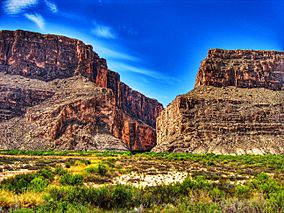
View of the Santa Elena Canyon from Big Bend National Park, U.S.
|
|
| Lua error in Module:Location_map at line 420: attempt to index field 'wikibase' (a nil value). | |
| Location | Municipalities of Manuel Benavides and Ojinaga, Chihuahua, Mexico |
| Area | 277,209 ha (685,000 acres) |
| Designation | Flora and fauna protection area |
| Designated | November 7, 1994 |
| Governing body | Mexico |
The Cañón de Santa Elena Flora and Fauna Protection Area is a special place in Mexico. It protects plants and animals in the state of Chihuahua. This area was created on November 7, 1994. It covers a huge space of 277,209 hectares.
The main goal of this reserve is to protect the Chihuahuan Desert. This desert is home to many unique plants and animals. You can find different types of desert plants here. There are also many birds and mammals that have learned to live in this dry place. Some examples are wildcats and different kinds of deer. You can also spot amazing birds of prey flying high above.
Contents
Exploring the Past: History of Santa Elena Canyon
People have lived in the Santa Elena Canyon area for a very long time. We know this because of things like arrowheads and tools found there. These items show that humans were present during different periods:
- The Paleo-Indian period (15,000–6,500 years BC)
- The Archaic period (6500 BC – 900 AD)
- The early Postclassic period (900–1500 AD)
- The late Postclassic period (1300–1680 AD)
These early people moved around with the seasons to find food. They would fish, gather plants, hunt, and even do some farming. Different groups of people passed through this area. These included the Conchos, Jumano, Chisos, and various Apaches like the Chiricahua, Mescaleros, and Lipanes.
Later, the Spanish and Comanche people arrived. The colonial government set up the Rio Grande as a defense line. They built small fortifications, or forts, with soldiers to guard them. These forts included San Carlos in Chihuahua. The region stayed mostly empty until about 1890 because of attacks from Apache and Comanche tribes.
Around 1784, the San Carlos fort was left empty. Only travelers used it for protection. The first local government for the municipality of Ojinaga was created in 1824. A part of San Carlos, now called Manuel Benavides, was added to it in 1831.
The Land: Geography of Santa Elena Canyon

The Cañón de Santa Elena protected area is part of the Chihuahuan desert. This region has many mountain ranges with valleys and flat plains in between. The types of plants here are very diverse. This is because the land goes from about 700 meters (2,300 feet) to 2,400 meters (7,900 feet) above sea level.
Where is Santa Elena Canyon?
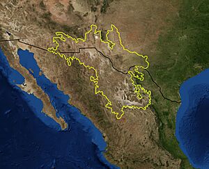
The Santa Elena Canyon is in the state of Chihuahua. To the north, it borders the Rio Grande, which is the river that separates Mexico from the United States. To the east, it borders the state of Coahuila. Most of the reserve (80%) is in the towns of Manuel Benavides and Ojinaga. It stretches about 30 kilometers (19 miles) wide and 100 kilometers (62 miles) long. The highest point is about 2,400 meters (7,900 feet) above sea level. It is next to the Ocampo Flora and Fauna Protection Area on its eastern side.
How the Land Was Formed: Geology
The area is mostly made of Cretaceous limestone rock. Later, in the mid-Tertiary period, volcanic activity happened. This volcanism caused the land to fold and break into large blocks. Some blocks lifted up, forming mountains, and others sank, creating depressions or valleys. You can also find older metamorphic rocks and igneous intrusions in some parts.
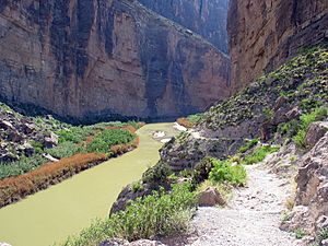
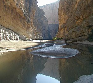
The Santa Elena Canyon area includes mountain ranges like El Ranchito and Sierra Rica. Between these mountains are valleys such as Alamo and El Mulato. There are also lower hills like Manuel Benavides. The area has two deep canyons: La Gaviota, which is 656 meters (2,152 feet) deep, and Santa Elena, which is 467 meters (1,532 feet) deep. Much of the area is flat, with gentle slopes.
Weather: Climate
The climate in this area is very dry and hot. Temperatures can reach up to 50°C (122°F) in the summer! There's a big difference between the hot desert and the cooler, higher areas. It's an arid region, meaning it gets very little rain, mostly in the summer.
Who Lives Here: Demographics
The main villages in the protected area are Manuel Benavides, Loma de Juárez, and Santa Elena. Other nearby towns include Ojinaga. About 2,578 people live inside the protected area.
The land in the reserve is used for different things. Some parts are private properties, some are ejidos (community-owned lands), and some are public lands. People in the area use the land for farming, raising livestock, and mining.
Plants and Animals: Flora and Fauna

The Cañón de Santa Elena is home to many different species. About 79 of these species are protected. This includes 13 types of plants, mostly cacti. The other 66 are animal species. Some important animals found here are the black bear, the golden eagle, the peregrine falcon, and the beaver.
The area has a wide variety of plants. You'll find different kinds of desert shrubs like Guamis and mariola. There are also grasslands, oak forests, and plants that grow near rivers, like poplars and willows. In the desert, you can see lechuguilla, sotol, and many types of cactus.
The animals in the region have adapted to the dry conditions. You might see black-tailed jackrabbits, bobcats, whitetail deer, mule deer, and collared peccarys. There are also birds like mourning doves and ducks. Coyotes are also present. Important birds of prey include the peregrine falcon, the kestrel, and the golden eagle. Many songbirds and fish species also live here.
How the Protected Area Was Created
In 1990, the state of Chihuahua asked for a new protected area. They wanted it to be near the Big Bend National Park in the United States. After talking with local people, the region was officially named a Protected Area of Flora and Fauna in 1994. This area was also included in an older Forest Protected Area from 1934. That older area was meant to protect water sources for the Amistad Reservoir in Coahuila.
The United States government had wanted a protected area in Mexico since 1934. They hoped it would be a partner to their Big Bend National Park. These ideas didn't happen until 1994, except for the Forest Protection Department created in 1934.

Dangers to the Reserve
The Cañón de Santa Elena protected area faces several threats, all caused by people.
- Overuse of land: Sometimes, too many animals are raised on the pasture land. This can damage the plants.
- Clearing land: Some people clear land for new farms. This causes native plant species to be lost.
- Mining: Mining operations take materials from the ground, which can harm the environment.
- Smuggling: There's a problem with people illegally taking plants, especially cacti. They also take fossils and old artifacts from the area.
- Uncontrolled tourism: Too many visitors without proper rules can accidentally damage parts of the reserve.
Why This Reserve Is Important: Goals
This reserve was created for several key reasons:
- To protect a part of the Chihuahuan desert ecosystem.
- To work with protected areas across the border in Texas, USA. This helps protect the whole ecosystem and allows for joint environmental efforts.
- A study in 1994 showed that the region needs protection. It has many endangered species (13 plant species and 66 animal species).
- The area also has important geological features, water sources, and historical sites. It has a striking contrast between desert and forest ecosystems.
See also
 In Spanish: Área de protección de flora y fauna Cañón de Santa Elena para niños
- Mexico–United States international park
 | Charles R. Drew |
 | Benjamin Banneker |
 | Jane C. Wright |
 | Roger Arliner Young |


