
Calabazas Creek (Sonoma County) facts for kids
Quick facts for kids Calabazas Creek |
|
|---|---|

|
|

Location of the mouth of Calabazas Creek in California
|
|
| Country | United States |
| State | California |
| Region | Sonoma County |
| City | Glen Ellen, California |
| Physical characteristics | |
| Main source | Mayacamas Mountains 4 mi (6 km) northeast of Glen Ellen, California 530 ft (160 m) 38°23′54″N 122°28′26″W / 38.39833°N 122.47389°W |
| River mouth | Sonoma Creek Glen Ellen, California 236 ft (72 m) 38°21′45″N 122°31′29″W / 38.36250°N 122.52472°W |
| Length | 5.2 mi (8.4 km) |
| Basin features | |
| Basin size | 7.7 sq mi (20 km2) |
| Tributaries |
|
Calabazas Creek is a stream about 5.5 miles (8.9 km) long. It flows through the Sonoma Valley in California, United States. The creek starts high up in the southern Mayacamas Mountains. It then travels through the valley and eventually flows into Sonoma Creek near the town of Glen Ellen.
Contents
History of Calabazas Creek
The name Calabazas comes from the Spanish language. It means "squash," "pumpkins," or "gourds." This name was used on an old map from 1840 for a piece of land called Agua Caliente.
One of the oldest stone arch bridges in Sonoma County crosses Calabazas Creek. This bridge was built in 1915.
In 2004, a group called the Sonoma County Agricultural Preservation and Open Space District bought 1,290 acres (5.2 square kilometers) of land around the creek. They did this to protect the area. They made a plan in 2016 to manage the land. They will also create a plan for people to visit the area in the future.
Wildlife and Nature in the Creek
Calabazas Creek used to have many steelhead fish. Steelhead are a type of Rainbow trout that live in the ocean and swim upstream to lay eggs. Studies in 2001 showed that there was enough gravel for the fish to lay their eggs. There also wasn't too much sediment (dirt and sand) blocking their way.
Steelhead fish were still found in the creek when the Open Space District studied the area in 2016. This means the creek is still a good home for them.
Upper and Lower Creek Areas
The upper parts of Calabazas Creek are very natural and untouched. They have thick forests with many different kinds of oak trees. This is called an oak woodland.
However, the lower parts of the creek, closer to the Sonoma Valley floor, have more human activity. There are homes, vineyards (where grapes are grown), and other farms nearby.
How the Creek's Land Formed
About 12 million years ago, the area where Calabazas Creek is now was actually under the Pacific Ocean. Over time, the Earth's plates moved. This movement, along with hot magma (melted rock) deep underground, caused the land to push up. This process is called uplift.
This uplift created the Mayacamas Mountains, which are made mostly of volcanic rock. You can still see signs of this ancient activity today. There are scattered rocks like basalt and rhyolite. You can also find hot springs nearby, like Mortons Hot Springs and Agua Caliente Hot Springs.
In the past, people used to dig for rocks in a quarry near Nunns Canyon Road, in the upper part of the Calabazas Creek area.
The Creek's Path
Calabazas Creek starts about 4 miles (6.4 km) northeast of Glen Ellen, California. It begins near Trinity Road, at the top of a place called Nunns Canyon. Several small, unnamed streams come together to form the creek here.
The creek flows west through Nunns Canyon, following Nunns Canyon Road. It gets more water from Nunns Iron Spring and other smaller streams.
From Canyon to Valley
After leaving the canyon, the creek enters the Valley of the Moon. It then turns south. It flows under State Route 12 and passes west of the town of Agua Caliente.
As it flows south along Henno Road into Glen Ellen, another stream called Stuart Creek joins it. Finally, after crossing Arnold Drive, Calabazas Creek flows into Sonoma Creek.
The Upper Calabazas Creek Area
The "upper reach" of Calabazas Creek is the part north of State Route 12. This section is about three miles upstream from where it meets Sonoma Creek.
At first, there are two large ranches, Beltane Ranch and Atwood Ranch, on either side of the creek. As you go further upstream, Nunns Canyon Road runs close to the creek, so you can see it easily. There's also an old rock quarry about 0.3 miles (500 meters) north of State Route 12.
Calabazas Creek Open Space Preserve
Where Nunns Canyon Road ends, Calabazas Creek flows into a large nature preserve. This preserve is 1,290 acres (5.2 square kilometers) and is owned by the Sonoma County Open Space District. As of 2007, people cannot visit this area yet. It is called the Calabazas Creek Open Space Preserve.
This preserve has a very healthy riparian zone (the area along the creek). It also has a high-quality California oak woodland. Much of this area is undisturbed, meaning it's a natural ecosystem with many different kinds of plants and animals. This is especially true in the upper 1.7 miles (2.5 km) of the creek's beginning. Some of the steep, forested areas are great examples of these woodlands. This shows that they haven't been heavily used for grazing animals or farming in the past.
Plants and Animals in the Preserve
Besides the plants along the creek, the main type of plant community is the oak woodland. The tallest trees, forming the canopy, include:
Underneath these tall trees, you can find plants like:
Many animals live here too, such as:
Sometimes, mountain lions are also seen. There are many different kinds of birds, including:
- Scrub jay
- Steller's jay
- Acorn woodpecker
- Black phoebe
- Junco
Near the creek, you can also find amphibians like the rough-skinned newt (Taricha granulosa).
Images for kids
-
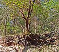
A Madrone tree in the upper part of Calabazas Creek. Its shallow roots show the thin soil.
-
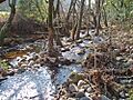
The Riparian zone habitat in the upper part of Calabazas Creek.


