
Cheviot Hills, Los Angeles facts for kids
Quick facts for kids
Cheviot Hills
|
|
|---|---|

Cheviot Hills
Location in Western Los Angeles
|
|
| Country | United States |
| State | California |
| County | Los Angeles |
| City | Los Angeles |
| Time zone | Pacific |
| Zip Code |
90064
|
| Area code(s) | 310 |
| Website | cheviothills.org |
Cheviot Hills is a neighborhood located on the Westside of Los Angeles, California. It was established in 1924.
This area is famous for being a filming spot for movies and TV shows. It's conveniently located between major film studios like Sony Studios and Fox Studios. Many actors, musicians, and studio leaders have called Cheviot Hills home over the years.
Contents
Where is Cheviot Hills Located?

Cheviot Hills is surrounded by several important landmarks and other neighborhoods. To the north, you'll find the Rancho Park Golf Course and the Hillcrest Country Club. On its western and southwestern sides are Patricia Avenue and Manning Avenue. To the east and southeast, it's bordered by Beverwil Drive and Castle Heights Avenue.
The neighborhood is next to West Los Angeles and Century City to the north. To the east, it borders Beverlywood and Castle Heights. To the south, you'll find Palms, and to the west, it's next to Rancho Park.
Who Lives in Cheviot Hills?

In 2000, about 6,945 people lived in Cheviot Hills. The neighborhood covers about 1.54 square miles. This area includes large open spaces like Cheviot Hills Park, the Rancho Park Golf Course, and the Hillcrest Country Club.
Cheviot Hills Park is a great place for fun activities. It has a recreation center, basketball courts, and a baseball league. There's even an archery range! By 2008, the population had grown to an estimated 7,303 people. The average age of residents was 42, which is a bit older than the average for Los Angeles.
The neighborhood is mostly made up of white residents compared to other parts of Los Angeles. About 78.8% of the people are white, 9.1% are Asian, and 8.3% are Hispanic or Latino. A smaller number of residents were born outside the U.S., with Japan and Mexico being the most common birthplaces.
Families in Cheviot Hills generally have a high income. In 2008, the average yearly household income was about $111,813. Most people living here own their homes (64.3%), while 35.7% rent.
A Look at Cheviot Hills History

Most of Cheviot Hills was once part of a large Spanish land grant called Rancho Rincon de los Bueyes. For a long time, the area was mostly undeveloped. Homes started to be built in the western part of the neighborhood in the 1920s.
From the 1920s until 1953, a streetcar line called the Santa Monica Air Line ran along the southern edge of Cheviot Hills. This streetcar helped people travel between Cheviot Hills, downtown Los Angeles, and downtown Santa Monica. Many homes in the eastern part of the neighborhood were built in the early 1950s. This area used to be the site of the California Country Club.
Cheviot Hills features homes designed by famous architects. These include the Strauss-Lewis House by Raphael Soriano and the Harry Culver Estate, designed by Wallace Neff.
Originally, Cheviot Hills was a middle-class neighborhood. In 1926, homes started at $50,000. However, home prices have gone up a lot in recent years. Now, they are similar to those in nearby wealthy areas like Beverly Hills and Bel Air. This has led to many new homes being built, sometimes replacing the original 1920s houses.
Because of its rising home values, Cheviot Hills was named one of the "hottest" neighborhoods for real estate in the country in 2014 and in Los Angeles in 2015.
Monte Mar Vista: A Special Area
Monte Mar Vista was developed between 1926 and 1940. It is known as the most affluent part of Cheviot Hills. This area has sixteen blocks located on the northern side of the neighborhood. It is bordered by the Hillcrest Country Club, Cheviot Hills Park, and Rancho Park Golf Course.
Many homes in Monte Mar Vista have amazing views. They can see the Hillcrest Country Club, Rancho Park Golf Course, Century City, the Hollywood Hills, and even the Hollywood Sign. The lots here are often very large. Homes were designed by well-known architects like John L. DeLario, Roland E. Coartes, Wallace Neff, and Eugene R. Ward. The very first house designed by Craig Ellwood, called Lappin House, is also in this part of Cheviot Hills.
California Country Club Estates
California Country Club Estates was built in 1952. It sits on the land where the California Country Club used to be. This neighborhood has single-family homes and is sometimes called "New Cheviot," while the rest of Cheviot Hills is called "Old Cheviot."
It is located within Cheviot Hills, bordered by Club Drive to the north and Queensbury Drive to the west. This area has its own homeowners' association and special rules for each property. Its borders are marked by signs and central medians. The neighborhood was first developed by Sanford Adler, who owned famous hotels like the Flamingo Las Vegas. It includes homes built by architects such as A. Quincy Jones.
Filming in Cheviot Hills
Because Cheviot Hills is so close to Fox Studios and Sony Pictures Studios, it has often been used as a location for movies and TV shows.
Some early examples from the 1920s and 1930s include the Laurel and Hardy films The Finishing Touch, Big Business, and Bacon Grabbers. Later, the TV series The Ropers (from the late 1970s) and the movie Private School (in 1983) were also filmed here.
Famous People from Cheviot Hills
Many well-known individuals have lived in Cheviot Hills. Here are some of them:
- L. B. Abbott, cinematographer
- Maria Altmann, recovered famous paintings
- Lucie Arnaz, actress
- Lucille Ball, actress
- Travis Barker, drummer from Blink-182
- Nuno Bettencourt, musician
- Barbara Bel Geddes, actress
- Bruce Bennett, Olympic medalist and actor
- Arthur Bergh, composer
- Jan Berry, singer
- Benjamin Franklin Bledsoe, judge
- Ray Bradbury, author
- Ty Burrell, actor
- J. Curtis Counts, government official
- Harry Culver, real estate developer
- Vic Damone, singer
- Glenn Danzig, singer
- Brooklyn Decker, model and actress
- Kelly Emberg, model
- Alex Haley, author
- June Haver, actress
- Ted Healy, actor and creator of The Three Stooges
- Jonah Hill, actor
- Marin Hinkle, actress
- Anna Homler, artist
- Marianne Jean-Baptiste, actress
- Buster Keaton, actor
- Stan Laurel, actor
- Helie Lee, author and director
- Laurie Levenson, law professor
- Dave Madden, actor
- Marjorie Main, actress
- Thom Mayne, architect
- Michael McKean, actor
- Ken Mok, television producer
- Christopher Miller, writer, director, producer
- Agnes Moorehead, actress
- Trevor Morris, music producer and composer
- Bill Mumy, actor
- Joel Murray, actor
- George Newbern, actor
- Annette O'Toole, actress
- Jack Paar, comedian
- John Payne, actor
- Michelle Phillips, singer from The Mamas & the Papas
- Paul Pierce, NBA player
- Mary Kay Place, actress
- Maureen Reagan, actress and daughter of Ronald Reagan
- Andy Roddick, professional tennis player
- Leo Rosten, screenwriter
- Hal Roach, film and television producer
- William Shatner, actor (Captain James T. Kirk in Star Trek)
- Phil Silvers, actor
- Patrick Soon-Shiong, billionaire and founder of companies
- Pam Teeguarden, professional tennis player
- Henri Temianka, musician
- Daniel Thompson, inventor
- Marshall Thompson, actor
- Rudy Tomjanovich, former NBA player
- Joseph A. Valentine, cinematographer
- Tasia Valenza, actress
- Johnny Weissmuller, Olympic medalist and actor (Tarzan)
- Pete Wilson, former governor of California
- Valerie Zimring, Olympic medalist
Images for kids
-
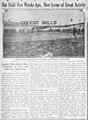
An advertisement for "Cheviot Hills" from 1923.
-
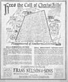
Another advertisement from 1923, inviting people to Cheviot Hills.


