
Fredericton facts for kids
Quick facts for kids
Fredericton
|
|||||
|---|---|---|---|---|---|
|
City
|
|||||
| The City of Fredericton | |||||
 .jpg)   From top to bottom; left to right: Fredericton skyline, Pedestrian bridge of the Nashwaak River, Christ Church Cathedral, New Brunswick Legislative Building
|
|||||
|
|||||
| Nicknames:
Freddy, Freddy Beach
|
|||||
| Motto(s): | |||||

Fredericton
Location in New Brunswick

Fredericton
Location in Canada
|
|||||
| Country | Canada | ||||
| Province | New Brunswick | ||||
| County(s) | York, Sunbury | ||||
| Metropolitan area | Greater Fredericton | ||||
| Erected | 1786 | ||||
| Incorporated | 1848 | ||||
| Named for | Prince Frederick, Duke of York and Albany | ||||
| Government | |||||
| • Type | Fredericton City Council | ||||
| Area | |||||
| • City | 133.93 km2 (51.71 sq mi) | ||||
| • Metro | 5,745.41 km2 (2,218.32 sq mi) | ||||
| Elevation | 20-100 m (66-328 ft) | ||||
| Population
(2021)
|
|||||
| • City | 63,116 | ||||
| • Density | 471.3/km2 (1,221/sq mi) | ||||
| • Metro | 108,610 | ||||
| • Metro density | 17.7/km2 (46/sq mi) | ||||
| Demonym(s) | Frederictonian | ||||
| Time zone | UTC−04:00 (AST) | ||||
| • Summer (DST) | UTC−03:00 (ADT) | ||||
| Postal code(s) |
E3A, E3B, E3C, E3E, E3G
|
||||
| Area code | 506 and 428 | ||||
| NTS Map | 21G15 Fredericton | ||||
| GNBC Code | DAFMJ | ||||


Fredericton is the capital city of the Canadian province of New Brunswick. It sits in the middle-west part of the province along the Saint John River. This river, also known by its Indigenous name of Wolastoq, flows through the city from west to east. It's a very important natural feature of the area.
Fredericton is one of New Brunswick's main cities. In 2021, about 63,116 people lived in the city. If you include the surrounding areas, the population was about 108,610. It is the third-largest city in the province, after Moncton and Saint John.
On January 1, 2023, Fredericton grew by adding parts of five nearby areas. New population numbers will be released later.
Fredericton is a key place for culture, art, and education in New Brunswick. It has two universities: The University of New Brunswick and St. Thomas University. You can also find the New Brunswick College of Craft and Design and New Brunswick Community College here.
The city is home to cool places like the Beaverbrook Art Gallery, the Fredericton Region Museum, and The Playhouse, which is a place for live shows. Fredericton hosts the yearly Harvest Jazz & Blues Festival. This festival brings in jazz, blues, rock, and world music artists from all over. During the summer, the Garrison Night Market is also held, where local sellers, artists, and musicians show their work. Many famous New Brunswick artists live and work in Fredericton. Some historical Canadian painters like Goodridge Roberts, and Molly and Bruno Bobak also lived here.
Because Fredericton is the provincial capital, many jobs are with the government. But the city also has a growing technology and business sector. Fredericton has the most people with college or university degrees in the province. It also has the highest income per person of any city in New Brunswick.
Contents
Fredericton's Rich History
The area where Fredericton is today has been lived in for a very long time. Archaeologists have found proof that people were here 12,000 years ago. They found an old campsite with a fire pit and over 600 tools and arrowheads made of stone.
The Maliseet people first used this area for farming during different seasons. They grew foods like beans, pumpkins, and corn along the Saint John River and its islands. In the mid-1700s, their main village, Aucpaque, was a few kilometers upriver from where Fredericton is now.
French Settlement and Forts
The first Europeans to arrive were the French in the late 1600s. Joseph Robineau de Villebon was given land and became the governor of Acadia. During King William's War, Villebon built Fort Nashwaak on the north side of the Saint John River, near the mouth of the Nashwaak River. For most of this war, Fort Nashwaak was the capital of the French colony of Acadia. From here, French and Indigenous forces launched attacks on English settlers.
Battles and Changes
Fighting continued between the French and English. In 1696, English forces tried to destroy Fort Nashwaak. But Commander Villebon was ready. After two days of fierce fighting, the English were defeated.
After Villebon died in 1700 and a big flood hit, the fort was left empty. The Fredericton area was first settled permanently in 1732. Acadians who were leaving Nova Scotia after the British took over the area (in 1710) named it Pointe-Sainte-Anne. Their town was on the south side of the river.
During the French and Indian War in 1759, the British captured Pointe-Sainte-Anne. They burned the settlement to the ground.
An attempt by the British to settle here in 1762 didn't work because the local Acadian and Indigenous people were not friendly. These settlers later moved downriver to what is now Maugerville. However, three fur traders settled permanently in the Fredericton area in 1768.

British Rule and New Beginnings
In 1783, people called United Empire Loyalists moved to Ste. Anne's Point. They were people who supported the British during the American Revolution and left their homes in the United States. The British Crown gave them land in Canada. Many Loyalists died during the very cold first winter in Fredericton. They were buried in the Loyalist cemetery, which you can still find on the south bank of the Saint John River.
When New Brunswick became its own colony separate from Nova Scotia in 1784, Ste. Anne's Point became the capital. It was chosen over Saint John because it was inland and safer from attacks by sea. A new street plan was made, and King's College (now the University of New Brunswick) was started. The area was renamed "Frederick's Town" to honor Prince Frederick Augustus, the second son of King George III. The name was shortened to Fredericton soon after, on April 25, 1785, when it became the official capital. So, in less than three years, Fredericton went from a quiet area to the capital of a new colony.
Being the capital also made Fredericton a good place for a military base. Many of the old military buildings downtown are still there today and are popular tourist spots.
Fredericton in the Canadian Era
The building where the government met in 1788 burned down in 1880. Two years later, the current Legislature Building was built.
Fredericton grew a lot on July 1, 1945, when it joined with the town of Devon. Today, Fredericton includes the main city and areas like Silverwood, Nashwaaksis, Barker's Point, and Marysville. These areas became part of the city in 1973.
Marysville's Unique Past
Marysville, one of the communities that joined Fredericton in 1973, has its own special history. It is located on the Nashwaak River, a branch of the Saint John River, just north of old Fredericton. Marysville is known for its 19th-century mill and historic buildings. These include old company houses and buildings that look like those from British factory towns.
Marysville is a great example of a 19th-century mill town. In the 1830s, a sawmill was built there. But it often changed owners and didn't make money. Then, Alexander Gibson, known as "Boss Gibson," changed everything. He built a successful industrial town. In 1883, Gibson started building a cotton mill that was very modern for its time. "Boss" Gibson named the town Marysville to honor his wife.
In 1908, Gibson sold the mill. After World War II, the mill faced problems from foreign competition and closed in 1954. It tried to reopen several times but closed for good in 1980.
The mill was fixed up and reopened in 1985. It is now used for provincial government offices. The mill is still the most noticeable building in Marysville.
A key part of Marysville is the Alexander Gibson Memorial School, or AGMS. It was built in 1926. Additions were made in 1957 and 1977 after a fire. It used to teach over 300 children from kindergarten to grade 5. The school is no longer running, and the building is now used by the Ville Cooperative.
Fredericton's Geography and Climate
The Saint John River flows right through Fredericton. The city's main downtown area is on the flat land next to the river. Most of the newer neighborhoods are on the gentle hills of the river valley.
Fredericton is about 17 meters (56 feet) above sea level. It sits in a basin, which is a low area of land. The city has two different land areas. In the west, the land is shaped by the rocks underneath. In the east, it's shaped by newer soil and river deposits, making the area wide and shallow. Fredericton has lots of water and good soil, which is great for farming. The Saint John River and the Nashwaak River meet here. The parts of the city that aren't built up are covered in thick forests.
Fredericton's Weather
Fredericton has a climate with warm summers and long, cold winters. The city gets a lot of humidity and rain or snow all year. On average, Fredericton receives about 1,100 millimeters (43 inches) of precipitation each year.
| Weather chart for Fredericton | |||||||||||||||||||||||||||||||||||||||||||||||
|---|---|---|---|---|---|---|---|---|---|---|---|---|---|---|---|---|---|---|---|---|---|---|---|---|---|---|---|---|---|---|---|---|---|---|---|---|---|---|---|---|---|---|---|---|---|---|---|
| J | F | M | A | M | J | J | A | S | O | N | D | ||||||||||||||||||||||||||||||||||||
|
95
-4
-15
|
73
-2
-14
|
93
3
-8
|
86
10
-1
|
96
18
5
|
82
23
10
|
88
26
13
|
86
25
12
|
88
20
7
|
89
13
2
|
106
6
-3
|
95
-1
-11
|
||||||||||||||||||||||||||||||||||||
| temperatures in °C precipitation totals in mm source: Environment and Climate Change Canada |
|||||||||||||||||||||||||||||||||||||||||||||||
|
Imperial conversion
|
|||||||||||||||||||||||||||||||||||||||||||||||
| Climate data for Fredericton CDA Climate ID: 8101600; coordinates 45°55′N 66°37′W / 45.917°N 66.617°W; elevation: 39.6 m (130 ft); 1981–2010 normals, extremes 1871–present |
|||||||||||||
|---|---|---|---|---|---|---|---|---|---|---|---|---|---|
| Month | Jan | Feb | Mar | Apr | May | Jun | Jul | Aug | Sep | Oct | Nov | Dec | Year |
| Record high °C (°F) | 15.0 (59.0) |
19.0 (66.2) |
26.5 (79.7) |
30.5 (86.9) |
35.5 (95.9) |
35.6 (96.1) |
36.1 (97.0) |
38.9 (102.0) |
33.7 (92.7) |
28.9 (84.0) |
21.7 (71.1) |
16.1 (61.0) |
38.9 (102.0) |
| Mean daily maximum °C (°F) | −4.4 (24.1) |
−2.1 (28.2) |
2.8 (37.0) |
9.9 (49.8) |
17.6 (63.7) |
22.7 (72.9) |
25.4 (77.7) |
24.5 (76.1) |
19.6 (67.3) |
12.8 (55.0) |
5.5 (41.9) |
−1.0 (30.2) |
11.1 (52.0) |
| Daily mean °C (°F) | −9.4 (15.1) |
−7.5 (18.5) |
−2.2 (28.0) |
4.8 (40.6) |
11.3 (52.3) |
16.4 (61.5) |
19.4 (66.9) |
18.6 (65.5) |
14.0 (57.2) |
7.8 (46.0) |
1.8 (35.2) |
−5.3 (22.5) |
5.8 (42.4) |
| Mean daily minimum °C (°F) | −14.4 (6.1) |
−12.8 (9.0) |
−7.2 (19.0) |
−0.4 (31.3) |
5.1 (41.2) |
10.1 (50.2) |
13.3 (55.9) |
12.6 (54.7) |
8.3 (46.9) |
2.8 (37.0) |
−2.0 (28.4) |
−9.5 (14.9) |
0.5 (32.9) |
| Record low °C (°F) | −38.9 (−38.0) |
−38.3 (−36.9) |
−32.8 (−27.0) |
−20.0 (−4.0) |
−6.7 (19.9) |
−2.2 (28.0) |
1.7 (35.1) |
1.7 (35.1) |
−4.4 (24.1) |
−11.1 (12.0) |
−26.7 (−16.1) |
−35.6 (−32.1) |
−38.9 (−38.0) |
| Average precipitation mm (inches) | 101.9 (4.01) |
70.1 (2.76) |
90.1 (3.55) |
81.6 (3.21) |
103.8 (4.09) |
86.3 (3.40) |
89.0 (3.50) |
85.9 (3.38) |
94.7 (3.73) |
89.7 (3.53) |
109.9 (4.33) |
91.8 (3.61) |
1,094.7 (43.10) |
| Average rainfall mm (inches) | 42.4 (1.67) |
31.7 (1.25) |
45.2 (1.78) |
68.1 (2.68) |
103.1 (4.06) |
86.3 (3.40) |
89.0 (3.50) |
85.9 (3.38) |
94.7 (3.73) |
89.3 (3.52) |
96.3 (3.79) |
54.0 (2.13) |
885.9 (34.88) |
| Average snowfall cm (inches) | 63.6 (25.0) |
39.1 (15.4) |
42.4 (16.7) |
13.5 (5.3) |
0.6 (0.2) |
0.0 (0.0) |
0.0 (0.0) |
0.0 (0.0) |
0.0 (0.0) |
0.4 (0.2) |
13.9 (5.5) |
41.4 (16.3) |
214.8 (84.6) |
| Average precipitation days (≥ 0.2 mm) | 12.6 | 10.2 | 12.4 | 12.6 | 14.9 | 13.6 | 14.5 | 12.7 | 13.7 | 13.5 | 13.8 | 12.5 | 156.7 |
| Average rainy days (≥ 0.2 mm) | 4.5 | 4.2 | 7.1 | 10.8 | 14.8 | 13.6 | 14.5 | 12.7 | 13.7 | 13.5 | 11.7 | 6.0 | 126.9 |
| Average snowy days (≥ 0.2 cm) | 9.4 | 7.2 | 7.0 | 2.4 | 0.3 | 0.0 | 0.0 | 0.0 | 0.0 | 0.11 | 3.2 | 7.5 | 37.0 |
| Mean monthly sunshine hours | 119.5 | 130.8 | 148.9 | 162.2 | 206.9 | 224.3 | 239.7 | 226.2 | 172.4 | 142.5 | 95.8 | 102.2 | 1,971.2 |
| Percent possible sunshine | 42.4 | 44.8 | 40.4 | 40.0 | 44.7 | 47.7 | 50.4 | 51.6 | 45.7 | 41.9 | 33.6 | 37.8 | 43.4 |
| Source: Environment and Climate Change Canada | |||||||||||||
| Climate data for Fredericton (Fredericton Airport) Climate ID: 8101600; coordinates 45°52′19.67″N 66°31′40.411″W / 45.8721306°N 66.52789194°W; elevation: 20.7 m (68 ft); 1981–2010 normals, extremes 1951–present |
|||||||||||||
|---|---|---|---|---|---|---|---|---|---|---|---|---|---|
| Month | Jan | Feb | Mar | Apr | May | Jun | Jul | Aug | Sep | Oct | Nov | Dec | Year |
| Record high humidex | 17.1 | 17.3 | 28.0 | 33.3 | 38.1 | 43.5 | 44.5 | 43.3 | 39.6 | 32.0 | 25.0 | 19.5 | 44.5 |
| Record high °C (°F) | 14.6 (58.3) |
18.6 (65.5) |
27.2 (81.0) |
30.3 (86.5) |
35.2 (95.4) |
35.3 (95.5) |
36.7 (98.1) |
37.2 (99.0) |
34.1 (93.4) |
27.8 (82.0) |
24.3 (75.7) |
15.9 (60.6) |
37.2 (99.0) |
| Mean daily maximum °C (°F) | −3.8 (25.2) |
−2.0 (28.4) |
3.0 (37.4) |
10.0 (50.0) |
17.6 (63.7) |
22.7 (72.9) |
25.5 (77.9) |
24.8 (76.6) |
20.0 (68.0) |
13.2 (55.8) |
6.0 (42.8) |
−0.7 (30.7) |
11.4 (52.5) |
| Daily mean °C (°F) | −9.4 (15.1) |
−7.9 (17.8) |
−2.4 (27.7) |
4.5 (40.1) |
11.1 (52.0) |
16.2 (61.2) |
19.3 (66.7) |
18.4 (65.1) |
13.6 (56.5) |
7.5 (45.5) |
1.5 (34.7) |
−5.7 (21.7) |
5.6 (42.1) |
| Mean daily minimum °C (°F) | −15.0 (5.0) |
−13.7 (7.3) |
−7.8 (18.0) |
−1.0 (30.2) |
4.6 (40.3) |
9.7 (49.5) |
13.0 (55.4) |
12.1 (53.8) |
7.1 (44.8) |
1.6 (34.9) |
−3.0 (26.6) |
−10.7 (12.7) |
−0.2 (31.6) |
| Record low °C (°F) | −35.6 (−32.1) |
−37.2 (−35.0) |
−28.9 (−20.0) |
−15.1 (4.8) |
−6.7 (19.9) |
−0.6 (30.9) |
1.7 (35.1) |
1.3 (34.3) |
−3.9 (25.0) |
−8.9 (16.0) |
−20.2 (−4.4) |
−33.8 (−28.8) |
−37.2 (−35.0) |
| Record low wind chill | −45.1 | −46.4 | −38.0 | −26.1 | −12.5 | −4.3 | 0.0 | 0.0 | −6.6 | −13.1 | −26.5 | −42.2 | −46.4 |
| Average precipitation mm (inches) | 95.3 (3.75) |
73.1 (2.88) |
93.2 (3.67) |
85.9 (3.38) |
96.2 (3.79) |
82.4 (3.24) |
88.3 (3.48) |
85.6 (3.37) |
87.5 (3.44) |
89.1 (3.51) |
106.3 (4.19) |
94.9 (3.74) |
1,077.7 (42.43) |
| Average rainfall mm (inches) | 38.0 (1.50) |
31.4 (1.24) |
46.7 (1.84) |
68.3 (2.69) |
94.5 (3.72) |
82.4 (3.24) |
88.3 (3.48) |
85.6 (3.37) |
87.5 (3.44) |
88.2 (3.47) |
92.9 (3.66) |
55.3 (2.18) |
859.1 (33.82) |
| Average snowfall cm (inches) | 69.9 (27.5) |
47.5 (18.7) |
49.4 (19.4) |
18.6 (7.3) |
1.4 (0.6) |
0.0 (0.0) |
0.0 (0.0) |
0.0 (0.0) |
0.0 (0.0) |
0.8 (0.3) |
14.3 (5.6) |
50.5 (19.9) |
252.3 (99.3) |
| Average precipitation days (≥ 0.2 mm) | 14.2 | 11.3 | 13.0 | 13.2 | 13.9 | 12.2 | 12.3 | 10.6 | 10.3 | 11.4 | 13.2 | 13.4 | 148.9 |
| Average rainy days (≥ 0.2 mm) | 5.1 | 4.3 | 7.3 | 10.8 | 13.8 | 12.2 | 12.3 | 10.6 | 10.3 | 11.3 | 11.1 | 6.3 | 115.4 |
| Average snowy days (≥ 0.2 cm) | 11.7 | 9.1 | 8.5 | 4.7 | 0.38 | 0.0 | 0.0 | 0.0 | 0.0 | 0.42 | 4.2 | 10.0 | 48.9 |
| Average relative humidity (%) | 75.1 | 74.9 | 77.1 | 80.6 | 83.6 | 86.4 | 89.5 | 90.4 | 91.1 | 87.6 | 83.8 | 80.0 | 83.3 |
| Source: Environment and Climate Change Canada | |||||||||||||
Who Lives in Fredericton?
| Historical population | ||
|---|---|---|
| Year | Pop. | ±% |
| 1861 | 6,000 | — |
| 1901 | 7,117 | +18.6% |
| 1941 | 10,062* | — |
| 1976 | 45,248* | — |
| 2001 | 47,580 | — |
| 2006 | 50,535 | +6.2% |
| 2011 | 56,224 | +11.3% |
| 2016 | 58,721 | +4.4% |
| 2021 | 63,116 | +7.5% |
| *Boundary changes for 1941 and 1973 | ||
In 2021, the city of Fredericton had a population of 63,116 people. This was a growth of about 7.5% since 2016. The larger Fredericton area, including nearby towns, had 108,610 people.
About 12.6% of Fredericton's population in 2021 were immigrants, meaning they were born outside Canada. Many came from the United Kingdom, China, the United States, Syria, and the Philippines. Fredericton welcomed more refugees from the Syrian Civil War per person than any other Canadian city.
Diverse Backgrounds in Fredericton
In 2021, most people in Fredericton (82.5%) were of White/European background. About 3.5% were Indigenous, and 14.0% were from visible minority groups. The largest visible minority groups were Black, South Asian, Arab, Chinese, and Filipino.
Many residents have Irish, English, or Scottish roots. Other common backgrounds include Canadian, French, German, and Acadian.
Languages Spoken
Most people in Fredericton (80.2%) speak English as their first language. About 6.1% speak French. Other languages spoken include Arabic, Chinese, Spanish, Russian, and Persian. Some people (1.4%) speak both English and French as their first languages.
Religious Beliefs
In 2021, about 52.2% of people in Fredericton identified as Christian. About 40.7% said they had no religion. Other religions practiced include Islam (3.7%), Hinduism (1.3%), and Buddhism (0.4%). Fredericton has a synagogue, a mosque, a Hindu temple, and a Buddhist meditation center.
| Religion | 2011 (%) | 2011 (Total) |
|---|---|---|
| No religion | 26.2% | 14,460 |
| Catholic | 24.9% | 13,740 |
| Baptist | 11.4% | 6,290 |
| United Church | 10.9% | 5,995 |
| Anglican | 9.4% | 5,160 |
| Pentecostal | 2.5% | 1,390 |
Fredericton's Economy
The main employers in Fredericton are the Government of New Brunswick and the universities. In the 1960s, the government brought more of its services to Fredericton, which helped the city grow.
The University of New Brunswick also grew a lot in the 1960s. This was because more students went to university after the war. Saint Thomas University was also built. The Law School moved from Saint John to Fredericton.
The city has put a lot of effort into its technology infrastructure. Fredericton won an award in 2004 for its "Fred-eZone" project, which provides free city-wide Wi-Fi. This and other smart ideas helped Fredericton be named a "Top 7 Intelligent Community" in 2008 and 2009.
Arts and Culture in Fredericton
The Playhouse is the main place for Theatre New Brunswick. This is the biggest professional theater company in the province.
Fredericton hosts many festivals. These include the Harvest Jazz & Blues Festival, the New Brunswick Summer Music Festival, and the Silver Wave Film Festival. There is also the Flourish Arts & Music Festival and Symphony New Brunswick.
Fredericton has a long history of famous writers. Some well-known authors who lived here include Charles G. D. Roberts and Bliss Carman. Today, writers like Raymond Fraser and David Adams Richards live and work in Fredericton.
Fredericton's Architecture
The buildings in Fredericton show many different styles, from old Victorian homes to modern designs. The city has 12 National Historic Sites. These are places that are important to Canada's history.
Museums and Historic Buildings
Fredericton has many interesting museums and historic buildings to explore:
- Beaverbrook Art Gallery
- New Brunswick Legislative Building
- Old Government House
- Fredericton Region Museum
- Christ Church Cathedral
- New Brunswick Sports Hall of Fame
- Science East
- Sir Howard Douglas Hall (Old Arts Building)
- William Brydone Jack Observatory
- St. Anne's Chapel
- Fort Nashwaak
- Fredericton City Hall
- Marysville Cotton Mill
- Centennial Building
Sports and Recreation
Fredericton does not have professional sports teams. However, both universities have great sports programs. The UNB Reds and St. Thomas Tommies compete in university sports leagues.
High schools in Fredericton also compete in many sports through the New Brunswick Interscholastic Athletic Association.
The UNB men's hockey team has won 10 national championships. Their games are the most popular sporting events in the city.
Fredericton also has a Junior A hockey team called the Fredericton Red Wings. In the past, the city had American Hockey League teams like the Fredericton Express and Fredericton Canadiens.
Each summer, the Fredericton Loyalists host the New Brunswick Timber team, which plays in the Rugby Canada Super League.
Parks and Outdoor Fun
Fredericton has many parks and green spaces for everyone to enjoy:
- Carleton Park: This park is part of the Northside Riverfront Trail. It has a boat launch and used to be the site of Alexander "Boss" Gibson's rail yard.
- The Green: This is a walking and biking trail along both sides of the Saint John River.
- Killarney Lake Park: A lakeside park with a beach, picnic areas, and many nature trails.
- Odell Park: Features old forests, trails, picnic spots, and the Fredericton Botanic Garden.
- Officers' Square: A place for outdoor concerts and an outdoor skating rink in winter.
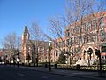
- Queen Square Park: Located right in the middle of Downtown Fredericton.
- Reading Park: A 33-acre park with an open field and a 1.1 km walking trail through an old forest. This forest is one of the last places in the city where pileated woodpeckers live.
- Wilmot Park: A recreational park downtown.
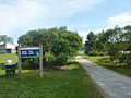
Fredericton's Trail System
Fredericton has a large network of 25 trails, stretching over 85 kilometers (53 miles). These trails are on both sides of the Saint John and Nashwaak Rivers. Many of them are "rail trails," meaning they follow old railway lines. This includes the Fredericton Railway Bridge which crosses the Saint John River for 0.6 kilometers (0.4 miles). Fredericton's rail trails are part of the Sentier NB Trail system and also connect to the larger Trans-Canada Trail network.
City Services
The Fredericton Police Department is in charge of keeping the city safe. It had 115 officers in 2012 and was founded in 1851.
The Fredericton Fire Department has four stations that put out fires in the city.
Learning and Research
The Anglophone West School District and the District Scolaire Francophone Sud (District 1) manage schools in Fredericton. These include Fredericton High School, École des Bâtisseurs, and the École Sainte-Anne. Leo Hayes High School is a school built through a public-private partnership.
Fredericton has two universities: the University of New Brunswick and St. Thomas, which is the province's only Catholic university.
Other colleges include the New Brunswick College of Craft and Design, the New Brunswick Community College, and the Maritime College of Forest Technology. There are also for-profit universities like University of Fredericton and Yorkville University.
The Hugh John Flemming Forestry Centre does research on how to manage forests. Fredericton's Provincial Research Organization focuses on things like fishing, mining, manufacturing, energy, and the environment.
Getting Around Fredericton
You can fly into or out of Fredericton through the Fredericton International Airport.
Fredericton Transit provides bus service seven days a week.
Fredericton started adding bicycle lanes in July 2008 to make it easier to bike around the city.
Passenger train service in Fredericton ended in the 1960s, and freight train service ended in 1996. All the old railway tracks have been removed.
Fredericton is also served by the Maritime Bus company, which connects the city to other places in the Maritimes.
The Trans-Canada Highway runs along the southern edge of the city. Routes 7 and 8 also go through Fredericton. Two highway bridges, the Westmorland Street Bridge and the Princess Margaret Bridge, cross the Saint John River. These bridges connect to major roads that serve the north side of the city.
Images for kids
-

Princess Margaret Bridge
-
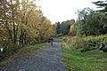
The Nashwaak River Trail
-
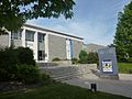
The Beaverbrook Art Gallery, before its 2022 addition
-
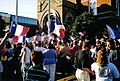
Tintamarre, a celebration of Acadian culture
-
Queen Square Park
-
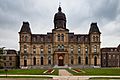
The New Brunswick Legislative Building
-
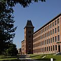
Marysville Place, a government office building
-
Downtown Fredericton
-
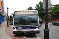
Fredericton Transit bus with a bike rack


.jpg)


See also
 In Spanish: Fredericton para niños
