
Geography of El Salvador facts for kids
El Salvador is a country located in Central America. It's a very active place for earthquakes and volcanoes because it sits where three huge tectonic plates meet. The country also has a warm, tropical climate.
 |
|
| Continent | North America |
|---|---|
| Region | Central America |
| Area | Ranked 148th |
| • Total | 21,041 km2 (8,124 sq mi) |
| • Land | 98.48% |
| • Water | 1.52% |
| Coastline | 307 km (191 mi) |
| Borders | Total border: 590 km (370 mi) |
| Highest point | Cerro El Pital 2,730 metres (8,960 ft) |
| Lowest point | Pacific Ocean 0 metres (0 ft) |
| Longest river | Rio Lempa 422 km (262 mi) |
| Largest lake | Lago de Ilopango 72 km2 (28 sq mi) |
| Exclusive economic zone | 90,962 km2 (35,121 sq mi) |
Contents
Why El Salvador Has Earthquakes and Volcanoes
.jpg)

El Salvador and the rest of Central America are very active with earthquakes and volcanoes. This is because the region sits on top of three large tectonic plates. These are like huge pieces of the Earth's outer layer that are always slowly moving. When they move and rub against each other, they cause earthquakes and volcanic eruptions.
Most of Central America and the Caribbean Basin are on the Caribbean Plate, which doesn't move much. However, the Cocos Plate, which is under the Pacific Ocean, is always moving northeast. The ocean floor is made of a heavy rock called basalt. When it crashes into the lighter rocks of Central America, the ocean floor is forced to slide underneath the land. This creates a very deep ditch in the ocean called the Middle America Trench off the coast of El Salvador.
This sliding motion of the Cocos Plate causes many earthquakes near the coast. As the ocean floor rocks are pushed deeper, they melt. This molten rock then pushes up through weak spots in the Earth's surface, forming volcanoes and geysers (hot springs that shoot water and steam).
North of El Salvador, Mexico and most of Guatemala are on the North American Plate. This plate is moving west and bumps into the northern edge of the Caribbean Plate in southern Guatemala. This grinding action creates a large crack in the Earth's crust, similar to the San Andreas Fault in California. This crack causes earthquakes in northern El Salvador.
El Salvador has a long history of powerful earthquakes and volcanic eruptions. Its capital city, San Salvador, was destroyed in 1756 and 1854. It also suffered a lot of damage in earthquakes in 1919, 1982, and 1986.
The country has over twenty volcanoes. Only two, San Miguel and Izalco, have been active recently. From the early 1800s to the mid-1950s, Izalco erupted so regularly that people called it the "Lighthouse of the Pacific." Its bright flares were easy to see from ships far out at sea. At night, its glowing lava made it look like a bright, shining cone.
El Salvador's Landscape
-
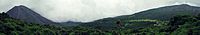
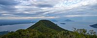
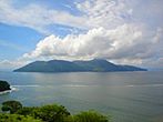
View of Izalco (volcano) and Santa Ana Volcano from Cerro Verde
-
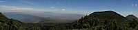
View of Cerro Verde, Izalco (volcano) and Coatepeque Caldera from Santa Ana Volcano
-
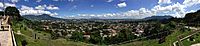
View of San Salvador city and San Salvador (volcano)
-
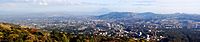
View of San Salvador city from San Salvador (volcano)
-
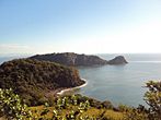
View of Gulf of Fonseca from Conchagua (volcano)
-
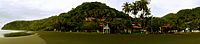
El Balsamar, La Libertad Department (El Salvador)
.jpg)


El Salvador has two mountain ranges that run side-by-side from west to east. Between them is a central flat area called a plateau. Along the Pacific coast, there's a narrow flat area. These features divide the country into two main parts:
- The interior highlands (mountains and central plateau), which cover 85% of the land.
- The Pacific lowlands (coastal plains).
Mountain Ranges
The northern mountain range, called the Sierra Madre, forms a continuous chain along the border with Honduras. These mountains are between 1,600 and 2,700 meters high. This area used to have many forests, but too much logging caused a lot of erosion, making it semi-barren. Because of this, it's the least populated part of the country, with little farming.
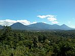
The southern mountain range is actually a broken chain of more than twenty volcanoes, grouped into five areas. The westernmost group, near the Guatemalan border, includes Izalco and Santa Ana. Santa Ana is the highest volcano in El Salvador, at 2,365 meters. Between these volcanoes are flat areas and rolling hills made from old ash. The soil from the volcanoes is very rich, and much of El Salvador's coffee is grown on these slopes.
Central Plateau and Coastal Plains
The central plateau makes up only 25% of the land. However, it's where most of the people live, and it has the country's largest cities. This flat area is about 50 kilometers wide and sits about 600 meters above sea level. The land here is gently rolling, with some steep slopes, lava fields, and geysers.
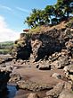
A narrow plain stretches from the coastal volcanoes to the Pacific Ocean. This area varies in width from one to thirty-two kilometers. It's widest in the east, next to the Golfo de Fonseca. Near La Libertad, the mountains come right down to the ocean, making the lowlands very narrow. The surfaces in the Pacific lowlands are generally flat or gently rolling. They are formed by deposits from nearby slopes.
Rivers and Lakes
El Salvador has over 300 rivers. The most important one is the Rio Lempa. It starts in Guatemala, flows through the northern mountains, along much of the central plateau, and then cuts through the southern volcanoes to reach the Pacific. It's the only river in El Salvador that boats can travel on. The Rio Lempa and its smaller rivers drain about half of the country. Other rivers are usually short and flow from the central plateau to the Pacific.
Many lakes formed by volcanoes are found in the interior highlands. Many of these lakes are surrounded by mountains with high, steep banks. The largest lake, Lago de Ilopango, is just east of the capital city. Other big lakes include Lago de Coatepeque in the west and Lago de Güija on the Guatemalan border. The Cerrón Grande Hydroelectric Dam on the Rio Lempa has created a large reservoir called Embalse Cerron Grande in northern El Salvador.
Izalco volcano has erupted at least 54 times since 1770. It was nicknamed "Lighthouse of the Pacific" because its eruptions acted like a beacon for ships at night.
-
Cordillera de Apaneca
-
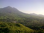
San Vicente (volcano)


.jpg)


El Salvador's Climate
-
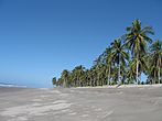
Corral de Mulas beach, Usulutan
-
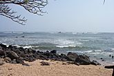
Los Cobanos beach in Sonsonate
-
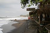
Sunzal beach, La Libertad, La Libertad
-
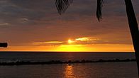
Pacific sunset at Salinitas beach Sonsonate
-
Meanguera island Gulf of Fonseca
-
Meanguera del Golfo
-
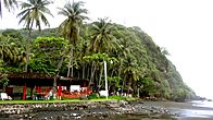
El Balsamar, La Libertad Department (El Salvador)
-
El Sunzal beach in La Libertad, La Libertad
-
El Zonte Beach


.jpg)

_-_panoramio.jpg)

El Salvador has a tropical climate with clear wet and dry seasons. Temperatures mostly change with how high up a place is, not much with the time of year. The Pacific lowlands are always hot and humid. The central plateau and mountain areas have more moderate temperatures.
Wet and Dry Seasons
The rainy season, called invierno (winter) by locals, lasts from May to October. Almost all the yearly rain falls during this time. On mountain slopes facing south, the yearly rainfall can be as high as 2,000 millimeters (about 79 inches). Areas that are more protected and the central plateau get less rain, but still a lot. Rain during this season usually comes from low pressure systems over the Pacific. It often falls in heavy thunderstorms in the afternoon. While hurricanes sometimes form in the Pacific, they rarely hit El Salvador directly. Notable exceptions include Hurricane Mitch in 1998 and Hurricane Emily in 1973.
From November to April, the northeast trade winds control the weather. During these months, air coming from the Caribbean loses most of its moisture as it passes over the mountains in Honduras. By the time this air reaches El Salvador, it is dry, hot, and hazy. This season is known as verano (summer).
Temperatures
Temperatures don't change much with the seasons. How high up a place is, is the main factor. The Pacific lowlands are the hottest region, with average yearly temperatures from 25 to 29 degrees Celsius (77 to 84 degrees Fahrenheit). San Salvador is typical of the central plateau, with an average yearly temperature of 23 degrees Celsius (73 degrees Fahrenheit). Its highest recorded temperature was 38 degrees Celsius (100 degrees Fahrenheit), and its lowest was 6 degrees Celsius (43 degrees Fahrenheit). Mountain areas are the coolest, with average yearly temperatures from 12 to 23 degrees Celsius (54 to 73 degrees Fahrenheit). Minimum temperatures there can sometimes get close to freezing.
| Climate data for San Salvador (Ilopango International Airport) 1981-2010, extremes 1957-present | |||||||||||||
|---|---|---|---|---|---|---|---|---|---|---|---|---|---|
| Month | Jan | Feb | Mar | Apr | May | Jun | Jul | Aug | Sep | Oct | Nov | Dec | Year |
| Record high °C (°F) | 36.0 (96.8) |
36.1 (97.0) |
37.2 (99.0) |
38.4 (101.1) |
36.7 (98.1) |
34.6 (94.3) |
34.5 (94.1) |
35.1 (95.2) |
33.3 (91.9) |
35.6 (96.1) |
35.3 (95.5) |
35.7 (96.3) |
38.4 (101.1) |
| Mean daily maximum °C (°F) | 30.8 (87.4) |
32.0 (89.6) |
32.7 (90.9) |
32.7 (90.9) |
31.1 (88.0) |
30.1 (86.2) |
30.3 (86.5) |
30.5 (86.9) |
29.5 (85.1) |
29.5 (85.1) |
29.9 (85.8) |
30.2 (86.4) |
30.8 (87.4) |
| Daily mean °C (°F) | 22.8 (73.0) |
23.6 (74.5) |
24.2 (75.6) |
25.0 (77.0) |
24.6 (76.3) |
23.9 (75.0) |
23.9 (75.0) |
23.9 (75.0) |
23.3 (73.9) |
23.3 (73.9) |
23.0 (73.4) |
22.8 (73.0) |
23.7 (74.7) |
| Mean daily minimum °C (°F) | 16.9 (62.4) |
17.6 (63.7) |
18.4 (65.1) |
19.8 (67.6) |
20.4 (68.7) |
20.0 (68.0) |
19.5 (67.1) |
19.7 (67.5) |
19.6 (67.3) |
19.3 (66.7) |
18.4 (65.1) |
17.5 (63.5) |
18.9 (66.0) |
| Record low °C (°F) | 11.9 (53.4) |
12.0 (53.6) |
13.0 (55.4) |
12.0 (53.6) |
12.0 (53.6) |
15.5 (59.9) |
13.5 (56.3) |
12.2 (54.0) |
15.0 (59.0) |
12.5 (54.5) |
11.1 (52.0) |
12.0 (53.6) |
11.1 (52.0) |
| Average rainfall mm (inches) | 1 (0.0) |
2 (0.1) |
10 (0.4) |
36 (1.4) |
176 (6.9) |
279 (11.0) |
355 (14.0) |
319 (12.6) |
338 (13.3) |
208 (8.2) |
53 (2.1) |
9 (0.4) |
1,786 (70.4) |
| Average rainy days (≥ 0.1 mm) | 1 | 1 | 1 | 5 | 13 | 20 | 20 | 20 | 20 | 16 | 4 | 2 | 123 |
| Average relative humidity (%) | 67 | 66 | 67 | 72 | 80 | 83 | 82 | 83 | 86 | 83 | 76 | 72 | 77 |
| Mean monthly sunshine hours | 301 | 277 | 294 | 243 | 220 | 174 | 239 | 257 | 180 | 211 | 267 | 294 | 2,957 |
| Source 1: Ministerio de Medio Ambiente y Recursos Naturales | |||||||||||||
| Source 2: Danish Meteorological Institute (precipitation days and sun 1931–1960), Meteo Climat (record highs and lows) | |||||||||||||
| Climate data for Santa Ana, El Salvador (1981–2010) | |||||||||||||
|---|---|---|---|---|---|---|---|---|---|---|---|---|---|
| Month | Jan | Feb | Mar | Apr | May | Jun | Jul | Aug | Sep | Oct | Nov | Dec | Year |
| Record high °C (°F) | 33.5 (92.3) |
35.7 (96.3) |
37.0 (98.6) |
36.0 (96.8) |
35.4 (95.7) |
33.8 (92.8) |
32.7 (90.9) |
33.6 (92.5) |
32.3 (90.1) |
32.5 (90.5) |
32.5 (90.5) |
33.5 (92.3) |
37.0 (98.6) |
| Mean daily maximum °C (°F) | 30.8 (87.4) |
32.1 (89.8) |
33.7 (92.7) |
34.1 (93.4) |
32.3 (90.1) |
30.9 (87.6) |
31.1 (88.0) |
31.1 (88.0) |
30.3 (86.5) |
30.1 (86.2) |
30.0 (86.0) |
30.3 (86.5) |
31.4 (88.5) |
| Daily mean °C (°F) | 23.7 (74.7) |
24.6 (76.3) |
25.7 (78.3) |
26.6 (79.9) |
26.2 (79.2) |
25.3 (77.5) |
25.3 (77.5) |
25.3 (77.5) |
24.7 (76.5) |
24.5 (76.1) |
24.0 (75.2) |
23.8 (74.8) |
25.0 (77.0) |
| Mean daily minimum °C (°F) | 16.3 (61.3) |
17.0 (62.6) |
17.7 (63.9) |
18.9 (66.0) |
19.6 (67.3) |
19.5 (67.1) |
19.2 (66.6) |
19.3 (66.7) |
19.1 (66.4) |
19.0 (66.2) |
17.8 (64.0) |
16.9 (62.4) |
18.4 (65.1) |
| Record low °C (°F) | 11.0 (51.8) |
8.0 (46.4) |
11.6 (52.9) |
13.0 (55.4) |
14.5 (58.1) |
13.0 (55.4) |
15.0 (59.0) |
15.5 (59.9) |
15.4 (59.7) |
15.0 (59.0) |
12.5 (54.5) |
10.0 (50.0) |
8.0 (46.4) |
| Average precipitation mm (inches) | 2 (0.1) |
6 (0.2) |
8 (0.3) |
57 (2.2) |
188 (7.4) |
322 (12.7) |
297 (11.7) |
313 (12.3) |
315 (12.4) |
185 (7.3) |
38 (1.5) |
13 (0.5) |
1,745 (68.7) |
| Average relative humidity (%) | 66 | 63 | 63 | 64 | 73 | 80 | 77 | 78 | 82 | 78 | 72 | 68 | 72 |
| Mean monthly sunshine hours | 310.0 | 271.2 | 291.4 | 258.0 | 254.2 | 198.0 | 263.5 | 260.4 | 204.0 | 229.4 | 267.0 | 303.8 | 3,110.9 |
| Mean daily sunshine hours | 10.0 | 9.6 | 9.4 | 8.6 | 8.2 | 6.6 | 8.5 | 8.4 | 6.8 | 7.4 | 8.9 | 9.8 | 8.5 |
| Source 1: Ministerio de Medio Ambiente y Recursos Naturales | |||||||||||||
| Source 2: Deutscher Wetterdienst (precipitation days and sun) | |||||||||||||
| Climate data for San Miguel, El Salvador (1981–2010) | |||||||||||||
|---|---|---|---|---|---|---|---|---|---|---|---|---|---|
| Month | Jan | Feb | Mar | Apr | May | Jun | Jul | Aug | Sep | Oct | Nov | Dec | Year |
| Mean daily maximum °C (°F) | 36.9 (98.4) |
38.0 (100.4) |
38.4 (101.1) |
38.6 (101.5) |
36.2 (97.2) |
34.4 (93.9) |
34.9 (94.8) |
34.9 (94.8) |
33.9 (93.0) |
33.2 (91.8) |
34.2 (93.6) |
35.6 (96.1) |
35.7 (96.3) |
| Daily mean °C (°F) | 27.6 (81.7) |
28.4 (83.1) |
29.5 (85.1) |
30.6 (87.1) |
29.8 (85.6) |
28.6 (83.5) |
28.5 (83.3) |
28.5 (83.3) |
27.9 (82.2) |
27.6 (81.7) |
27.4 (81.3) |
27.3 (81.1) |
28.5 (83.3) |
| Mean daily minimum °C (°F) | 18.3 (64.9) |
18.9 (66.0) |
20.5 (68.9) |
22.7 (72.9) |
23.3 (73.9) |
22.8 (73.0) |
22.2 (72.0) |
22.2 (72.0) |
22.3 (72.1) |
22.0 (71.6) |
20.6 (69.1) |
19.0 (66.2) |
21.2 (70.2) |
| Average precipitation mm (inches) | 1 (0.0) |
1 (0.0) |
6 (0.2) |
24 (0.9) |
207 (8.1) |
239 (9.4) |
212 (8.3) |
255 (10.0) |
321 (12.6) |
210 (8.3) |
59 (2.3) |
7 (0.3) |
1,544 (60.8) |
| Average relative humidity (%) | 59 | 57 | 57 | 62 | 71 | 77 | 75 | 76 | 81 | 81 | 73 | 64 | 70 |
| Source: Ministerio de Medio Ambiente y Recursos Naturales | |||||||||||||
Quick Facts About El Salvador
-
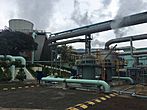
Geothermal power plant in Ahuachapan Department
-
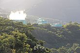
Geothermal power center in the Usulután Department
-
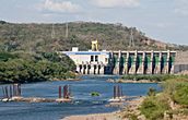
Central Hydroelectricity dam over the Lempa River


El Salvador covers a total area of 21,041 square kilometers. This includes 20,721 square kilometers of land and 320 square kilometers of water. To give you an idea, El Salvador is about the same size as Israel or the U.S. states of New Jersey and Vermont. However, its population size is similar to that of Libya or Lebanon.
The country shares 590 kilometers of borders with other nations:
El Salvador also has a coastline that stretches for 307 kilometers along the Pacific Ocean.
Maritime Claims and Resources
El Salvador claims a territorial sea that extends 200 nautical miles (about 370 kilometers) from its coast.
The country has several important natural resources:
- Hydropower (electricity from water)
- Geothermal power (electricity from Earth's heat)
- Petroleum (oil)
- Arable land (land good for farming)
In 2012, about 34% of the land was used for growing crops, and 10.86% for permanent crops like fruit trees. The rest, about 55%, was used for other purposes. About 450 square kilometers of land were irrigated in 2003, meaning water was supplied to help crops grow. El Salvador has about 25 cubic kilometers of fresh water available each year (2011 data).
Natural Hazards
El Salvador is often called the "Land of Volcanoes." It experiences frequent and sometimes very destructive earthquakes and volcanic activity. While hurricanes can form in the Pacific, they rarely make a direct hit on El Salvador.
Extreme Points of El Salvador
These are the furthest points in each direction:
- Northernmost point: North of El Limo, in the Santa Ana Department
- Southernmost point: El Jaguey, in the La Unión Department
- Westernmost point: Border with Guatemala, in the Ahuachapán Department
- Easternmost point: The island of Meanguera del Golfo, in the La Unión Department
- Highest point: Cerro El Pital, at 2,730 meters (8,957 feet) above sea level
- Lowest point: The Pacific Ocean, at 0 meters (sea level)
Environmental Concerns
El Salvador faces some environmental challenges:
- Deforestation (cutting down too many trees)
- Soil erosion (soil being washed or blown away)
- Water pollution
- Contamination of soils from harmful waste
El Salvador is part of several international agreements to protect the environment, including:
- Convention on Biological Diversity
- United Nations Framework Convention on Climate Change
- Kyoto Protocol to the United Nations Framework Convention on Climate Change
- United Nations Convention to Combat Desertification
- CITES (Convention on International Trade in Endangered Species)
- Basel Convention (on hazardous wastes)
- Partial Test Ban Treaty
- Montreal Protocol (on ozone-depleting substances)
- Ramsar Convention (on wetlands)
El Salvador has signed, but not yet fully agreed to, the United Nations Convention on the Law of the Sea.
See also
 In Spanish: Geografía de El Salvador para niños
