Geology of New Jersey facts for kids
New Jersey is a state with many different kinds of land and rocks. It has tall mountains like the Appalachian Mountains and Highlands in the northwest. It also has flat areas like the Atlantic Coastal Plain, which includes the sandy Pine Barrens and the famous Jersey Shore. The way the land is shaped has affected how people settled, built towns, and created businesses for hundreds of years.
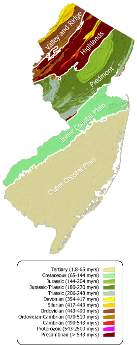
New Jersey is divided into four main land regions, called physiographic provinces. From south to north, these are: the Atlantic Coastal Plain, the Piedmont, the Highlands, and the Ridge and Valley.
Contents
The Coastal Plain: Beaches and Pine Forests

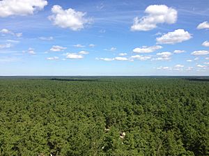
This is the biggest land region in New Jersey. It covers the southeastern part of the state. It stretches from Trenton to Carteret. This area is made of a thick layer of loose sand, clay, and gravel. These materials were laid down since the Cretaceous Period, which was about 145 to 66 million years ago. These layers continue out into the Atlantic Ocean under the water.
The land here is mostly flat. There are a few small hills made of harder sand or gravel. This region has three smaller parts. One is the Lowland section, which is flat and often covered by water. It includes marshes, back bays, and barrier islands along the coast.
The next part is the intermediate upland section. This area is higher and better for farming. The sand from the coastal plain has been dug up for making glass and metal molds. Finally, the upland section is home to the New Jersey Pine Barrens and Fort Dix. You can often find a green mineral called Glauconite here, especially near Freehold Township, New Jersey.
The Piedmont: Rolling Hills and Basalt Rocks
Most of the rocks in this region are part of a large group called the Newark Supergroup. These include different types of rock formations like the Passaic Formation and the Stockton Formation. You'll also find igneous rocks here, which are formed from cooled lava. The most common ones are basalt and diabase.
In New Jersey, there are several basalt flows, like the Hook Mountain Basalt. A famous example of diabase is the Palisades Sill along the Hudson River. These rocks formed when the supercontinent Pangea started to break apart. This happened during the Triassic and Jurassic Periods, from about 252 to 145 million years ago. Much of the northern part of this region was shaped by glaciers. This helped create the harbors of New York and Newark.
A small part of the Pennsylvania Piedmont, called the Trenton Prong, reaches into New Jersey near Trenton. It has very old rocks, some from over 540 million years ago. You can also find the Manhattan schist rock in New Jersey. It is mostly under New York harbor and near Bayonne and Jersey City.
The Highlands: Ancient Mountains and Minerals
The Highland region is made of what's left of a mountain range that was formed about a billion years ago. This ancient mountain range stretched from Newfoundland to Mexico. It was created during an event called the Grenville Orogeny, which was a huge collision of landmasses.
This area has some of the oldest rocks in New Jersey. It's mostly a mix of very old Pre-Cambrian granites and gneisses. These are very hard rocks that resist erosion, forming steep hills and mountains. There are also younger Paleozoic clastic and carbonate rocks.
The Highlands are known for their rich mineral deposits. Many mines, both active and abandoned, can be found here. Important minerals like iron, zinc, and marble were all dug up from this region. A special mineral called Franklinite was first found at the Sterling Hill Mine in this area.
The Ridge and Valley: Glaciers and Gaps
This is the smallest land region in New Jersey. It's located in the very northwest corner of the state. The Kittatinny Valley is part of a much larger valley system called the Great Appalachian Valley. It contains some of the oldest rocks in this region, like the Matinsburg shale, formed during the Ordovician period.
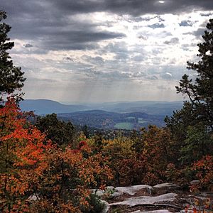
Next to this valley is the Kittatinny Ridge, which is a long mountain ridge. It rises from 1,500 to 1,800 feet high. This ridge runs in a northeast-southwest direction. Beyond this ridge, there are rolling hills and smaller ridges made of rocks from the Silurian and Devonian periods.
The Kittatinny Ridge formed about 400 million years ago. This happened when a small, thin continent crashed into what would become North America. This collision caused the rocks to fold and break. This pushed up the Silurian Shawnagunk conglomerate, which is mostly made of quartz. Over millions of years, rain, wind, snow, and ice shaped the mountains and valleys we see today.
The Wisconsin glacier, which started forming around 21,000 BC, also left its mark. When it melted around 13,000 BC, it left behind large fields of boulders and piles of rock and dirt called moraines.
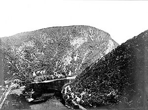
The Delaware River flows through this region. It is guided by the ridges and generally flows southwest. The river also passes through the Delaware Water Gap in Kittatinny Mountain. This is a famous spot where the river cuts through the mountain. The rocks in this area also show karst topography. This means there are features like sinkholes and small caves formed by water dissolving limestone.
Cool Geologic Features
- Delaware Water Gap
- New Jersey Palisades
- Sterling Hill
Important Rock Formations
- Lockatong Formation
- Passaic Formation (used to be called Brunswick Formation)
- Stockton Formation
- Marcellus Formation


