
Granite, Colorado facts for kids
Quick facts for kids
Granite, Colorado
|
|
|---|---|

Granite as viewed from U.S. Route 24, across the Arkansas River.
|
|

Granite, Colorado
Location in Colorado
|
|
| Country | |
| State | |
| Counties | Chaffee |
| Elevation | 9,059 ft (2,761 m) |
| Time zone | UTC-7 (MST) |
| • Summer (DST) | UTC-6 (MDT) |
| ZIP code |
81228
|
| GNIS feature ID | 180420 |
Granite is a small, unincorporated community in Chaffee County, Colorado, United States. It has its own U.S. Post Office with the zip code 81228. Granite sits high in the mountains, right on the Arkansas River. It's located between the Mosquito Range and the Sawatch Range. This puts it close to some of the tallest mountains in the contiguous United States, like Mount Elbert and Mount Massive.
Granite has a long history, starting as a mining camp during the Pike's Peak Gold Rush. It even used to be the county seat for a while. Early gold seekers, like Horace Tabor, were drawn to this area.
Contents
Exploring Granite's Location and Weather

Granite is positioned right in the middle of Leadville to the north and Buena Vista to the south. The Arkansas River flows through Granite. This river was once a busy spot for placer mining during the Colorado Gold Rush. The Arkansas River is the sixth longest river in the US. Its starting point, called the headwaters, is about 17 miles north, near Leadville.
Granite is surrounded by two mountain ranges. The Mosquito Range is to the east, and the Sawatch Range is to the west. It's also very close to two of the highest peaks in the contiguous United States. To the northwest is Mount Elbert, the tallest of the "fourteeners" (mountains over 14,000 feet) in the Sawatch Range. It's the second highest peak in the contiguous US. Nearby Mount Massive is the third highest.
Independence Pass, which is 12,100 feet (3,687 meters) high, is close by. It's the highest paved road crossing the Continental Divide in the United States. Because Granite is so high up, at 9,012 feet (2,747 meters), it has cool summers and very cold winters. Winter temperatures can often drop to -25 or -30 degrees. Even though it's surrounded by mountains that block moisture, it gets deep winter snows.
Granite's Gold Rush Beginnings

The Pike's Peak Gold Rush started in 1859. This event brought many people to the Colorado Territory. Some of the first gold discoveries in Colorado were placer deposits. These were found near the start of the Arkansas River, in a place called Oro City. In 1860, Cache Creek, a mining camp near Granite, became an important settlement. It had about 300 people. By the next year, its population grew to 3,000!
After gold was found in Low Pass Gulch in 1867, the town of Granite grew. It was located on both sides of the Arkansas River. Many miners from Cache Creek moved to Granite. The settlement covered a three-mile stretch of the river. One mining claim even went two miles up Cache Creek. In 1867, free quartz gold was discovered, and a mill was built. In 1868, Granite became the county seat. This meant it was the main town for the county.

One famous early gold seeker was Horace Tabor. He later moved to Leadville, where he became very rich during the Colorado Silver Boom in 1879. Tabor married Elizabeth "Baby Doe" McCourt, who was much younger than him. They had two children, Lily and Silver Dollar. The Tabors lost their money when silver prices fell in 1893. Horace Tabor died in 1899. Baby Doe lived simply in a shed at their silver mine for thirty years. She was found there after she passed away in 1936.

Until 1879, Granite was part of Lake County. This was one of the two biggest counties in the Colorado Territory. Granite was the county seat because it had rich gold placer strikes. But in 1878, booming, silver-rich Leadville, 17 miles north, took over as the county seat.
However, Granite still managed to be a county seat. New county lines were drawn, creating Chaffee County. Granite became its county seat. But a year later, an election was held. Buena Vista, 17 miles south of Granite, won with 1,128 votes. At that time, the total population was 1,200, and women could not vote. Granite said the election was unfair and refused to give up its position. So, one night, a group of men from Buena Vista decided to take action.
The Buena Vista Heritage Museum tells the story: "Buena Vistans voted to make their town the county seat, but Granite refused to give up the records. So a group of men led by Ernest Wilbur 'borrowed' a locomotive and flat car and went up to Granite late on the night of November 12, 1880. The men built a siding to the Granite Courthouse and kicked in the door. Sheriff John Mear and his wife investigated the noise and were forced at gunpoint to watch the removal of all the county records by the Buena Vista men. Furniture was unbolted from the floor, including the railing. Even the heat stove, with embers remaining in it from the day's use, was loaded onto the flatcar."
Gold and Geology in Granite

The upper Arkansas River valley, where Granite is, is surrounded by tall, steep rock cliffs. These cliffs are made of pink-colored Precambrian granite. Granite is in the middle of the Colorado Mineral Belt (CMB). This is a 50-mile-wide strip that runs north and south for 300 miles. Minerals in the CMB came mostly from molten rock (magma) that pushed up from deep underground. The main minerals found were mixed metal sulfide minerals. These included pyrite, galena, sphalerite, chalcopyrite, and also gold, silver, and copper. During the last glacial period, natural gold was freed from the rock. It was then deposited along the ancient, much larger Arkansas River bed. This river was bigger back then because of melting glaciers.


Unlike the early days of the California Gold Rush, very few large gold nuggets were found in Colorado. A gold pan was good for finding "pay dirt" (gold-rich soil). But to get more gold, miners built sluice boxes. These boxes helped separate gold dust from gravel. They were built on site from available materials and placed in the river current.
Gold-filled gravel was shoveled into the top of the sluice. Water flowed through the box, carrying the lighter gravel away. But the heavier gold flakes would settle and get caught by raised parts inside the box. You can still see signs of placer mining along the Arkansas River near Granite. There are many piles of rounded granite boulders. These rocks were once buried in the gravel left by glaciers.
Some of the first gold discoveries in the Colorado gold rush were placer deposits. These were found in 1859 at the start of the Arkansas River near Granite. By late 1860, most streams had been explored. Many gold placers were found along the Arkansas River, all the way to Buena Vista. The deposits near Granite, along the Arkansas River and Cache Creek, were probably the most productive. They produced about 49,000 troy ounces of gold.

In many Colorado mining areas, easily found placer gold was the first big discovery. But the supply of free gold in stream beds quickly ran out. So, miners then looked for veins of lode gold. This was the original source of the placer gold. The hills above Granite are full of old mining tunnels from hard rock mining. This shows the second stage of a gold rush. Miners in nearby Leadville found silver, leading to a silver rush. But Granite's gold began to run out in just a few years. The town's population, once as high as 7,000, started to shrink.
Travel by Stagecoach and Train
The Leadville Stagecoach Road
In the early days, settlers in Granite and the surrounding area traveled by horseback or with pack mules and burros. The Santa Fe Trail, built in 1822, had a path that went north to Denver (founded in 1858). By 1877, the Leadville Stagecoach Road was running. It went from Canyon City, through Granite, to Leadville, and then north to Denver.
Having reliable transportation was important for bringing supplies to the growing towns. This route was used more for supplies and mail than for passengers. An old schedule from 1880 shows the trip from Canyon City to Leadville was 126 miles. It took 26 bumpy hours. Today, the distance is 120 miles. This shows that in these high mountains, there are only a few ways to travel. But with modern cars, the trip now takes only about two hours. The fare to Granite was $13.50. The stagecoach from Canyon City to Leadville ran three times a day.
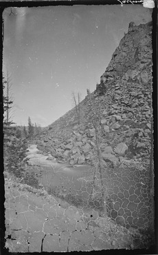
You can still see parts of the old stage road today. There are also remains of bridges that once crossed the Arkansas River. These are north of Buena Vista, near the Colorado Midland Railway tunnels. One crossing was from east to west at Pine Creek (called "La Plata" in the old photo). The last crossing was to the east side of the Arkansas, just north of Clear Creek, about a mile south of Granite. When the water is low, you can still see log supports of the old bridge at the Clear Creek crossing. The photo on the right was taken for the United States Geological and Geographical Survey of the Territories. This was the first big geological survey of the American West. Pine Creek, now known as Pine Creek, is famous among rafters for its dangerous rapids.
The stage road was built 10 to 15 years before the railroads. It's likely that the well-built rail routes took over from the hand-built stage road. It's not clear if the stage road was abandoned as soon as railroads reached Leadville. Or if it continued to be used by wagons and early cars until better roads were built on the west side of the river, where Highway 24 is now. The part of the old stage road that goes through Granite is surprisingly well-preserved. It is now used as a hiking and cycling trail.
Denver & Rio Grande Western Railroad
.jpg)
In 1870, the Denver Pacific Railroad was built. This gave Denver a train connection to Cheyenne, Wyoming. Train tracks were quickly being laid in southern Colorado. The Denver & Rio Grande Western and the Atchison, Topeka & Santa Fe railroads were competing. They wanted to control the newly found mineral and coal deposits, as well as ranching and farming areas.
But the 1878 silver boom in Leadville changed everything. By 1879, everyone was rushing to Leadville, 17 miles north of Granite. With the boom, Leadville quickly became the third largest city in Colorado. The new millionaires had money and wanted to spend it. They also needed to transport their silver ore to smelters in Denver or southern Colorado. They also needed coal from southern coal mines to power smelters, blacksmith and machine shops, and assay offices. Without local coal, they were using charcoal as fuel. The charcoal industry in Leadville employed about 3,000 people. This was three times more than those working in the mines. The forests were quickly being used up.
Both the D&RG and the Santa Fe wanted to control Leadville's new riches. They both quickly laid tracks. But when they reached the Grand Canyon of the Arkansas (Royal Gorge), there wasn't enough room for both of them. Over a hundred years later, the D&RG said on their website: "The Royal Gorge Route has, quite possibly, one of strangest histories of the entire Rio Grande system." You can read about the "Royal Gorge War" in the Royal Gorge Route Railroad Wikipedia article.
After months of legal arguments, construction started again. The D&RGW reached Granite and then Leadville on July 20, 1880. The train line was narrow gauge until 1888. Then it became one of the first routes changed to dual gauge. This was partly to handle the heavy freight coming from Leadville. But it was mainly to provide a standard gauge route west. This helped them compete better with the growing Colorado Midland.
Colorado Midland Railway
The Colorado Midland Railway started in 1883. It was the first standard gauge railroad built over the Continental Divide in Colorado. It ran from Colorado Springs through Granite and Leadville. It crossed the divide at Hagerman Pass. Then it went on to Aspen and Grand Junction.
They had a harder time laying their tracks. This was because the easiest places to build rails were already taken by other railroads. The second problem was that the Colorado Midland was a standard gauge. This meant it needed more space for the tracks. Curves had to be wider, and bridges and tunnels had to be larger. The total cost was much higher. There was a two-story train station in both Granite and Leadville. Leadville also had a roundhouse for trains.
Old photos from March and April 1887 show crews laying track in Granite. Records show that the railroad reached Leadville in August. Passenger and freight service started the next day.
The CM served Leadville’s mines and smelters until 1906. Its tracks went into Iowa Gulch and California Gulch, areas now called the Leadville mining district. Service stopped in 1918 because of money problems. You can still see parts of the old Midland grade in Granite. Sections of a bridge can be seen about two miles south. This is where the track crossed to the west side of the river at Clear Creek. Evidence of the old bridge is still visible to hikers. Four tunnels still exist farther south, closer to Buena Vista.
Ghost Towns Near Granite

Granite is not as busy as it once was, but it has survived. It still has a highway running through it. However, many old ghost towns remain in the hills around Granite. As prospectors searched for gold, every stream flowing into the Arkansas River was a possible gold mining site. It was a chance to get rich.
About two miles south of Granite, Clear Creek flows into the Arkansas River. People started looking for gold here as early as 1867. A gravel bar reaching into the Arkansas was found to be rich in placer gold. But the real activity didn't start until 1879. That's when the canyon became very busy with mines everywhere.
An early report from that time said: "The Free Republic [mine] was the first mine found in this area. It was discovered in July 1879. A tunnel has been dug 85 feet. It shows 3 feet of mineral at the end, with galena and copper. Tests showed 10 to 131 ounces of gold. For 49 feet, the tunnel went through a block of rock with no minerals. But then the valuable vein was found, and it was almost 20 feet wide." This report also listed the colorful names of mines from that time: The Mint, Prince Albert, Thunderbolt, Sixteen String Jack, Sunrise, Bluebird, Siamese Chief, Minnehaha, Silver Crop, Cinderella, Birdie Boy, and Terrible. A later report said the four main mines were the Tasmania, the Fortune, the Banker, and the Swiss Boy. This suggests that most mines did not "pan out" (produce much gold).
The towns of Beaver City, Vicksburg, Rockdale/Silverdale, Winfield, Hamilton, and others, were once very active. Now, they have either completely disappeared or are mostly ghost towns with only a few buildings left.

Winfield was the largest settlement. In 1890, its population was estimated at 1,500. But hundreds more likely lived nearby. Winfield had three saloons, three stores, a post office, two hotels, a boarding house, a mill, a smelter, an ore concentrator, a church, and a school. The last ore was taken out by stagecoach in 1918. Several restored buildings remain, including the school.


Vicksburg was founded in 1867. This happened after gold seekers from Leadville, camping in Clear Creek Canyon, lost their burros. When the miners found their pack animals, they also discovered gold in the creek bed. In its busiest time, Vicksburg had a post office, school, blacksmith, two hotels, two billiard halls, several saloons, a general store, an assay office, and a livery stable. Early miners brought in Balm of Gilead (balsam poplar) trees on burro backs. They planted them to line the street. The early settlers likely used the sticky sap from these trees to make a healing salve for both animals and people. The trees still stand today. They are watered by ditches leading from Vicksburg Creek into the town. These ditches were dug on both sides of the street to provide water. Wooden boxes were built in the ditches to keep food cold and provide water to fight fires. A daily stagecoach ran from Vicksburg to Granite. The fare was $1.50.
Near Vicksburg, but from the 1930s, is the Crescent Moly Mine #100 and Mining Camp. This was not a gold mine. It was connected to the molybdenum boom and the nearby Climax mine. Vicksburg, Winfield, and the Crescent Moly Mine are listed on the National Register of Historic Places.
A mile further down the valley, Pine Creek flows into the Arkansas. There are also signs of gold seeking and mining in this area. The Colorado Historical Society lists the Littlejohn mine camp on the north bank of Pine Creek:
- North bank of Pine Creek, near Granite
- National Register 12/27/1978, 5CF.138
- Located in the Pine Creek mining district, buildings in the complex include a cabin, a burro shed/bunk house, a forge, and other small buildings. All date from the 1880s. They are built of hand-cut logs with special corner joints. The roofs were low-pitched and made of logs, mud, dirt, and grass. Such well-preserved examples of early log mining camps are rare. Many were quickly left or replaced with wood or stone buildings. Harry Littlejohn, who bought the property in 1920, lived and worked there until he died in 1952. He is given credit for keeping the complex in good condition.
Granite Cemetery
The Granite Cemetery, also known as the Cache Creek Cemetery, is about one and a half miles west of Granite. The first known burial is said to be a 19-year-old male who died of pneumonia in 1860. The first marked grave is from 1878. The cemetery is still used today.
Several graves hold the remains of the last old-time miners who lived in the hills around Granite. Charles Franklin was born in Sweden in 1868 and came to the U.S. in 1888. He died in 1950. People called him "Old Man Franklin." He lived in a one-room log cabin with a dirt floor. It was located on the Arkansas River near Clear Creek, just south of Granite. Like others of his kind, he was never married and lived alone. The next year, Frank Churchill, another unmarried miner, was found dead near his cabin in Clear Creek. It took some time for his body to be found.
Dave Jardine, another old miner, lived in a log cabin on Pine Creek, south of Granite. He lived there until he died in 1953. Jardine always carried a "doodlebug." This was a pendulum like those used for dousing. He used it to tell the future or get advice. Dave, or "Stinky Dave" as he was called, loved dogs. He had five or six stray dogs that he kept in his cabin at night.

Granite Today
.JPG)

Not much is left of Granite's past. In the 1950s, a Colorado couple ran a gold panning tourist spot. They called it "Gold Camp." It was just south of town, where Pine Creek meets the Arkansas. By 1955, the Granite school had only thirteen students and closed down. The railroad stopped service in the 1980s.
Chaffee County lists the old school and the Denver & Rio Grande railroad building as historical sites. Several other old buildings still stand. These include a blacksmith-livery, a hotel, and a stage stop.
Today, this area attracts whitewater rafting fans. The rapids were formed by a huge glacial flood. This flood spread boulders down the river for over fifty miles. The whitewater area begins in the "Granite Gorge" with Class IV rapids. The river quickly drops to its steepest point at "Pine Creek Rapids," which are Class V.
Granite is located within the San Isabel National Forest. It is surrounded by three wilderness areas. This makes it a popular place for hiking. The Mount Massive Wilderness area is a few miles north. The Buffalo Peaks Wilderness is to the east, in the Mosquito Range. The Collegiate Peaks Wilderness is to the west, in the Sawatch Range.
The Cache Creek area is still interesting to modern-day gold seekers. They look for the placer gold that was left behind when mining stopped in 1911. The Bureau of Land Management manages Cache Creek. They protect it for wildlife, wetlands, open space, and small-scale placer mining.
For many years, only one business stayed open: the Granite General Store. However, it closed in 2007. The building was originally an 1880s bunkhouse for railroad workers. Currently, there are only eight people living in Granite year-round. Most people, even locals, drive through Granite without knowing its rich history.
Images for kids
-
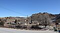
Granite as viewed from U.S. Route 24, across the Arkansas River.
