History of Cheshire facts for kids
The history of Cheshire goes way back, even before humans as we know them lived there! Scientists have found old tools from about 400,000 years ago, showing that early humans were around. Later, during the Stone Age, people started living in Cheshire more permanently. By the Iron Age, the area was home to Celtic tribes like the Cornovii.
The Romans took over Cheshire for almost 400 years, starting in 70 AD. They built a big town and fort called Deva Victrix, which is now the city of Chester. After the Romans left, Cheshire became part of Mercia, an Anglo-Saxon kingdom. This period saw attacks from the Welsh and Danes. In 1070, the Norman Conquest brought harsh new rulers to Cheshire, and local people often rebelled. Later, in 1642, the English Civil War swept through the county, even though some local leaders tried to keep Cheshire out of the fighting.
The Industrial Revolution in the 18th and 19th centuries changed Cheshire a lot. Many farm workers moved to factories in nearby cities like Manchester. During this time, grand country houses were built or improved, and new canals and railways made it easier to travel and transport goods.
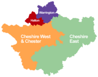
Today, Cheshire is a "ceremonial county," which means it's used for special events and traditions. It's managed by four main local councils: Cheshire East, Cheshire West and Chester, Halton, and Warrington.
Contents
What's in a Name? The Story of "Cheshire"
Cheshire's name comes from an old name for Chester. It was first written down in 980 as Legeceasterscir. This means "the shire of the city of legions," referring to Chester's Roman past. Even though the name appeared in 980, historians think the county was actually created earlier, around 920, by King Edward the Elder.
In the Domesday Book (a famous survey from 1086), Chester was called Cestrescir. Over time, as the English language changed, the name became simpler, eventually turning into "Cheshire" as we know it today.
Cheshire's Ancient Past: From Ice to Iron Age
Cheshire was covered by ice many times until about 11,500 years ago. But even before that, between 400,000 and 380,000 years ago, early humans lived here. Simple tools from that time have been found, suggesting that a type of early human called Homo heidelbergensis might have been present.
The Stone Age in Cheshire
Evidence of the Old Stone Age (Paleolithic) has been found, like axe heads at Tatton that are 12,000 years old!
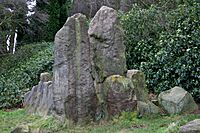
More people settled in Cheshire during the New Stone Age (Neolithic). A famous example is the Bridestones, a stone tomb near Congleton. This tomb is part of a "megalithic culture," where people buried groups of people in stone chambers under earth mounds. It's the oldest stone structure in Cheshire. Farming also began to develop during this time, with ancient flint tools and burnt grain found at Tatton from around 2,600 B.C.
Bronze Age and Iron Age Life
During the Bronze Age, people started living on high hills like Beeston Castle and Eddisbury hill fort. This suggests that society was becoming more focused on defense and possibly war.
By the Iron Age, Cheshire was home to the Celtic Cornovii tribe. They lived next to the Brigantes tribe to the north and the Deceangli and Ordovices tribes to the west. The Cornovii were known for trading salt from mines in places like Middlewich and Northwich.
Roman Rule in Cheshire
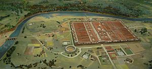
The Romans arrived in the lands of the Cornovii in 48 AD. By 70 AD, they had built a large fortress and town called Deva Victrix, which is now Chester. This fortress was bigger than others built around the same time in Britain, suggesting it might have been planned as a very important Roman center.
Chester also had a huge amphitheatre, built in the 1st century, which could hold 8,000 to 10,000 people. It's the largest military amphitheatre found in Britain!
The Romans also developed settlements at Northwich and Middlewich because of their important salt mines. Salt was very valuable to the Romans. Other Roman activities included melting lead at Runcorn and making pottery at Wilderspool. However, most of Cheshire remained rural, with native Britons focusing on farming.
Roman soldiers stayed in Chester until at least the late 4th century. Even after the Romans left Britain around 410 AD, the civilian settlement continued, and people likely used the old fortress walls for protection against raiders.
Cheshire in the Mercian Kingdom
After the Roman Empire fell in the 5th century, Britain broke into smaller kingdoms. Cheshire was in a tricky spot, on the border of kingdoms like Northumbria, Mercia, and North Wales, so it was a time of conflict. In 616, an Anglo-Saxon king named Æthelfrith won a big battle at Chester, which helped establish Anglo-Saxon power in the area.
Later in the 7th century, Cheshire became part of the kingdom of Mercia. As attacks from the Danes increased, the Anglo-Saxons made Chester's walls stronger for defense. Chester saw many battles between the English and Danes. Eventually, King Alfred of Wessex drove the Danes away from the city in 894–895. A peace treaty allowed the Danes to settle in the Wirral area, which is why some places there have Danish names, like Thingwall (meaning "a meeting place").
Alfred's daughter, Ethelfleda, who was known as the "Lady of the Mercians," built a new Anglo-Saxon fort (called a 'burh') at Chester.
Christianity also became widespread in Cheshire by the mid-7th century. One of the earliest churches was at Eccleston, where Christian burials have been found from as early as 390 AD. Towards the end of the 7th century, Saint Werburgh founded a religious center in Chester, which later became the first cathedral.
The River Mersey likely became the natural border between Mercia and Northumbria. To defend against the Danish kingdom in York, Mercia built a fort at Eddisbury in 914. Fortified settlements were also created along the Mersey, including Runcorn and Thelwall.
By 930, Cheshire was relatively peaceful. In 973, the Anglo Saxon Chronicle recorded that King Edgar of England came to Chester. He held court and had several kings row him on the River Dee, showing their loyalty to him.
Mercian place names can still be seen in Cheshire today. Look for names ending in 'ham' (meaning "a settlement"), like Frodsham or Weaverham, or 'burgh' or 'bury' (meaning "a fortified settlement"), like Wrenbury and Prestbury.
The Norman Conquest and Cheshire
William the Conqueror led the Norman Conquest of England in 1066. The Normans took land from the English, which led to many years of resistance. Cheshire, being a bit remote, put up a strong fight. Because of this, the Normans treated Cheshire very harshly, destroying land, burning crops, and leaving many people homeless.
In 1069, the last major resistance was crushed. English landowners had their property taken and given to Norman lords. The Domesday Book survey from 1086 shows how bad the damage was: most of Cheshire's lands were recorded as "wasta," meaning "wasteland." Before the conquest, these lands had been fertile. Chester itself was attacked in 1070, largely destroyed, and left devastated.
To control the county, William built a castle in Chester overlooking the River Dee. He also repaired the old Roman walls, making Chester one of the most heavily defended cities in Britain at the time.
William also created a new title: the Earl of Chester. He made Hugh d'Avranches the first Earl. Hugh, nicknamed "Hugh Lupus" (the wolf), ruled Cheshire almost like an independent king, with the full support of William. This is why Cheshire was declared a "County Palatine," a special title it still holds today. This meant the Earl had special powers, including his own courts and officials.
Norman earls continued to rule Cheshire until 1237, when the 7th Earl, John, died without a son. King Henry III then took back the title and gave it to his own son, Prince Edward (who later became King Edward I). Since then, the eldest son of every English monarch has held the title of Earl of Chester, along with the title of Prince of Wales.
Many other Norman castles were built across Cheshire to keep the peace and control the local population, who strongly disliked their Norman rulers for many years.
Changing Borders and Growing Towns
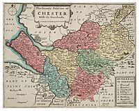
In 1086, Cheshire was actually bigger than it is today. It included areas that later became part of North Wales, like Flintshire. The area between the River Mersey and the River Ribble (which is now south Lancashire) was also linked to Cheshire in the Domesday Book, though the Mersey remained the main border. This northern border was uncertain until 1182, when the land north of the Mersey became part of the new county of Lancashire. Later, parts of Cheshire became part of Wales.
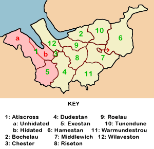
Over the years, the original twelve "hundreds" (smaller divisions of the county) in Cheshire changed and combined into seven: Broxton, Bucklow, Eddisbury, Macclesfield, Nantwich, Northwich, and Wirral.
Markets existed in Chester, Middlewich, and Nantwich even before 1066. The 12th and 13th centuries saw many more towns being granted market rights, probably as people got more used to Norman rule. For example, markets were created in Aldford and Alderley in 1253, Macclesfield in 1261, Congleton in 1272, and Over in 1280. However, competition was tough, and some markets, like those in Aldford and Burton, failed before the 14th century.
In 1397, Cheshire was even given the special rank of a "principality" by King Richard II. This was because of the strong support he received from the men of Cheshire, especially his personal guard of about 500 men called the "Cheshire Guard." As a result, the King's title changed to "King of England and France, Lord of Ireland, and Prince of Chester." No other English county has been honored in this way! However, Cheshire lost this special status when Richard II was overthrown in 1399.
Cheshire in the 17th Century
By the early 1600s, Cheshire had its own group of important families, known as the gentry, who were often descendants of the Normans. These families controlled trade, legal matters, and most of the land.
However, the English Civil War began in 1642 and changed everything. People chose sides based on their beliefs, either supporting the King (the Royalists) or Parliament (the Parliamentarians), no matter their social status. Chester was a strong Royalist city, while market towns like Stockport, Nantwich, and Northwich supported Parliament.
After some early fights in 1642, the local leaders in Cheshire tried to keep the county neutral and out of the war. They even signed an agreement called the Bunbury Agreement. But Cheshire's important location, especially the port of Chester, meant that national leaders couldn't allow it to stay neutral. Fighting soon broke out, and Cheshire saw many battles, including the sieges of Nantwich and Chester.
After the war, in 1655, England was put under military rule. Cheshire, Lancashire, and North Staffordshire were governed by a military leader. Some people, even those who had supported Parliament, planned riots, but these were stopped. Military rule ended in 1658, and the monarchy was restored with King Charles II of England.
In 1689, a regiment (a military unit) was formed in Chester to resist any attempt by James II to take back the throne. This regiment became the famous Cheshire Regiment.
Cheshire in the 18th and 19th Centuries
Towards the end of the 1700s, land was reorganized, and many small farms were combined into larger ones. The Industrial Revolution in nearby Lancashire and Manchester also led to many Cheshire farm workers leaving their homes to find work in factories. This meant that by 1870, a huge amount of Cheshire's land (98%) was owned by a small number of wealthy families (only 26% of the population).
However, industrialization also brought good things to Cheshire. The completion of the Trent and Mersey Canal in 1777, along with clever inventions like the Anderton Boat Lift, made it much easier to transport goods. This helped Cheshire cheese and salt become major exports from the county. The silk industry also grew in Macclesfield, especially after Charles Roe built a watermill there in 1744.
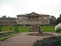
Cheshire continued to become a wealthy county in the 1800s. Grand country houses like Tatton Hall and Dunham Massey were expanded and improved during this time.
The railways arrived in Cheshire in the 1830s. The Grand Junction Railway, designed by famous engineers George Stephenson and Joseph Locke, opened in 1837. It connected Birmingham to Liverpool, passing through places like Crewe and Warrington. Crewe became a very important railway town, with its main engineering works located there.
In 1874, John Brunner and Ludwig Mond started a company called Brunner Mond in Winnington near Northwich. They began making soda ash (a chemical used in many industries) using a process that needed a lot of salt. The waste from this process was often dumped on subsided land, creating large, dangerous "limebeds" that made the land unusable.
The 19th century also saw the creation of formal public services in Cheshire. The Cheshire Constabulary (police force) was founded in 1857, and the Cheshire County Council (local government) was created in 1889.
Cheshire Today: The 20th and 21st Centuries
In 1974, a new law changed local government across England. Some areas in northern Cheshire became part of the new "metropolitan counties" of Greater Manchester and Merseyside. For example, Stockport and much of the Wirral Peninsula moved to these new areas. At the same time, areas like Widnes and Warrington (which used to be in Lancashire) were added to Cheshire.
Later, in 1998, Halton and Warrington became "unitary authorities." This means they manage their own local services and are independent of the main Cheshire County Council, but they are still part of Cheshire for ceremonial purposes, like for fire and police services.
In 2009, there were more changes to local government. The old Cheshire County Council and its districts were replaced by two new unitary authorities: Cheshire East and Cheshire West and Chester. Halton and Warrington were not affected by this change.
Today, Cheshire is a "ceremonial county" run by these four unitary authorities: Cheshire East, Cheshire West and Chester, Halton, and Warrington. It still has traditional roles like the Lord Lieutenant and High Sheriff for special events. Police and fire services continue to cover all four areas together.
The boundary of the Church of England's Diocese of Chester mostly follows the old Cheshire county line from before 1974. This means it includes areas like the Wirral and Stockport. For the Roman Catholic church, most of Cheshire is part of the Diocese of Shrewsbury.
See also
- Cheshire Archives and Local Studies Service
- History of agriculture in Cheshire
 | Jewel Prestage |
 | Ella Baker |
 | Fannie Lou Hamer |


