History of Seattle before white settlement facts for kids
Before European settlers arrived, the area that is now Seattle was home to many Native American villages. These people were part of the Coast Salish group and spoke the Lushootseed language.
The people living near Elliott Bay and along the Duwamish River, Black, and Cedar Rivers were known as the doo-AHBSH, or "People of the Doo" (meaning "Inside"). They had several important villages near Elliott Bay and the lower Duwamish River, which was then a rich estuary (where a river meets the sea). This area had lots of seafood.
People living around Lake Washington were called hah-choo-AHBSH or Xacuabš, meaning "People of a Large Lake" or "Lake People". They saw themselves as related to the doo-AHBSH but also as a separate group. Lake Washington used to drain into the Black River near what is now Renton. The Black River then joined the Cedar and Green rivers to form the Duwamish River, which flowed into Elliott Bay. Over time, as Europeans arrived, both the hah-choo-AHBSH and doo-AHBSH became known as the Duwamish tribe.
The land also had open grassy areas, like prairies, in places such as Belltown, South Lake Union, and near the University District. These grasslands were sometimes created and maintained by people through controlled burning to help game animals. The Liq'tid or Licton Springs area was a special place used for spiritual healing. People also gathered cranberries from a large marsh and bog called Slo'q 'qed in what is now Northgate.
Villages Near Downtown and the Duwamish River
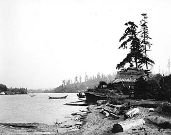
dzee-dzee-LAH-letch was the most important village on Elliott Bay around the year 1800, with about 200 people. Chief Seattle lived here for some time. The village had eight large khwaac'ál'al, which are longhouses—long buildings where many families lived together. Each was about 60 feet by 120 feet (18 m x 37 m). There was also a big potlatch house, a special building where people from different areas gathered for important ceremonies and celebrations. dzee-dzee-LAH-letch was located where King Street Station is today. This area used to have wide tidelands (areas covered by water at high tide and exposed at low tide) and a spit of land that separated Elliott Bay from a lagoon full of flounder.
tohl-AHL-too ("herring house") was another village on the west bank of the Duwamish River, near where it met Elliott Bay. This spot, now around south Harbor Island, was inhabited as early as the 6th century. It was left empty before 1800, but elders remembered it had seven longhouses and a very large potlatch house. A newer village nearby had three longhouses with 75-100 people.

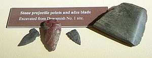
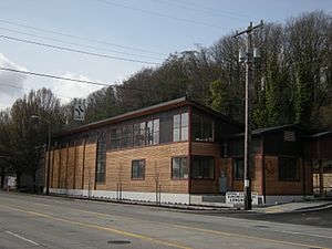
The Duwamish River was once a very rich estuary with lots of wildlife and wide tidal flats. In 1860, a pioneer named John Pike bought land here from the U.S. government, after the Treaty of Point Elliott in 1855. Later, shipyards were built here. In 1977, during construction for a marine terminal, archaeologists found ancient artifacts, which stopped the building work. This site is now part of Herring House Park. The park is 17 acres (6.9 ha) and has a natural shoreline, marsh, meadow, and forest. Many young fish, migrating salmon, harbor seals, ospreys, and bald eagles can be seen there. The Duwamish tribe's cultural center, the Duwamish Longhouse, overlooks the park. Nearby is Longfellow Creek, which was once called to-AH-wee (trout) and is now partly restored to its natural flow. Puget Creek provided fresh water and fish for the village.
Other villages in this area included:
- too-PAHLH-tehb: Located at the mouth of the eastern part of the Duwamish River's estuary, near what is now 1st Avenue and Spokane Street.
- yee-LEH-khood: A very old village on the west bank of a bend in the Duwamish River, now part of Terminal 107 Park.
- too-KWHEHL-teed: A village of the kehl-kah-KWEH-yah ("Proud People"), located farther upstream in what is now south Georgetown. This area was likely an open space maintained by people.
Villages North of Downtown
The shill-shohl-AHBSH people had a village called shill-SHOHL ("threading a needle"). This name likely came from the narrow opening from Salmon Bay out to Puget Sound. This village was on the north shore of what is now Salmon Bay, where the Ballard Locks were later built.
Villages Along Lake Washington
All the people living around Lake Washington were known as Xacuabš (hah-choo-AHBSH), or "Lake People." They saw themselves as connected to the Duwamish people but also as a distinct group. Lake Washington used to flow out through the Black River in Renton, which then joined other rivers to form the Duwamish River, emptying into Elliott Bay.
The hah-chu-AHBSH called what is now Bailey Peninsula in Seward Park skEba’kst ("nose"). The narrow strip of land connecting it to the mainland was cqa'lapsEb ("neck"). Since Lake Washington was about 9 feet (2.7 m) higher back then, this peninsula would become an island during seasonal floods. The area, including a large wetland and marsh to the north, was very rich in resources.
The Xacuabš had a village with two longhouses at xaxao'Ltc ("the sacred or taboo place"), near what is now Brighton Beach. Other longhouses were located along the southwest lake shore at SExti'tcb (Bryn Mawr), at TL’Ltcus (Pritchard's Island), and farther north at Leschi Park.
Besides providing food, Lake Washington was believed to be home to powerful spirits. The word xá?xa? also means sacred or mighty. The xaxao'lc at Brighton Beach was named for a spirit said to live in the lake there, whose presence was known by the unusual sound of the water. Near Colman Park, people believed in an ?ya’hos, a horned spirit linked to landslides and earthquakes. This is interesting because it's near the Seattle Fault, which caused a huge earthquake about 1,100 years ago, moving the ground more than 20 feet (6.1 m) vertically and causing a landslide on Mercer Island.
Two villages whose names are not known were located east of Downtown on Lake Washington. One possible village site of the skah-TEHLB-shahbsh was around what is now Genesee Park in Columbia City. Another skah-TEHLB-shahbsh village was at Leschi Park.
Rainier Beach (Atlantic City Park) is another possible site for a skah-TEHLB-shahbsh village, though its name is also unknown.
The main village of the hloo-weelh-AHBSH was near what is now Brooklyn Avenue, by a much larger Portage Bay, and SWAH-tsoo-gweel ("portage") on the north shores of Union Bay. This was near the Burke-Gilman Trail and Ravenna Park. Five longhouses were on the north side of the bay. Other longhouses were near the present University of Washington (UW) steam plant. In summer, this village often moved to Sahlouwil, which is now southeast Laurelhurst.
The village of hehs-KWEE-kweel ("skate") belonged to the hloo-weelh-AHBSH. Its name came from s'hloo-WEELH, meaning "a tiny hole drilled to measure the thickness of a canoe," referring to the narrow passage through the large and resource-rich Union Bay marsh. Parts of this marsh still exist as the Union Bay Natural Area and Foster Island. The trees and the island of Stitici (now Foster Island) were their ceremonial burial ground. The village was at the northeast tip of what is now Madison Park. One longhouse might have been used as a potlatch house. The Duwamish Tribe is currently working to protect this sacred site, which is in the path of a large expansion of SR 520.
TLEHLS ("minnows" or "shiners") was a village on the shores of what is now Wolf Bay in Windermere, south of Magnuson Park. A small prairie called BEbqwa'bEks was nearby. One to three longhouses have been recorded here. These people might have been connected to the hloo-weelh-AHBSH of Union Bay.
The village of too-HOO-beed belonged to the too-oh-beh-DAHBSH extended family. It was near what is now Thornton Creek in Matthews Beach, with Meadowbrook as their nearby land.


